A 10-day public comment period for all proposed Utah congressional maps began on Thursday. The maps available for comment include the six proposed by Utah’s Legislative Redistricting Committee as well as over 100 submitted by the public.
During committee meetings on Monday and Wednesday, the committee, made up of five state senators and five House members, presented maps for consideration. Five of the maps, options A through E, were presented by the majority, while the minority presented one map titled the “Escamilla/Owens Map.”
This map redrawing comes after a Utah Supreme Court ruling last year, saying the Utah Legislature shouldn’t have been allowed to amend 2018’s Proposition 4, also known as the Better Boundaries initiative.
Last month, 3rd District Court Judge Dianna Gibson ruled that with the initiative’s standards back in place, the existing congressional map cannot be used in the 2026 election since it does not meet Proposition 4’s requirements. The ruling requires the congressional map to be redrawn.
Whatever map is chosen to replace the one that was thrown out must follow the standards outlined in Proposition 4.
What are the standards outlined in Proposition 4?
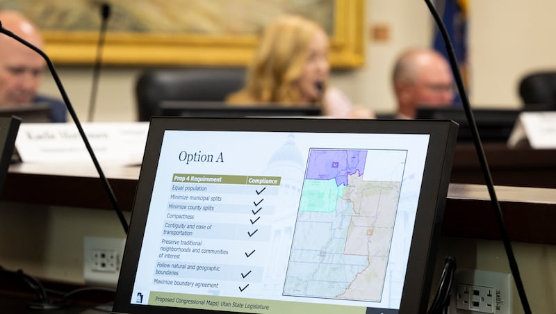
There are eight standards listed by Proposition 4 that should be followed by any proposed congressional map:
-
Minimize municipal splits
-
Contiguity and ease of transportation
-
Preserve traditional neighborhoods and communities of interest
-
Follow natural and geographic features and boundaries
-
Maximize boundary agreement among different types of districts
DN-OptionA
These standards are also meant to be prioritized in the order listed, per the ruling.

DN-OptionB
In order to have equal population in each district, Salt Lake County has to be split, since its population is greater than the ideal population of one district.

DN-OptionC
One other thing that complicates map drawing is that there are four cities in Utah that cross county boundaries: Bluffdale, Draper, Park City and Santaquin.

DN-OptionD
Removing partisan bias from map drawing is also a requirement of Proposition 4.

DN-OptionE
“The Legislature and the Commission may not divide districts in a manner that purposefully or unduly favors or disfavors any incumbent, elected official, candidate or prospective candidate for elective office, or any political party,” the proposition states.

DN-redistrctingF
A map must be generated without any political partisan data, and then afterward it will be analyzed for partisan symmetry.
One question that was asked multiple times during Monday’s public comment period is why the committee isn’t using the maps that were drawn by the Independent Redistricting Commission in 2021.
Rep. Candice Pierucci, R-Herriman, the committee’s co-chair, shared that Gibson’s order said that those maps are not allowable in this setting because the IRC was following SB200 and not Proposition 4 when drawing the maps.
The committee’s maps
When speaking about the five maps that were presented by the majority party, which makes up eight of the 10 seats of the committee, Pierucci said Wednesday that they all follow all the standards outlined in Proposition 4.
Maps A, B and C were complimented by members of the committee on Wednesday for how they respected geographical features and boundaries and also for how they mixed rural and urban areas.
Rep. Walt Brooks, R-St. George, said he appreciates how maps A and B have borders on the Colorado River and Lake Powell, because they’re some of the most significant water resources in the state. He said that to be able “have two Congress individuals that represent that water source is critical to the entire state of Utah.”
Options D and E were criticized for not being as geographically compact as the others.
All five maps were also highlighted for the low number of both municipal and county splits. Here’s a look at the splits in each of the maps:
Option A
Municipal splits: North Salt Lake, Pleasant Grove, West Valley
County splits: Davis, Salt Lake, Utah
Option B
Municipal splits: North Salt Lake, Provo, West Jordan
County splits: Davis, Salt Lake, Utah
Option C
Municipal splits: Millcreek, North Salt Lake, Pleasant Grove
County splits: Davis, Salt Lake, Utah
Option D
Municipal splits: Eagle Mountain, Layton, Taylorsville
County splits: Davis, Salt Lake, Utah, Tooele, Wasatch
Option E
Municipal splits: Cottonwood Heights, Provo
County splits: Salt Lake, Summit, Utah, Wasatch
The Escamilla/Owens map
The Escamilla/Owens Map was presented on Wednesday by Rep. Doug Owens, D-Millcreek, and Sen. Luz Escamilla, D-Salt Lake City. This map was created by taking a map previously created by the Independent Redistricting Commission and adjusting it to follow Proposition 4.
One of the biggest criticisms of the map was the high number of splits, as it has 13 municipal splits and four county splits.
Other criticism of the map included the fact that it does not just split neighborhoods, but streets and cul-de-sacs were split up into different districts.
Sen. Mike McKell, R-Spanish Fork, also added that one priority of Proposition 4 is making districts geographically compact. He said that this map fails to do that.
Maps submitted by the public
West Valley City Sen. Daniel Thatcher, a member of the Forward Party and the Legislature’s only non-Republican or Democratic member, has also presented his own congressional map for consideration.
Thatcher drew his map when the state was last redrawing boundaries. According to him, it complies with the Better Boundaries initiative, as previously reported by the Deseret News.
His map does split up Salt Lake County between all four U.S. House districts, which is a criticism of the state’s most recent map that was thrown out.
Members of the public were also able to submit their own maps. There have been 148 total congressional maps submitted online for comment. These maps all split up the state in different ways, with many of the creators of these maps referring to them as “fair.”
Some of the maps are labeled as to how many districts each party would be able to win, which is something that cannot be considered in choosing a final map.
Over the next 10 days, members of the public are able to comment on all submitted maps. Because the public comment period has officially begun, no more maps can be submitted for consideration by the Legislature.
What comes next?
The 10-day public comment period goes until Oct. 5. On Oct. 6, the committee will meet to decide which map it will present to the rest of the Legislature. Later that day, there will be a special session where the Legislature will vote on the map.
That map will then be submitted to Gibson, who can then either approve the Legislature’s map if it complies with Proposition 4 or, if it is not approved, she can choose a map submitted by other groups. She has until Nov. 10 to confirm a map so that preparations for the 2026 midterm elections can begin.
“We value and want your input on the proposed maps, which is why there are multiple options for you to consider. But to the extent that you feel inclined to share feedback that relates to partisanship, please know that we cannot consider it,” Pierucci said.
For more information on the process and to view all maps available for comment, people can visit the committee’s website.