As residents across the United States brace for storms that could also include tornadoes, those along the East Coast are watching a couple of disturbances in the tropics, especially one heading for the Caribbean.
Just a day ago the National Hurricane Center’s tropical outlook map showed nothing, with no tropical activity expected over the next seven days.
➤ Weather alerts via text: Sign up to get updates about current storms and weather events by location
But as of Friday morning, Oct. 17, there are two disturbances out there. The one showing the most potential for development, is one in the central Atlantic moving toward the Caribbean, where water temperatures are very warm.
During this part of the season, “tropical development tends to occur close to Central America, the north-central Atlantic and in waters surrounding the southeastern U.S. coast,” according to AccuWeather.
With waters in the Caribbean very warm, if conditions are right, it’s possible a tropical storm or hurricane could develop during the final weeks of the season.
The next named storms of the season will be Melissa and Nestor.
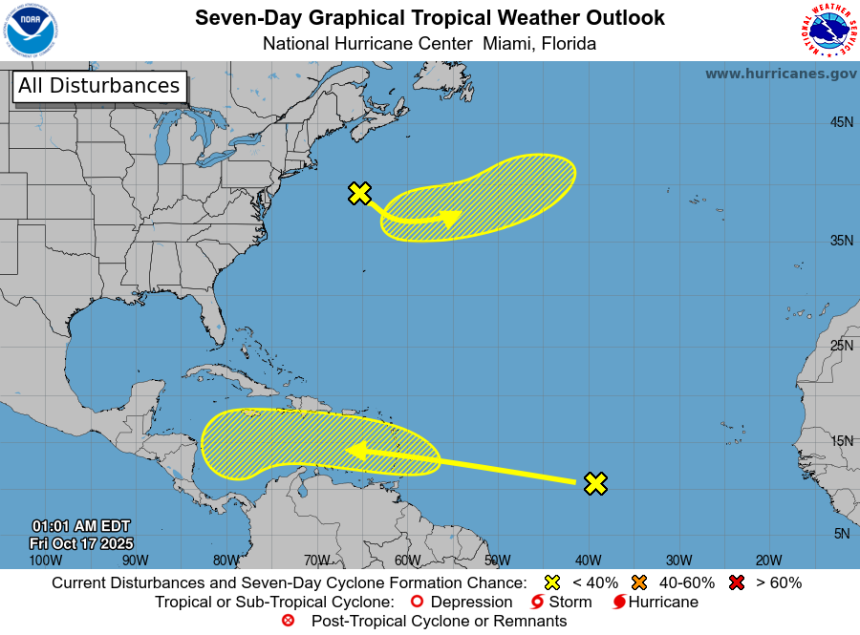
Here’s the latest advisory from the National Hurricane Center as of 8 a.m., Oct. 17:
Is there a hurricane coming toward North Carolina?
No.
The National Hurricane Center is tracking two disturbances in the Atlantic: one in the northern Atlantic off the U.S. northern coast and the other in the tropical central Atlantic moving toward the Caribbean.
The southern tropical wave is expected to move into the Caribbean late this weekend, according to AccuWeather.
Residents across the Caribbean and southern U.S., including North Carolina, should keep an eye on it and, as always, be prepared.
“There may be as many as three more tropical storms and perhaps two more hurricanes for the rest of the season,” DaSilva said.
Could Tropical Storm Melissa develop next week?
There’s just over a month left in the 2025 Atlantic hurricane season but AccuWeather forecasters warned now is not the time to ignore the tropics, especially the Caribbean.
A non-tropical system over the northwestern Atlantic may develop into a tropical or subtropical storm over the next several days, which would be well ahead of the tropical wave near the equator, according to AccuWeather.
The southern tropical wave is one forecasters are keeping an eye on after it moved off the coast of Africa earlier this week.
“This is the tropical wave that could go on to define the Atlantic tropical season in terms of impact, should it get past hurdles in the coming days,” said AccuWeather Chief On-Air Meteorologist Bernie Rayno.
The tropical wave is expected to remain poorly organized until it crosses the islands marking the eastern side of the Caribbean late this weekend. Until then, it faces a battle with dry air, wind shear and even its close proximity to South America, all conditions that hinder development.
If it gets into the central Caribbean, chances for development increase.
“The ocean heat content in the Caribbean is currently the third highest on record, behind the last two years,” said Alex DaSilva, AccuWeather lead hurricane expert, said via email Oct. 15.
“The Caribbean’s been very quiet this year, which has allowed water temperatures to get very high. We’ve said all season, if anything gets into the southern Gulf or Caribbean, we need to watch it carefully because environmental conditions are extremely favorable for development.
“Once it gets into the central Caribbean, there doesn’t look like much wind shear at all, and we could see this take off pretty quickly, if it’s able to survive the journey. It’s still possible the wave gets snuffed out before the Caribbean, although we think it will make it.
“If it reaches the Caribbean next week, we’ll have to monitor it very carefully — especially in the central Caribbean about a week from now. It has the possibility to intensify, potentially quickly, because wind shear is low and water temperatures are exceptionally warm,” DaSilva said.
Could North Carolina see any tropical impacts from wave approaching Caribbean?
AccuWeather forecasters said there are several scenarios that could affect where the tropical wave could go and who could be impacted:
-
“One scenario is that the wave waits to develop until it approaches Central America. Depending on steering breezes at the time, it may continue westward across Central America or turn northward toward Florida.
-
“In a worst-case scenario, the wave could organize into a tropical storm over the central Caribbean and move northward with a track near the U.S. Atlantic coast. Non-tropical weather systems could then draw the storm onshore with heavy rain, coastal flooding and high winds during the last week of the month.”
“There is a wide range of development and track possibilities,” AccuWeather said.
“However, based on the anticipated weather pattern and historical records, the Caribbean could be the spot for the next tropical storm and hurricane to form and affect populated areas from next week to the end of the month.”
Most-active period of Atlantic hurricane season ends
The most-active period of the Atlantic hurricane season runs from mid-August through mid-October, with the peak occurring Sept. 10. Hurricane season runs from June 1 through Nov. 30.
That doesn’t mean a tropical storm or hurricane can’t occur at any time.
According to National Hurricane Center records dating back to 1851, at least one named tropical storm or hurricane has occurred in every month of the year in the Atlantic.
However, off-season systems are not common and do not develop every year, according to AccuWeather.
When tropical systems do develop between December and May, they tend to remain weak with a majority of systems never reaching hurricane status, according to AccuWeather.
“As the peak period for tropical waves concludes in late October and November, tropical development tends to occur close to Central America, the north-central Atlantic and in waters surrounding the southeastern U.S. coast,” AccuWeather said.
Are there any other tropical waves, disturbances in Atlantic basin now?
Central Atlantic: A tropical wave located over the central tropical Atlantic more than 1000 miles east of the Windward Islands continues to produce a large area of showers and thunderstorms. Gradual development of this system is possible over the next several days while it moves generally westward at 15 to 20 mph. Regardless of development, this system is expected to bring heavy rainfall and gusty winds to the Windward Islands late this weekend and then move across the Caribbean Sea much of next week.
-
Formation chance through 48 hours: low, 10 percent.
-
Formation chance through 7 days: low, 30 percent.

North Atlantic: A non-tropical area of low pressure is located well off the coast of the Northeast United States. There is a slight chance that the system could develop some subtropical characteristics during the weekend before it turns northeastward over cooler waters by early next week
-
Formation chance through 48 hours: low, 10 percent.
-
Formation chance through 7 days: low, 10 percent.
Who is likely to be impacted by tropical waves?
It’s too early at this time to determine if there will be any impact to North Carolina or the U.S. from the tropical wave moving toward the Caribbean, or another tropical wave in the eastern Atlantic.
The area of low pressure off the northern coast of the U.S. is expected to move away from the U.S. by the weekend and into cooler waters, ending its chance for development.
Forecasters urge all residents to keep an eye on the tropics and to always be prepared.
North Carolina weather radar

North Carolina weather watches and warnings
Interactive map: Hurricanes, tropical storms that have passed near your city
Stay informed. Get weather alerts via text
Brandi D. Addison covers weather across the United States as the Weather Connect Reporter for the USA TODAY Network.
This article originally appeared on Asheville Citizen Times: Is Tropical Storm Melissa brewing? What to know in North Carolina