September flooding in the U.S. is usually from hurricanes and tropical storms, or associated with the Desert Southwest’s monsoon.
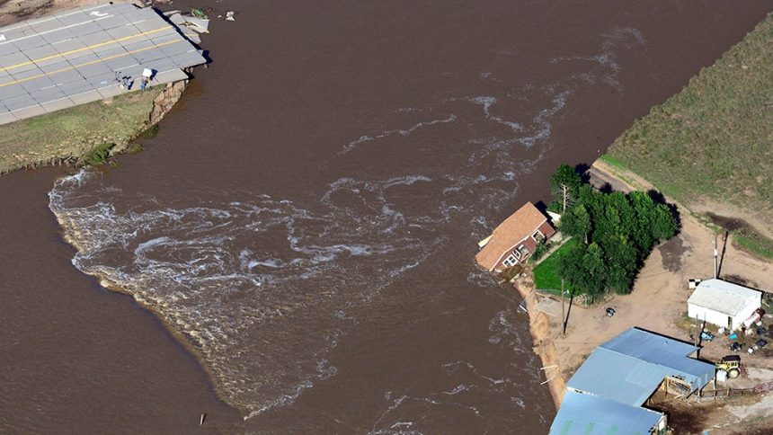
But on Sept. 12, 2013, 12 years ago today, parts of Colorado were in the midst of a torrential rain event that triggered widespread flooding from the foothills to the adjacent Plains.
Over 17 inches of rain fell in parts of Boulder County from Sept. 11 to 13. Just over 9 inches of rain fell over the city of Boulder on Sept. 12 alone, crushing the previous all-time calendar day record from 94 years ago by over 4 inches.
Parts of the east Denver metro area picked up over 14 inches of rain, roughly the average for an entire year.
This torrent of water roared down the Big Thompson Canyon, Boulder Creek, St. Vrain Creek and various others before eventually draining into the South Platte River, where it could be seen by satellites days later pushing downstream, setting records on the plains of northeast Colorado.
The scope of this event was impressive by Front Range standards. Parts of 18 cities and towns were flooded, from Denver’s southwest foothills suburbs to Boulder, Greeley and Fort Collins.
Just over 2,200 homes and businesses were destroyed and another 26,000 were damaged, according to the National Weather Service. Two hundred miles of roads and 50 major bridges were damaged, and FEMA declared 15 counties as federal disaster areas.
Nine people died in the floods, 3,000 were rescued and 19,000 were evacuated.
Total damage was estimated at $2 billion by NOAA.
Jonathan Erdman is a senior meteorologist at weather.com and has been covering national and international weather since 1996. Extreme and bizarre weather are his favorite topics. Reach out to him on Bluesky, X (formerly Twitter) and Facebook.