Brewing Tropical Storm Imelda to approach and threaten Carolinas, Georgia
Tropical trouble is brewing for the southeastern United States during the first part of the new week in the form of heavy rain, strong winds, flooding and erosive surf. A batch of showers and thunderstorms near the Bahamas has organized into a tropical depression and is forecast to strengthen into the next tropical storm and hurricane of the 2025 Atlantic season.

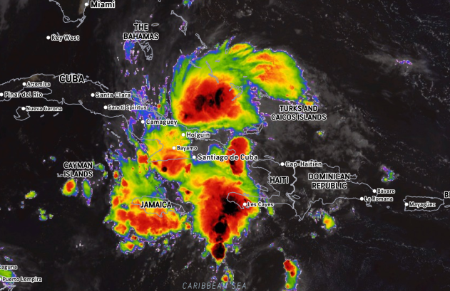
This close-up image of Tropical Depression Nine was captured on Saturday, Sept. 27, 2025. This storm is highly likely to become a tropical storm (Imelda) and could strengthen into a hurricane before approaching the Carolina coast of the United States early next week. (AccuWeather Enhanced RealVue™ Satellite)
A tropical wave that AccuWeather’s team of hurricane experts has been tracking for two weeks and identified as a tropical rainstorm earlier this week to raise public awareness and assist with preparation is on the cusp of becoming a tropical storm.
On Saturday, the National Hurricane Center officially classified the rainstorm as Tropical Depression Nine. A tropical storm watch is in effect for the east coast of Florida.

The dashed red line represents AccuWeather meteorologists’ forecast path for the eye of the storm. The gray shaded areas on either side of the forecast path represent alternative paths the storm could take based on changing steering conditions. Tropical storm and hurricane conditions will extend well beyond the track of the eye.
The next name on the list of tropical storms for this year is Imelda.
Development factors in the coming days for (Imelda) include warm water, a moist atmosphere environment and lowering combative winds (wind shear).
Steering currents for Imelda will be determined by a large area of high pressure over the central Atlantic, the strong circulation of Category 4 Hurricane Humberto tracking near Bermuda, and an area of high pressure in the northeastern United States that may block Imelda’s path.
Imelda is forecast to take a slightly west of north track through Tuesday, which will bring the tropical cyclone close to the coasts of Georgia and South Carolina. As Imelda moves along, it is forecast to quickly gain wind intensity and become a hurricane.
Impacts in the Bahamas, Florida
Strong wind gusts, flooding downpours, coastal flooding and dangerous seas will spread northward through the Bahamas. The AccuWeather RealImpact™ Scale for Hurricanes in the Caribbean and the Bahamas is one.

AccuWeather.com
With the center of the storm forecast to remain east of Florida, the worst conditions will stay to the east of the state.
However, seas, breakers and rip currents will increase along the east coast of Florida with some beach erosion. Some bands of heavy rain and gusty thunderstorms may circulate into the Florida Peninsula, especially the eastern and central counties.

AccuWeather.com
Conditions are expected to become more significant farther north along the U.S. coast.
Imelda’s track scenarios: Multiple possible paths midweek
Imelda will get close enough to the Georgia, South Carolina and North Carolina coasts to bring heavy rain, strong wind gusts, dangerous and erosive surf, and flooding from heavy rain and storm surge effects.
Flooding is often one of the most damaging and dangerous aspects of hurricanes.

AccuWeather.com
At this time, there is a zone where 8-16 inches of rain is forecast to fall on parts of the Carolinas with an AccuWeather Local StormMax™ of 24 inches. Depending on how far inland this level of rainfall occurs, as well as slightly less rainfall, there is a high potential for major river flooding.
The heaviest rain and greatest flood potential are forecast to stay east of the hardest-hit areas of western North Carolina from a year ago, associated with Hurricane Helene. But any westward shift in storm track could bring torrential rain into these areas. Recall that Helene moved inland from the northeast Gulf coast and traveled northward through Georgia to the southern parts of the Appalachians.
The amount of rain could be less overall in the southeastern U.S. if Imelda stops, stalls and shifts away from the Carolina coast at midweek. However, the rain could be greater if Imelda manages to move just inland and stall.

AccuWeather.com
The freshwater flooding rainfall will be complicated by storm surge flooding in the barrier islands and the coastal communities on the mainland. Cities such as Charleston and Myrtle Beach, South Carolina, and Wilmington, North Carolina, could face major flooding.
The river flooding may follow several days after the storm’s winds ease. Residents along flood-prone rivers should monitor forecasts closely for the potential of inundation next week.
How strong winds and wave action are along the coast, as well as the northern extent of the rain, will depend on Imelda’s intensity, track and forward speed.
A hurricane that stalls offshore could result in multiple days of damaging winds and significant coastal erosion.

AccuWeather.com
There is the possibility that Imelda will only be within 150 miles or so of the coast or turn out to sea-something AccuWeather meteorologists will continue to monitor closely. Such a track would still bring some heavy rain and gusty winds to southeastern Georgia and the central and eastern Carolinas, due to interaction with a non-tropical storm system and the circulation around high pressure in the Northeast that would pump in some Atlantic moisture. However, in this case, most major flooding problems and high levels of damaging winds would be avoided.
Mid-Atlantic impacts from the storm may be limited, but not entirely ruled out
A storm that stalls near the Carolina coast, turns out to sea or wanders just inland over the Carolinas is unlikely to spread rain very far to the north in the mid-Atlantic. At this point, rain heavy enough to cause flooding may reach southeastern and south-central Virginia, with lesser rain extending into central Virginia and the lower part of the Delmarva Peninsula.

AccuWeather.com
The difference in pressure between Imelda and the same high in the Northeast bringing dry air will create stiff northeast breezes in the mid-Atlantic, raising seas and surf to the point where rip currents will be strong and beach erosion and coastal flooding can occur at times of high tide for much of the new week.
The full moon at week’s end may keep tides elevated.

AccuWeather.com
There is little indication at this time that Imelda would track farther north along the coast than the Carolinas and that rain would reach much beyond southern Virginia.
Want next-level safety, ad-free? Unlock advanced, hyperlocal severe weather alerts when you subscribe to Premium+ on the AccuWeather app. AccuWeather Alerts™ are prompted by our expert meteorologists who monitor and analyze dangerous weather risks 24/7 to keep you and your family safer.