California’s rainy season is off and running as a powerful storm system unleashed bands of rain across Northern California, the Bay Area and Central Coast, with light snow falling in the Sierra Nevada.
The storm system will strengthen and slowly move down the coast of California on Monday evening, bringing widespread impacts, including heavy rain at the coast, substantial snow inland and severe thunderstorms in Southern California.
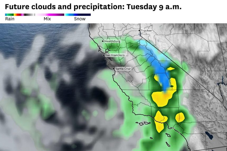
Here is the latest forecast.
Bay Area storms
Rain was slow to reach the Bay Area on Monday as the incoming storm system had to overcome a stubbornly dry air mass lingering over the region.
As the main low-pressure system slides down the California coast on Monday, rain coverage will expand and intensify across the Bay Area through Monday evening. Flood advisories are in place in Marin, San Francisco, Contra Costa and Alameda counties, as some heavier pockets of rain will drop an additional half inch to an inch over just a few hours.
The unusually cold air in the upper atmosphere associated with the storm system will continue to destabilize the atmosphere into Monday evening. That could result in heavy downpours, localized flooding, small hail and possibly an isolated waterspout or weak tornado near the coast and the Santa Cruz Mountains.
Rainfall totals will vary widely for the rest of Monday, generally between a quarter and three-quarters of an inch, with over an inch possible in higher terrain and less in sheltered valleys.
An additional half inch to an inch of rain is possible across the Bay Area from Monday evening through Tuesday evening. (Baron/Lynx )
Moderate rain with pockets of heavier showers will persist until around 8 p.m. across the Bay Area before easing. Scattered showers and a few isolated thunderstorms will linger overnight and into Tuesday morning, though their exact locations and intensities remain uncertain.
Overnight, temperatures will fall into the 50s, making for a damp, chilly night across the Bay Area.
Expect another cool, cloudy and occasionally wet day Tuesday in the Bay Area, especially through midday. Tuesday’s forecast does come with an elevated level of uncertainty, stemming from the slow-moving nature of the system. As the storm slides south along the coast, it will stir up pockets of showers here and there, leaving other areas dry.
Gradual clearing should arrive by late afternoon as the storm finally moves east, allowing pockets of sunshine to return. Temperatures will remain stubbornly cool, with highs stuck in the upper 50s to low 60s across most of the Bay Area.

Most of the state’s advisories and warnings from the storm are focused over the Sierra and Southern California. (Pivotal Weather )
Sierra snow
Winter storm warnings were in effect across the Sierra Nevada on Monday, marking the earliest such warning for the mountain range since 2011. Light snow fell near Donner Pass for much of the day on Monday, but the bulk of the snow is due to arrive Monday evening and on Tuesday.
The overall snowfall forecast remains tricky, especially around Tahoe. The uncertain track of the low pressure system brings a wide variety of outcomes into play. As of Monday afternoon, it appeared that the center of the low pressure system would slide a bit to the south and west of the Sierra, pulling the heaviest precipitation with it. As such, Truckee and the Lake Tahoe basin will likely see about an inch or two of snow on Tuesday before precipitation shifts further south. However, should the storm center track further north, several inches of snow would fall around Tahoe.

About 1 to 3 feet of snow will fall across the Sierra at elevations above 6,500 feet through Wednesday. (Baron/Lynx )
The jackpot for snow in the Sierra still looks to be in the Central Sierra in Tuolumne, Mono, Madera and Fresno counties. Officials closed Tioga Pass through Yosemite National Park on Monday afternoon since heavy snow is expected to fall in these spots on Tuesday, with snowfall levels reaching down to about 6,000 feet and 1 to 2 feet of snow expected, including at Mammoth. The High Sierra (above 8,000 feet) will see up to 3 feet of snow.
Southern California flood threat
The most extreme impacts from the storm system figure to be in the Sierra foothills and the coastal mountains of the Southern California Transverse Ranges. As the storm continues to move down the California coast Monday night, it will reach its peak intensity and start to pull in moisture rich air from the warm Pacific. That moist air mass will slam into the Transverse Ranges of Southern California, including the San Gabriel Mountains, San Bernardino Mountains and Santa Monica Mountains. Heavy rain will develop in these elevated spots, with 2 to 4 inches of rain likely to fall by Wednesday morning.

The National Weather Service is calling for a slight risk of excessive rainfall over the parts of Southern California on Tuesday (Baron/Lynx )
The bigger concern won’t necessarily be the rainfall totals, but rather the rates of 0.5 to 1 inch per hour that will come with some of the heavier storm cells. That kind of rainfall intensity will almost certainly lead to flash floods and more importantly, to debris flows around recent wildfire burn scars. In anticipation of that threat, authorities in Los Angeles County have issued evacuation warnings for Palisades, Franklin and Eaton fire burn scars for Monday night and Tuesday.
A similar flood threat exists on the west-facing foothills of the Sierra. Flood watches are in place in the foothills above 2000 feet from Mariposa county down through Kern County, where rainfall rates between 0.25 and 0.5 inches per hour will develop at times late on Monday and into Tuesday, creating flooding and debris flows at recent burn scars, like those produced by the Garnett Fire.
Los Angeles tornado threat
The National Weather Service Storm Prediction Center warns of a low-end risk of tornadoes in the Los Angeles area and other parts of Southern California on Tuesday. Overall chances are low, but the risk is greatest along the coast from roughly Santa Barbara to Oceanside (San Diego County) before 2 p.m.
A low-end tornado threat also exists along the Central Coast from San Luis Obispo to Oxnard (Ventura County) on Monday night. This week’s weather pattern closely resembles others that have produced twisters in the Los Angeles area, the weather service said.
Even if tornadoes don’t spin up, there is a chance of damaging wind gusts up to 60 mph, the Storm Prediction Center warns.
Meteorologist Anthony Edwards contributed to this story.
This article originally published at California’s first big storm of the season is just getting started – here’s what’s next.