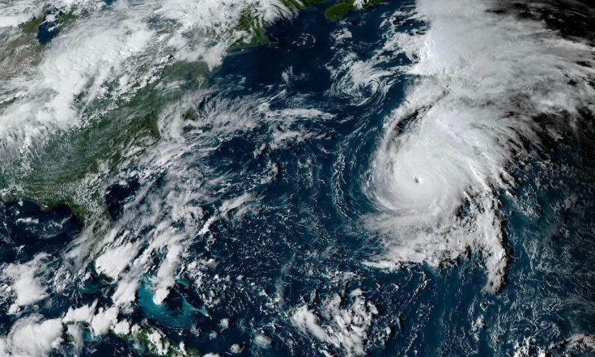
After a slow start, the 2025 hurricane season is picking up fast. Hurricane Gabrielle surged up from a tropical storm not a powerful Category 4 hurricane with maximum sustained winds of 140 mph in about a day, according to a National Hurricane Center update. It’s expected to weaken as it moves out into the Atlantic, but two more systems are lining up after it.
On the forecast track, the center of Hurricane Gabrielle is moving north-eastward into the open Central Atlantic.
➤ Weather alerts via text: Sign up to get updates about current storms and weather events by location
While there were no watches or warnings in effect Tuesday morning, Sept. 23, forecasters warned residents in Bermuda should monitor Gabrielle’s progress. A rip current statement is in effect for the east coast of Florida down to West Palm Beach until Wednesday, Sept. 24.
Gabrielle’s tropical-storm-force winds extended 140 miles from the center on Tuesday, Sept. 23. Hurricane-force winds extend outward up to 40 miles.
Gabrielle is the seventh named storm of the 2025 Atlantic hurricane season and the first tropical storm since Tropical Storm Fernand formed Aug. 23.
It is also now the second hurricane of the season.
Erin became the season’s first hurricane on Aug. 15, and rapidly intensified into a major hurricane with peak winds hitting 160 mph on Aug. 16.
Where is Hurricane Gabrielle?
Special note on the NHC cone: The forecast track shows the most likely path of the center of the storm. It does not illustrate the full width of the storm or its impacts, and the center of the storm is likely to travel outside the cone up to 33% of the time.
-
Location: 180 miles east-southeast of Bermuda
-
Maximum sustained winds: 140 mph
-
Movement: north-northeast at 12 mph
Hurricane Gabrielle strengthens to Category 4
At 5 p.m., the center of Hurricane Gabrielle was located near latitude 31.7 North, longitude 61.8 West.
Gabrielle is moving toward the north-northeast near 12 mph. This general motion is expected tonight, followed by a faster northeastward or east- northeastward motion on Tuesday and Wednesday. On the forecast track, the center of Gabrielle is expected to pass east of Bermuda tonight.
NOAA Hurricane Hunter aircraft and satellite data indicate that the maximum sustained winds are near 140 mph with higher gusts. Gabrielle is a category 4 hurricane on the Saffir-Simpson Hurricane Wind Scale. Little significant change in strength is forecast tonight, followed by a gradual weakening on Tuesday and Wednesday.
Hurricane-force winds extend outward up to 40 miles from the center and tropical-storm-force winds extend outward up to 140 miles.
The estimated minimum central pressure is 948 mb.
Rapid intensification: How did Hurricane Gabrielle become a Category 4 in a day?
Hurricane season set to ramp up by late September
While the basin has been quiet — even through the climatological peak — officials warn that activity is likely to increase as suppressing factors like dry air and wind shear begin to fade.
Of particular concern are storms that form close to the United States. Unlike tropical waves that roll off Africa and give forecasters days to track, systems that develop in the Gulf, Caribbean or off the Southeast coast can catch residents with little time to prepare.
These “homegrown” storms can also rapidly intensify in the Gulf’s extremely warm waters, AccuWeather forecasters said.
Are any hurricanes coming to North Carolina?
No. Hurricane Gabrielle is the only named storm in the Atlantic currently and is moving to the northeast toward Bermuda.
Conditions can change rapidly, though, and forecasters warn residents to not become complacent and to always be prepared.
How does the 2025 Atlantic hurricane season compare to last year in North Carolina?
For North Carolina, the season has been quiet so far, following a similar pattern to 2024, although Hurricane Erin brought some significant impacts to the Outer Banks.
In early August of last year, Tropical Storm Debby brought heavy rain, flash flooding, tropical storm–force wind gusts, minor coastal flooding and three weak tornadoes to southeastern North Carolina after making landfall in Florida’s Big Bend region on Aug. 5, 2024, and then a second landfall in South Carolina’s Bulls Bay between Charleston and Georgetown early on Aug. 8, 2024.
By late September, the state tracked Tropical Storm Helene, which caused flash floods, landslides and hundreds of fatalities after moving through the Appalachians.
So far, no storms have directly affected the state, but Colorado State researchers say North Carolina has one of the highest odds of seeing impacts from a hurricane or named storm this season — second only to Florida.
When does the Atlantic hurricane season end in North Carolina?
The Atlantic hurricane season runs from June 1 through Nov. 30.
Ninety-seven percent of tropical cyclone activity occurs during this time period, NOAA said.
The Atlantic basin includes the northern Atlantic Ocean, Caribbean Sea and Gulf of America, as the Gulf of Mexico is now known in the U.S. per an order from President Donald Trump. NOAA and the National Hurricane Center are now using Gulf of America on its maps and in its advisories.
The peak of the season is Sept. 10, with the most activity happening between mid-August and mid-October, according to the Hurricane Center.
Prepare now for hurricanes
Delaying potentially life-saving preparations could mean waiting until it’s too late. “Get your disaster supplies while the shelves are still stocked, and get that insurance checkup early, as flood insurance requires a 30-day waiting period,” NOAA recommends.
-
Develop an evacuation plan: If you are at risk from hurricanes, you need an evacuation plan. Now is the time to begin planning where you would go and how you would get there.
-
Assemble disaster supplies: Whether you’re evacuating or sheltering-in-place, you’re going to need supplies not just to get through the storm but for the potentially lengthy aftermath, NOAA said.
-
Get an insurance checkup and document your possessions: Contact your insurance company or agent now and ask for an insurance check-up to make sure you have enough insurance to repair or even replace your home and/or belongings. Remember, home and renters insurance doesn’t cover flooding, so you’ll need a separate policy for it. Flood insurance is available through your company, agent, or the National Flood Insurance Program. Act now, as flood insurance requires a 30-day waiting period.
-
Create a family communication plan: NOAA says to take the time now to write down your hurricane plan and share it with your family. Determine family meeting places, and make sure to include an out-of-town location in case of evacuation.
-
Strengthen your home: Now is the time to improve your home’s ability to withstand hurricane impacts. Trim trees; install storm shutters, accordion shutters, and/or impact glass; seal outside wall openings.
North Carolina weather radar

North Carolina weather watches and warnings
Interactive map: Hurricanes, tropical storms that have passed near your city
Stay informed. Get weather alerts via text
Brandi D. Addison covers weather across the United States as the Weather Connect Reporter for the USA TODAY Network. She can be reached at baddison@gannett.com.
This article originally appeared on Asheville Citizen Times: Hurricane Gabrielle moves in Atlantic. Will it impact North Carolina?