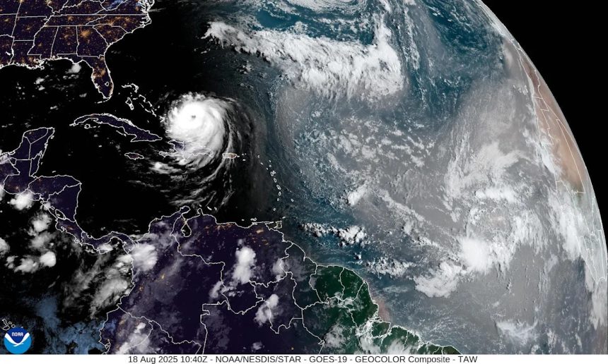
Hurricane Erin was a Category 4 storm again Monday morning and is expected to grow even larger and stronger, according to the latest advisory from the National Hurricane Center.
Although Erin is forecast to move north between the U.S. and Bermuda, life-threatening surf and rip currents are likely across the Atlantic coast from Florida to Canada.
➤ Weather alerts via text: Sign up to get updates about current storms and weather events by location
Dare County in North Carolina declared a state of emergency and issued a mandatory evacuation for Hatteras Island. The National Weather Service warned waves of 15 to 20 feet are expected in Cape Hatteras, North Carolina, and issued a beach hazards statement and high surf advisory for much of the week.
Residents along the North Carolina coast were warned there is a risk of strong winds associated with the outer rainbands of Erin around the middle of the week, as well as a threat for significant coastal flooding and beach erosion, according to the National Weather Service’s Weather Prediction Center.
Erin is a huge storm and expected to grow larger. As of Monday morning, hurricane-force winds extend outward up to 80 miles from the center, and tropical-storm-force winds extend outward up to 230 miles.
➤ Hurricane drama vs. data: Why Erin is a miniscule threat to Florida, U.S. east coast
Hurricane Erin projected path. Latest on Category 4 storm
Special note on the NHC cone: The forecast track shows the most likely path of the center of the storm. It does not illustrate the full width of the storm or its impacts, and the center of the storm is likely to travel outside the cone up to 33% of the time.
-
Location: 105 miles north-northeast of Grand Turk Island; 699 miles southeast of Stuart; 915 miles south-southeast of Cape Hatteras, North Carolina
-
Maximum sustained winds: 130 mph
-
Movement: northwest at 13 mph
Hurricane Erin joins small group of Cat 5 storms
Tropical Storm Erin strengthened into a hurricane Friday morning, Aug. 15 and became a monster Category 5 storm Saturday, Aug. 16, before dropping back down to a Category 3 storm Aug. 17.
Since 1970, five Atlantic hurricanes have had winds higher than 145 mph by Aug. 16: Allen (1980), Charley (2004), Dennis (2005), Emily (2005) and Beryl (2024).
➤ Hurricane drama vs. data: Why Erin is a miniscule threat to Florida, U.S. east coast
Spaghetti models for Hurricane Erin. Where is the storm going?
Special note about spaghetti models: Illustrations include an array of forecast tools and models, and not all are created equal. The hurricane center uses only the top four or five highest performing models to help make its forecasts.
Is there a hurricane coming to Florida?
No. Erin is moving northwest and the center of the storm is expected to remain east of Florida.
While Erin is expected to remain offshore, it is expected to bring life-threatening surf and dangerous rip currents along the Atlantic coast from Florida to Canada.
Remember, forecasts can change so it’s always best to be prepared.
What impacts could Hurricane Erin have on Florida?
Ocean swells associated with Hurricane Erin are expected to bring large ocean swells and life-threatening rip currents to Florida’s coast.
Surf heights could reach 7 to 10 feet Aug. 19-Aug. 21, bringing minor tidal flooding and beach erosion, according to the National Weather Service Jacksonville.
How strong is Hurricane Erin and where could it go?
At 5 a.m., the eye of Hurricane Erin was located near latitude 22.8 North, longitude 70.2 West.
Erin is moving toward the northwest near 13 mph. A gradual turn to the north is expected later today and on Tuesday. On the forecast track, the core of Erin is expected to pass to the east of the southeastern Bahamas today and move between Bermuda and the east coast of the United States by the middle of the week.
Maximum sustained winds are near 130 mph, with higher gusts.
Erin is a Category 4 hurricane on the Saffir-Simpson Hurricane Wind Scale. Some additional strengthening is expected today. Even though some weakening is forecast beginning tonight, Erin will remain a large and dangerous major hurricane through the middle of this week.
Erin is a large system. Hurricane-force winds extend outward up to 80 miles, from the center and tropical-storm-force winds extend outward up to 230 miles.
Watches and warnings issued for Hurricane Erin
-
A tropical storm warning is in effect for:
-
A tropical storm watch is in effect for:
Hazards affecting land from Hurricane Erin
Rainfall: Outer bands of Erin will produce localized areas of heavy rainfall across portions of Hispaniola through today and through Tuesday for the Turks and Caicos and portions of the southeast and central Bahamas. Additional rainfall of 2 to 4 inches, with locally higher amounts to 6 inches, are forecast.
Wind: Tropical storm conditions are expected today across the Turks and Caicos Islands and the southeast Bahamas. Tropical storm conditions are possible in portions of the central Bahamas late today through Tuesday.
Surf: Swells generated by Erin will affect the Bahamas, Bermuda, the east coast of the United States, and Atlantic Canada during the next several days. These rough ocean conditions will likely cause life-threatening surf and rip currents.
Storm surge: Minor coastal flooding is possible in areas of onshore winds in the Turks and Caicos Islands and the southeast Bahamas. Near the coast, the surge will be accompanied by large waves.
Key messages from the National Hurricane Center: What you need to know about Hurricane Erin
-
Bands of heavy rainfall are expected today over portions of Hispaniola and through Tuesday for the Turks and Caicos and portions of the southeast and central Bahamas. Flash and urban flooding are possible.
-
Tropical storm conditions are expected in the Turks and Caicos Islands and in the southeast Bahamas today. Tropical storm conditions are possible in portions of the central Bahamas late today through Tuesday.
-
Erin is expected to produce life-threatening surf and rip currents along the beaches of the Bahamas, much of the east coast of the U.S., Bermuda, and Atlantic Canada during the next several days
-
Residents and visitors along the Outer Banks of North Carolina and Bermuda should monitor the progress of Erin as there is a risk of strong winds associated with the outer rainbands during the middle part of the week.
Current forecast: How strong could Hurricane Erin get?
Hurricane categories: Saffir-Simpson Hurricane Wind Scale

Saffir-Simpson wind scale for hurricanes, tropical storms.
-
Category 1 hurricane: 74-95 mph
-
Category 2 hurricane: 96-110 mph
-
Category 3 hurricane: 111-129 mph
-
Category 4 hurricane: 130-156 mph
-
Category 5 hurricane: 157 mph or higher
Interactive map: What tropical storms, hurricanes have impacted your area in the past?
Stay informed. Get weather alerts via text
What’s next?
We will update our tropical weather coverage daily.
Download your local site’s app to ensure you’re always connected to the news. And look for our special subscription offers here.
This article originally appeared on Treasure Coast Newspapers: Hurricane Erin path tracker: Location, path, Florida impacts