Are you ready for “wet and active” weather across much of Florida?
How about a “cold” front?
➤ Weather alerts via text: Sign up to get updates about current storms and weather events by location
Don’t expect temperatures to drop much, if at all this week or into the weekend, although some locations could see temperatures “a little below normal” over the weekend, according to several National Weather Service offices in the state.
On Saturday night, there may be some lows in the mid to upper 60s in some areas but for most of the state, low temperatures will be in the low to upper 70s.
Saturday temperatures will be mostly in the mid to upper 80s and into the low 90s. Some areas in South Florida could see a heat index in the upper 90s to low 100s.
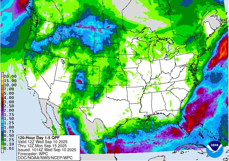
The National Weather Service Weather Prediction Center said there is a “slight risk of excessive rainfall” as a front lingers over the Sunshine State through Friday, Sept. 12.
“Tropical moisture will pool over Florida and the Central Gulf Coast, aiding in the development of showers and thunderstorms that will bring heavy rain to Florida and along the Central Gulf Coast.”
Your Florida weather forecast for today, Sept. 10
Heavy downpours could bring a risk for additional flooding Sept. 10, 2025.
“Wash, rinse and repeat today,” the National Weather Service Melbourne posted on X, warning there is a marginal risk of excessive rainfall Sept. 10.
The National Weather Service Miami warned numerous showers and thunderstorms were expected across most of South Florida this afternoon and into the evening.
“Heavy downpours with high rainfall rates could lead to additional flooding this afternoon especially across the east coast metro areas.”
One to two inches of rain is expected this afternoon, but “there is a 1 in 10 chance of 3-4+ inches where multiple rounds of heavy downpours occur.”
“Most of the Florida Peninsula will pick up 1-3 inches of rain from Monday through Friday, Sept. 12. Some areas may receive 3-6 inches with locally higher totals,” according to AccuWeather.
Here’s your weather forecast for today across Florida:
-
Pensacola: Sunny, with a high near 87. East wind 10 to 15 mph.
-
Tallahassee: Sunny, with a high near 88. North northeast wind around 10 mph.
-
Jacksonville: Mostly sunny, with a high near 84. Breezy, with a north wind 11 to 15 mph, with gusts as high as 23 mph.
-
Daytona Beach: A chance of showers, then showers and thunderstorms likely after 11 a.m. Partly sunny, with a high near 84. North northeast wind 10 to 15 mph, with gusts as high as 25 mph. Chance of precipitation is 60%. New rainfall amounts between a tenth and quarter of an inch, except higher amounts possible in thunderstorms.
-
Melbourne: Showers and thunderstorms likely, mainly after 5 p.m. Partly sunny, with a high near 88. West wind 5 to 10 mph becoming north in the afternoon. Chance of precipitation is 60%. New rainfall amounts of less than a tenth of an inch, except higher amounts possible in thunderstorms.
-
Port St. Lucie: Showers and thunderstorms likely, mainly after 4 p.m. Partly sunny, with a high near 90. West wind around 5 mph. Chance of precipitation is 60%. New rainfall amounts between a quarter and half of an inch possible.
-
West Palm Beach: Showers and thunderstorms, mainly after 2 p.m. High near 87. Heat index values as high as 101. Southwest wind 6 to 8 mph. Chance of precipitation is 80%. New rainfall amounts between a tenth and quarter of an inch, except higher amounts possible in thunderstorms.
-
Miami: Showers and thunderstorms likely, mainly after 4 p.m. Some of the storms could produce heavy rainfall. Mostly sunny, with a high near 89. Heat index values as high as 103. South wind 6 to 10 mph. Chance of precipitation is 60%. New rainfall amounts between a quarter and half of an inch possible.
-
Naples: A chance of showers and thunderstorms before 1 p.m., then showers likely and possibly a thunderstorm between 1 p.m. and 2 p.m., then showers and thunderstorms likely after 2 p.m. Mostly sunny, with a high near 90. Heat index values as high as 105. West wind 6 to 10 mph. Chance of precipitation is 70%. New rainfall amounts of less than a tenth of an inch, except higher amounts possible in thunderstorms.
-
Fort Myers: Scattered showers and thunderstorms before 1 p.m., then showers likely and possibly a thunderstorm between 1 p.m. and 2 p.m., then showers and thunderstorms likely after 2 p.m. Partly sunny, with a high near 89. Heat index values as high as 99. Light and variable wind becoming west southwest 5 to 8 mph in the morning. Chance of precipitation is 70%. New rainfall amounts between a tenth and quarter of an inch, except higher amounts possible in thunderstorms.
-
Sarasota: Showers and thunderstorms likely, mainly after 4 p.m. Partly sunny, with a high near 87. Heat index values as high as 98. East northeast wind around 8 mph becoming west northwest in the afternoon. Chance of precipitation is 60%. New rainfall amounts of less than a tenth of an inch, except higher amounts possible in thunderstorms.
-
Orlando: Showers and thunderstorms likely, mainly after 3 p.m. Partly sunny, with a high near 87. North northeast wind 5 to 10 mph. Chance of precipitation is 60%. New rainfall amounts between a tenth and quarter of an inch, except higher amounts possible in thunderstorms.
Is more rain in Florida’s weekend forecast? See what’s ahead

-
Panhandle, North Florida: Expect rain chances to gradually diminish throughout the week, although rain chances along the coast are expected to be higher than other locations, according to the Florida Division of Emergency Management.
-
Repeated downpours Sept. 10 could bring localized flash flooding before drier air moves across the Panhandle and into Northeast Florida Thursday.
-
As drier conditions and sunshine return Friday and Saturday, high temperatures will return to the middle 80s to lower 90s, with the warmest temperatures along the Panhandle, approaching the middle 90s at times.
-
Lows are expected to fall into the middle to upper 60s throughout North Florida and the lower 70s closer toward the coasts.
-
-
Peninsula: Expect “unsettled” weather to continue throughout the week, bringing widespread showers and thunderstorms through Thursday, according to the Florida Division of Emergency Management.
-
Tropical moisture ahead of and along the frontal boundary will help to bring heavy and intense downpours that could lead to instances of flash flooding through Thursday.
-
If the system moves offshore, expect drier conditions to move into South Florida. If it stalls over land, rain chances will linger over South Florida. Overall, rain chances will gradually decrease from north to south Friday and Saturday.
-
High temperatures throughout the week will remain in the middle to upper 80s and lower 90s each day. Heat index values will remain in the middle to upper 90s, with portions of South Florida and the Keys reaching the lower 100s through Thursday afternoon.
-
Low temperatures will fall into the middle to upper 70s across Central and South Florida and the lower 80s for the Keys through Thursday night. Low temperatures Friday night and Saturday will fall into upper 60s to middle 70s throughout Central and South Florida upper 70s across the Keys.
-
Weather alerts issued in Florida
Some areas in Florida under drought conditions. See the map.

Follow National Weather Service Mobile on X, formerly known as Twitter
-
Thursday: High 87. Low 72.
-
Saturday: High 88. Low 73.
-
Sunday: High 88. Low. 73.

-
Thursday: High 90. Low 65.
-
Saturday: High 90. Low 65.
Follow the National Weather Service Tallahassee on X, formerly known as Twitter

-
Thursday: High 85. Low 72.
-
Friday: High 85. Low 72. Rain chance 20%.
-
Saturday: High 83. Low 71. Rain chance 30%.
-
Sunday: High 84. Low 70. Rain chance 20%.
Follow the National Weather Service Jacksonville on X, formerly known as Twitter

-
Thursday: High 85. Low 75. Rain chance 40%.
-
Friday: High 85. Low 75. Rain chance 40%.
-
Saturday: High 84. Low 74. Rain chance 40%.
-
Sunday: High 84. Low 74. Rain chance 40%.
Follow the National Weather Service Melbourne on X, formerly known as Twitter
-
Thursday: High 87. Low 77. Rain chance 70%.
-
Friday: High 87. Low 76. Rain chance 60%.
-
Saturday: High 86. Low 75. Rain chance 40%.
-
Sunday: High 87. Low 75. Rain chance 30%.
Follow the National Weather Service Melbourne on X, formerly known as Twitter
-
Thursday: High 88. Low 74. Rain chance 70%.
-
Friday: High 86. Low 73. Rain chance 70%.
-
Saturday: High 86. Low 72. Rain chance 50%.
-
Sunday: High 87. Low 72. Rain chance 40%.
Follow the National Weather Service Melbourne on X, formerly known as Twitter

-
Thursday: High 86. Low 79. Rain chance 80%.
-
Friday: High 83. Low 78. Rain chance 80%.
-
Saturday: High 83. Low 78. Rain chance 50%.
-
Sunday: High 85. Low 78. Rain chance 40%.
Follow the National Weather Service Miami on X, formerly known as Twitter
-
Thursday: High 89. Low 80. Rain chance 70%. Heat index could hit 101.
-
Friday: High 87. Low 78. Rain chance 80%.
-
Saturday: High 86. Low 78. Rain chance 50%.
-
Sunday: High 87. Low 78. Rain chance 40%.
Follow the National Weather Service Miami on X, formerly known as Twitter
-
Thursday: High 90. Low 74. Rain chance 70%. Heat index could hit 100.
-
Friday: High 89. Low 83. Rain chance 60%.
-
Saturday: High 88. Low 72. Rain chance 40%.
-
Sunday: High 89. Low 82. Rain chance 30%.
Follow the National Weather Service Miami on X, formerly known as Twitter

-
Thursday: High 89. Low 74. Rain chance 80%. Heat index could hit 98.
-
Friday: High 86. Low 82. Rain chance 60%.
-
Saturday: High 86. Low 70. Rain chance 40%.
-
Sunday: High 88. Low 71. Rain chance 30%.
Follow the National Weather Service Tampa Bay on X, formerly known as Twitter
-
Thursday: High 87. Low 75. Rain chance 70%.
-
Friday: High 86. Low 74. Rain chance 40%.
-
Saturday: High 87. Low 72. Rain chance 20%.
-
Sunday: High 88. Low 83. Rain chance 20%.
Follow the National Weather Service Tampa Bay on X, formerly known as Twitter
-
Thursday: High 86. Low 73. Rain chance 50%.
-
Friday: High 87. Low 72. Rain chance 40%.
-
Saturday: High 86. Low 71. Rain chance 30%.
-
Sunday: High 87. Low 72. Rain chance 40%.
Follow the National Weather Service Melbourne on X, formerly known as Twitter
Stay informed. Get weather alerts via text
What’s next?
We will continue to update our weather coverage as conditions warrant. Download your local site’s app to ensure you’re always connected to the news. And look for our special subscription offers here.
This article originally appeared on Treasure Coast Newspapers: Florida weather forecast, radar: Rain, below-normal temps for some