Tropical Depression Nine will strengthen into Tropical Storm Imelda and move north-northwest through the Bahamas this weekend, far enough offshore to have marginal weather impacts on Florida’s East Coast.
Then Imelda will approach the Carolinas by Tuesday and should be close enough to bring at least coastal rain and wind impacts there, though a landfall is trending less likely.
The NHC began issuing advisories for Tropical Depression Nine yesterday afternoon, which was located about 50 miles north of eastern Cuba with sustained winds of 35 mph, moving northwest at 7 mph.
Hurricane News: Get the latest hurricane updates and how communities are preparing, responding, and recovering.
➤ Weather alerts via text: Sign up to get updates about current storms and weather events by location
Tropical Storm Warnings are in effect for the central and western Bahamas. A Tropical Storm Watch has been hoisted for Florida’s east coast from the Palm Beach/Martin County line north to the Flagler/Volusia County line. It includes Martin, St. Lucie, Indian River, Volusia and Brevard counties.
A NOAA Hurricane Hunter mission is finding evidence of a better-defined surface circulation, so it’s possible Tropical Storm Imelda could be born this afternoon. The storm was upgraded from a potential tropical cyclone to tropical depression at 11 a.m. Saturday.
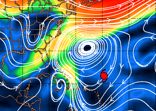
The forecast for what will be Imelda continues to be a tough one, as the system’s movement and intensity will be influenced by four features over the next four days, as seen on water vapor imagery above.
They are: 1) a weak trough of upper-level low pressure over the Florida Straits nudging Imelda north; 2) a stronger mid- and upper-level cutoff low over Georgia and Alabama that will also pull the storm north or north-northwest later this weekend; 3) a subtropical ridge near Bermuda currently pushing Imelda northwest that will slide east and weaken over the next 4 days; and 4) Category 4 Hurricane Humberto, about 1,000 miles away from Imelda northeast of the Lesser Antilles, which will become more influential in a few days as the distance between the two narrows.
Over the next two days, influences 2 and 3 will dominate, and there is good agreement on Imelda angling north-northwest through the western Bahamas over the weekend and then paralleling the Florida peninsula coast through late Monday.
A NOAA 7-day model blend on rain totals shows limited impacts for Florida
With the system’s center likely remaining around 100-150 miles east of Florida’s East Coast, it should be far enough away for the peninsula to avoid significant rain and wind impacts, though I would expect periodic showers with occasional gusts of around 40 mph in squalls for coastal counties through at least Tuesday, as shown on the 06z Euro.
Heavy surf, beach erosion, and rip currents are all expected from coastal Southeast Florida to the Outer Banks no matter the precise outcome with Imelda.
In terms of intensity, southerly shear should be manageable for the next couple of days, allowing Imelda to either be a strong tropical storm or Category 1 by mid-day Monday.
The forecast gets more complicated as Imelda approaches the Carolinas by early Tuesday. The cutoff low will still be attempting to steer the storm northwest, but Humberto’s increasing pull to the southeast will counteract that.
Those influences may well fight to a draw on Tuesday and Wednesday, meaning Imelda will slow down either just inland over the coastal Carolinas or more likely somewhat offshore. Models continue to be split on whether Imelda will eventually nudge inland or pull eastward on Wednesday as Humberto makes its closest approach, but with a stronger trend for Humberto a greater proportion of ensemble members keep Imelda offshore.
Eventually, Humberto may accelerate northeast and leave Imelda behind toward the end of next week, but it’s too early to have much of a sense of whether that second round of potential lingering would happen close enough to the coast to have continued land impacts. Stay tuned.

Current steering currents should keep what will become Tropical Storm Imelda off-shore.
It does appear likely that the initial stall or slow motion will be close enough to bring heavy rainfall and gusty winds to the Georgia and South/North Carolina coasts starting Tuesday, and perhaps persisting through Thursday. (Some coastal flooding is possible as well.)
With shear from the south increasing into mid-week, the heaviest rains will be north and west of the center, meaning that flooding is still a threat in eastern North and South Carolina, though the diminished chance of a quick curl inland lessens the possibility of dangerous rains for central and western Carolinas.
Overall, as of Saturday morning, we still don’t have a great handle on Imelda. The surface circulation is still forming, and the storm will be embedded in a complex environment mashed between many competing influences for the next 5 days. Florida’s East Coast remains unlikely to see major impacts, but the Carolinas should continue to monitor the situation closely as more forecast changes at medium- and long-range are probable.
In the meantime, keep watching the skies.

Ryan Truchelut, WeatherTiger
Dr. Ryan Truchelut is chief meteorologist at WeatherTiger, a Tallahassee company providing forensic meteorology expert witness services and agricultural and hurricane forecasting subscriptions. Visit weathertiger.com to learn more. E-mail Truchelut at ryan@weathertiger.com.
This article originally appeared on Tallahassee Democrat: Florida hurricane forecast tracks Tropical depression, Imelda impacts