East Coast storm to unleash damaging winds, flooding from North Carolina to New York
A developing tropical wind and rainstorm along the Atlantic coast will strengthen while moving northward and deliver damaging winds, major coastal flooding and heavy rainfall on par with a hurricane or powerful nor’easter from Sunday to Tuesday, AccuWeather meteorologists warn.
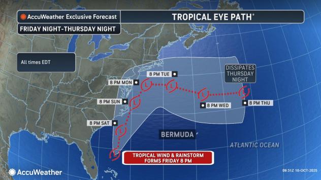
“It is possible this storm may evolve into a sub-tropical or hybrid storm that is part tropical and part non-tropical in nature. If it becomes a subtropical storm, it would be named Lorenzo, as that is the next storm name on the list for the 2025 Atlantic season,” AccuWeather Lead Hurricane Expert Alex DaSilva said.

AccuWeather.com
“This will be a damaging and disruptive storm along the Atlantic coast,” AccuWeather Chief On-Air Meteorologist Bernie Rayno said.
The coast from North Carolina to near New York City will experience significant impacts from the storm, with some damage, power outages and travel disruptions. A narrow zone within this stretch of coast has the potential to experience major damage.
“High winds may impact flights along the coast and lead to airline delays and flight cancellations,” AccuWeather Senior Meteorologist Dave Dombek said. This includes airports around New York City, Boston and Philadelphia.
Outdoor plans during the second half of the weekend and into the start of the new week could be disrupted or canceled across parts of the mid-Atlantic and into southern New England due to expanding rains and increasing winds.

AccuWeather.com
“The AccuWeather RealImpact™ Scale for Hurricanes for this storm is one,” DaSilva said. This scale accounts for all impacts of the storm and ranges from less than one to five.
As the storm strengthens while moving to the north, near the coast, east to northeast winds will increase to the point where gusts frequenting 40-60 mph are in store with an AccuWeather Local StormMax™ gust of 80 mph. A Category 1 hurricane on the Saffir-Simpson Wind Scale has winds of 74 mph or greater.
Winds this strong will lead to power outages, fallen trees and property damage. Loose items may become projectiles.

AccuWeather.com
The wind direction and speed will push a significant amount of water from the Atlantic Ocean toward the coast and into the back bays and estuaries.
A broad zone where a storm surge of 1-3 feet is anticipated will extend from the Carolinas to southeastern New England. However, there will be pockets with a storm surge of 4-5 feet in some beach communities and over the back bays.

AccuWeather.com
It is possible that this storm’s storm surge could rival that of Sandy in some areas, especially in locations in the mid-Atlantic that were spared in the 2012 storm.
The AccuWeather Local StormMax™ surge is 6 feet for this event. The storm surge is water levels above the routine forecast tides in the absence of a storm. Waves along the beachfront and inlets on top of the surge will result in even higher water levels.

AccuWeather.com
Water levels this high will make some roads impassable, inundate the first floor of some neighborhoods, and damage vehicles parked in flooded areas. Access to some communities may be blocked by high water, which will be worse at times of high tide.
Low tide levels during the height of the storm may be above normal high tide levels in many cases.
Seas will reach 25 feet well offshore and pose danger for small craft and could damage larger vessels. Twenty-five feet is approximately the height of a three-story building.

AccuWeather.com
Dangerous surf conditions will exist from the Carolinas to southeastern New England, with frequent and strong rip currents and large, pounding breakers. The combination of high water levels and heavy surf will lead to moderate to major beach erosion.
The combination of high winds and rough seas may temporarily stop some ferry operations and close high bridges for safety concerns.
This storm will bring heavy rainfall along the coast, complicating the flooding situation, even in areas that are abnormally dry or experiencing significant drought.

AccuWeather.com
From 1-4 inches of rain is forecast to fall from coastal South Carolina to southern New England. Within this zone, the AccuWeather Local StormMax™ rainfall is 10 inches and most likely to occur from the North Carolina coast to the New Jersey coast.
“The storm is forecast to stall along the coast and may drift inland for a time or loop around before heading out to sea on Tuesday,” DaSilva said. “During this maneuver, not only will winds, waves and coastal flooding blast away at the coast, but downpours may overwhelm some storm drains and lead to urban flooding.”

AccuWeather.com
Minor to moderate problems associated with wind, storm surge and coastal erosion are anticipated along the southern coast of New England, with the most significant impacts in southwestern Connecticut and in Cape Cod and the islands of Massachusetts.
Want next-level safety, ad-free? Unlock advanced, hyperlocal severe weather alerts when you subscribe to Premium+ on the AccuWeather app. AccuWeather Alerts™ are prompted by our expert meteorologists who monitor and analyze dangerous weather risks 24/7 to keep you and your family safer.