LIVE UPDATES: Flood watch, tornado warnings as storms arrive in Minnesota originally appeared on Bring Me The News.
A flood watch has been issued for an area of Minnesota that includes the Twin Cities, with “slow-moving” thunderstorms on Sunday evening.
The National Weather Service has issued a watch that is in effect in western, central and southern Minnesota from 7 p.m. Sunday to 7 a.m. Monday, and in the Twin Cities, southeastern Minnesota, and western Wisconsin from 10 p.m. to 10 a.m.
Between 1 and 2 inches of rain is expected in the watch area, with “localized amounts of 4 inches or more likely,” while severe thunderstorms and tornado threats are also a possibility.
Scroll down for the latest weather updates.
NWS Twin Cities
7:50 p.m. Heavy rain arrives in Twin Cities
A pocket of heavy rain has just passed over Lake Minnetonka and is making its way northeast. Another line appears to be forming behind it and will follow a similar track.

Accuweather
Further rain is expected to arrive before midnight, with system expected to pass on a line from Mankato through the Twin Cities, and another arriving in west-central Minnesota from the Dakotas and moving through St. Cloud, Brainerd and Bemidji.
8:45 p.m. Flash flooding potential very real
Here’s acclaimed Minnesota meteorologist Paul Douglas on the sheer scale of the rain facing parts of Minnesota with tonight’s rains.
8:25 p.m. Severe thunderstorm warning in Mankato
Up to 60 mph winds and pea-sized hail is possible in the Mankato area.
Here’s some footage of the storm rolling in.
8:00 p.m. View from tornado-warned Waldorf
Minnesota storm chaser Tanner Charles posted this image showing the skies near Waldorf, which is currently under a tornado warning.
7:35 p.m. Severe thunderstorm warnings start
The system that is expected to drop several inches of rain tonight is now turning severe, with 60 mph wind gusts possible in the St. James, Madelia and Butterfield area until 8:15 p.m.
Another tornado warning has now been issued for Faribault and Waseca counties, with Minnesota Lake, Waldorf, and Easton under threat.
7:20 p.m. Tornado warnings in southern Minnesota
Radar-indicated tornado warnings have been issued in southern Minnesota, impacting the Frost, Minnesota, area until 7:30 p.m., and the Winnebago area until 8 p.m.
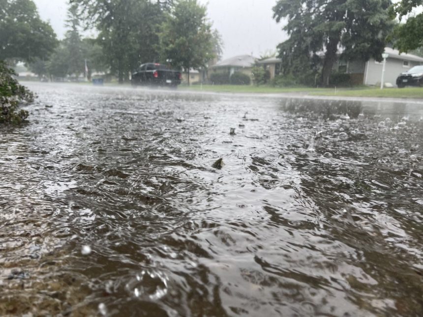
6 p.m. – Flash flooding potential
Officials say that flash flooding is a serious possibility, saying: “Soils, and local streams & creeks are already saturated after heavy rains since Friday, so any rainfall tonight could quickly begin to runoff and lead to flooding.”
The Twin Cities metro was hit by up to 4 inches of rain between separate storms on Friday and Saturday, while southern Minnesota saw more than 4 inches of rain from a stalled storm system early Sunday morning.
“Excessive runoff may result in flooding of rivers, creeks, streams, and other low-lying and flood-prone locations,” the flood watch advisory. “Area creeks and streams are running high and could flood with more heavy rain.”
In its forecast discussion, the NWS Twin Cities says the storm will be moving at 20-25 mph or less, with rain falling at rates of 2-inches per hour in the hardest hit areas.
As of Sunday afternoon there was still uncertainty over where the heaviest rain will happen, but the NWS forecast discussion says “nearly all high-resolution models depict localized amounts of 4+ where they have the heaviest thunderstorms.”
“This leads to higher confidence in the potential for heavy rain and flooding tonight, even if we wont know exactly where until storms fire this evening,” it adds.
It’s also possible that some of the storms making their way through the state on Sunday turn severe, with damaging wind gusts the primary hazards, but hail also possible.
This story was originally reported by Bring Me The News on Aug 17, 2025, where it first appeared.