A complex weather dance is underway in the central Atlantic Ocean this week as a pair of developing tropical systems try to get their act together.
“There are two tropical waves moving through the Atlantic that may develop this week,” said AccuWeather lead hurricane expert Alex DaSilva in an email to USA TODAY.
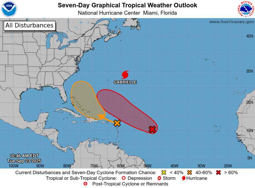
Neither is a named storm yet, so the two systems are dubbed “Invest 93L” and “Invest94L” by the National Hurricane Center.
Although the peak of the 2025 Atlantic hurricane season may have arrived later than the historical average, activity is clearly ramping up, forecasters warned Sept. 23.
The developing systems come against the backdrop of what’s been a quiet season so far, with no hurricane landfalls in the U.S. this year. The season’s second hurricane, Gabrielle, continues to roar far out to sea on its way to Europe.
Atlantic systems on the move
“The two waves we’ve been tracking are now tagged as Invest 93L (the eastern one, which looks a little more robust) and Invest 94L (western one). Still a lot of uncertainty as to how these systems will interact,” Andrew Hazelton, an associate scientist at the University of Miami’s Cooperative Institute for Marine and Atmospheric Studies, said on X Sept. 23.
“93L seems fairly likely to become a recurving hurricane similar to Gabrielle. 94L will take a more westerly track and could pose a threat to the East Coast, but it’s not clear how strong it will get due to interaction with the islands,” Hazelton said. “And of course these waves are close enough that we could see direct and/or indirect interaction between them. Complicated forecast!”
In addition to Hurricane Gabrielle, forecasters are watching two other tropical waves in the Atlantic. The red x is called “Invest93L,” while the orange x is “Invest94L.”
Atlantic hurricane forecast contains an ‘utter mess’
The upper air pattern in the southwest Atlantic is “an utter mess,” which means forecast uncertainty increases dramatically, said Houston-based meteorologist Matt Lanza in his Substack “The Eyewall” on Sept. 23.
“The whole pattern bears watching for the East Coast over the next week or so,” he said. “But uncertainty is extremely high, with a lot happening over a small area and any one feature having impacts on the others.”
“Folks on the East Coast from Florida through New England should monitor the progress of these systems in the next few days to see if we can pull a signal out of this. Because right now, we can’t.”
Hurricane Gabrielle exits the scene
“Hurricane Gabrielle remains impressive as a Category 4 storm in the central North Atlantic,” said Weather Trader meteorologist Ryan Maue in a Substack post Sept. 23.
“While Gabrielle could bring blustery conditions to the Azores by late Thursday and early Friday, it’s too soon to know whether it will pass over or just north of the Portuguese islands,” noted WPLG-TV hurricane specialist Michael Lowry in a Substack post. “Models for now suggest a more direct threat to the less populated northern islands like Flores Island and Corvo Island for late week.”
Lanza said that “it’s still a bit too soon to say how it will impact Europe, but it’s possible a remnant low approaches Portugal by early next week.”
US impacts from Gabrielle
United States impacts from Gabrielle include rough surf and dangerous swimming conditions for the East Coast.
“Swells generated by Gabrielle will continue to affect Bermuda, the U.S. East Coast, and Atlantic Canada over the next few days,” the National Hurricane Center said. “These swells are expected to produce life-threatening surf and rip current conditions.”
The National Weather Service in Melbourne, Florida, warned that “at the beaches, a high risk of life-threatening rip currents continues due to swell from distant Major Hurricane Gabrielle. Entering the surf is not advised.”
This article originally appeared on USA TODAY: Hurricane forecast near US uncertain this week