Hurricane Erin is forecast to grow in size, and that will generate dangerous high surf and rip currents along the entire Eastern Seaboard. It also could push tropical storm winds and surge flooding in parts of North Carolina and the Virginia Tidewater.
(MORE: Erin Maps Tracker – Spaghetti Models, Forecasts, More)
Where Erin Is Now
Erin’s center is currently just over 700 miles south-southeast of Hatteras, North Carolina, moving northwest.
While its maximum sustained winds may not be as extreme as they were the past several days, it remains a powerful hurricane. Just as importantly, though, the size of Erin’s tropical-storm- and hurricane-force winds has increased dramatically since last weekend, as expected.
Overnight, winds gusted to 53 mph in the Turks and Caicos, a group of islands southeast of the Bahamas, according to the National Hurricane Center.
Current Wind Field
Watches And Warnings
Tropical storm and storm surge watches have been issued for the Outer Banks of North Carolina from Beaufort Inlet to Duck, North Carolina, including Pamlico Sound. This means tropical storm conditions and storm surge flooding are possible within the next 48 hours.
Tropical storm warnings and watches remain in effect in the Turks and Caicos and parts of the Bahamas, as can be seen in the map below.

Watch, Warnings
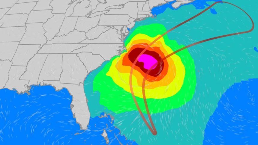
Path, Intensity Forecast
As the forecast path graphic below shows, Erin will curl north, then northeastward between North Carolina and Bermuda and generally south of Atlantic Canada.
Erin is expected to remain a strong hurricane with some fluctuations in intensity possible. While wind shear is expected to cap off any further significant intensification, Erin’s large and growing size means tropical storm force winds in outer rainbands later this week either for the Outer Banks of North Carolina or for Bermuda. We even can’t rule out a few stronger gusts making their way farther up the East Coast into the mid-Atlantic or even southeast New England.
That said, we do not expect Erin’s strongest winds to come anywhere close to the East Coast or Bermuda.

Storm Info And Projected Path
Potential Impacts
-Bermuda, U.S. East Coast: To emphasize, we do not expect the core of Erin’s strongest hurricane winds to affect any part of the U.S. East Coast, nor Bermuda.
But Erin’s large and increasing size means it will generate high surf and dangerous rip currents along the U.S. East Coast much of this week, from Florida to New England.
Of all hurricane hazards, 16% of all fatalities come from rip currents and rough seas. Please stay out of the Atlantic waters this week.
These swells pounding onshore could also lead to some coastal flooding at high tide along parts of the East Coast, particularly in the Carolinas along east or southeast-facing beaches. The NWS office in Morehead City, North Carolina, said parts of Highway 12 in the Outer Banks are at risk of overwash and washouts beginning Tuesday, continuing into at least Thursday. An evacuation of Hatteras Island was already ordered due to this coastal flood threat.
And as alluded to earlier, we can’t completely rule out a brush of tropical storm wind gusts along the Outer Banks of North Carolina or Bermuda in outer rainbands later this week, given Erin’s large size.

Wave Heights Forecast
Erin’s History
Meteorologists first began watching the area of instability that eventually formed Hurricane Erin several days before the storm was named Monday of this past week.
The system remained a tropical storm as it traveled westward across the Atlantic, weakening slightly mid-week as it battled cooler waters.
Thanks to warmer waters in the western Atlantic, Erin began a period of explosive rapid intensification starting on Friday, going from a tropical storm to Category 5 in just under 30 hours, and from a Category 3 to a Category 5 in just under 6 hours.
Erin has also joined a rare group of only five hurricanes that have wind speeds of at least 145 mph by August 16 since 1970, according to Dr. Phil Klotzbach. Erin is the first Category 5 hurricane since Milton and Beryl in 2024.

Erin began to undergo an eyewall replacement cycle on Saturday, setting off a period of fluctuation in intensity and bringing the storm back to Category 4 intensity by Saturday evening.
While Erin has been skirting around islands in the Caribbean, a wind gust of 57 mph was recorded on the island Tortola in the British Virgin Islands Saturday evening, but sustained tropical storm force winds have remained to the north of the islands so far.
Erin dumped up to 6 inches of rain in Puerto Rico and up to 7 inches of rain in the U.S. Virgin Islands, according to the National Weather Service.
Jennifer Gray is a weather and climate writer for weather.com. She has been covering some of the world’s biggest weather and climate stories for the last two decades.