Hurricane Erin rapidly intensified to a Category 5 storm Saturday, Aug. 16, but winds decreased to 125 mph by Sunday morning, Aug. 17. Erin is still a major Category 3 hurricane and growing in size, according to the National Hurricane Center.
Erin is located about 150 miles north of Puerto Rico. The storm’s core is expected to pass to the east of the Turks and Caicos Islands and the southeastern Bahamas tonight and Monday.
A tropical storm warning is in effect for the Turks and Caicos Islands, while the southeastern Bahamas are under a tropical storm watch.
➤ Weather alerts via text: Sign up to get updates about current storms and weather events by location
Hurricane Erin’s outer rainbands are producing gusty winds and heavy rains across the Virgin Islands and Puerto Rico.
The storm is moving toward the west-northwest near 14 mph. A gradual turn to the north is expected on Monday and Tuesday, according to the hurricane center.
This motion should take the core of Erin to the east of the Bahamas on Monday and then roughly midway between Bermuda and the east coast of the U.S. around the middle of the week, NHC forecasters said.
Erin is expected to produce life-threatening surf and rip currents along the beaches of the Bahamas, much of the east coast of the U.S., Bermuda, and Atlantic Canada during the next several days.
Interests along the North Carolina and Mid-Atlantic coasts, and Bermuda should monitor the progress of Erin as there is a risk of strong winds associated with the outer rainbands during the middle part of the week.
Erin is expected to bring dangerous conditions to offshore waters and beaches along the Florida coast from Aug. 18 – 21, including rip currents and rough, high surf with breakers greater than 7 feet on the 19th and 20th, said the weather service office in Jacksonville, Florida.
Officials are encouraging residents to monitor the storm closely and to make sure they’re prepared.
➤ Hurricane drama vs. data: Why Erin is a minuscule threat to Florida, U.S. east coast
Hurricane categories: Saffir-Simpson Hurricane Wind Scale
-
Category 1 hurricane: 74-95 mph
-
Category 2 hurricane: 96-110 mph
-
Category 3 hurricane: 111-129 mph
-
Category 4 hurricane: 130-156 mph
-
Category 5 hurricane: 157 mph or higher
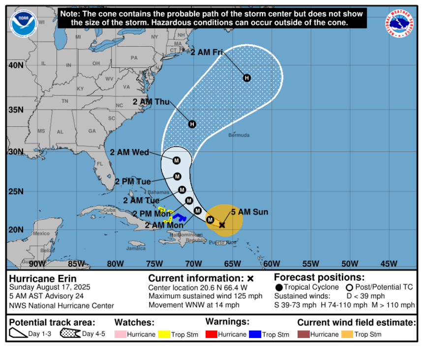
Hurricane Erin update, path
Special note on the NHC cone: The forecast track shows the most likely path of the center of the storm. It does not illustrate the full width of the storm or its impacts, and the center of the storm is likely to travel outside the cone up to 33% of the time.
-
Location: 155 miles north of San Juan, Puerto Rico
-
Maximum sustained winds: 125 mph
-
Movement: west-northwest at 14 mph
Hurricane Erin now a Category 3 storm
Hurricane Erin rapidly intensified to a Category 5 storm Saturday, Aug. 16, but winds decreased to 125 mph by Sunday morning, Aug. 17.
Spaghetti models for Hurricane Erin. Where is the storm going?
Special note about spaghetti models: Illustrations include an array of forecast tools and models, and not all are created equal. The hurricane center uses only the top four or five highest performing models to help make its forecasts.
Is there a hurricane coming to Florida?
No. Erin is moving west. A gradual turn to the north is expected on Monday and Tuesday, according to the hurricane center. The center of the storm is expected to remain east of Florida.
Remember, forecasts can change, so it’s always best to be prepared.

U.S. rip current risk from Hurricane Erin, as of 5 a.m. Aug. 17, 2025.
What impacts could Hurricane Erin have on Florida?
Erin is expected to produce dangerous surf and rip currents along the beaches of the Bahamas, much of the East Coast of the U.S., including Florida, and Atlantic Canada next week.
Erin is expected to bring dangerous conditions to offshore waters and beaches along the Florida coast from Aug. 18 – 21, including rip currents and rough, high surf with breakers greater than 7 feet on the 19th and 20th, said the weather service office in Jacksonville, Florida.
How strong is Hurricane Erin and where could it go? See the scenarios
At 5 a.m., the center of Hurricane Erin was located near latitude 20.6 North, longitude 66.4 West.
Erin is moving toward the west-northwest near 14 mph. This motion with a decrease in forward speed is expected today, followed by a gradual turn to the north on Monday and Tuesday.
On the forecast track, the core of Erin is expected to pass to the east of the Turks and Caicos Islands and the southeastern Bahamas tonight and Monday.
Maximum sustained winds are near 125 mph with higher gusts. Erin is a Category 3 hurricane on the Saffir-Simpson Hurricane Wind Scale. Fluctuations in intensity are expected over the next day or two due to inner-core structural changes.
Erin is growing in size. Hurricane-force winds extend outward up to 25 miles from the center and tropical-storm-force winds extend outward up to 205 miles.
Have any watches or warnings been issued for Hurricane Erin?
A tropical storm warning is in effect for:
A Tropical Storm Warning means that tropical storm conditions are expected somewhere within the warning area, in this case within 24 hours.
A tropical storm watch is in effect for:
A Tropical Storm Watch means that tropical storm conditions are possible within the watch area, in this case within 24 hours.
Interests elsewhere in the Virgin Islands, Puerto Rico, and the central Bahamas should monitor the progress of Erin.
Hazards affecting land from Hurricane Erin
RAINFALL: The outer bands of Erin will continue to produce areas of heavy rainfall today across the Virgin Islands and Puerto Rico. Rainfall totals of 3 to 6 inches, with isolated totals of 8 inches, are expected. Locally considerable flash and urban flooding, along with landslides or mudslides, are possible.
WIND: Tropical storm conditions are expected across the warning area in the Turks and Caicos Islands beginning tonight. Tropical storm conditions are possible in the watch area in the Southeast Bahamas tonight and Monday. Squalls with wind gusts to tropical storm force could occur over portions of the Virgin Islands and Puerto Rico today and across the central Bahamas Monday and Tuesday.
SURF: Swells generated by Erin will continue to affect portions of the Virgin Islands, Puerto Rico, Hispaniola, and the Turks and Caicos Islands during the next couple of days. These swells will spread to the Bahamas, Bermuda, the east coast of the United States, and Atlantic Canada during the early and middle portions of the week. These rough ocean conditions will likely cause life-threatening surf and rip currents. Please consult products from your local weather forecast office for more information.
Key messages from the National Hurricane Center: What you need to know about Hurricane Erin
-
Heavy rainfall is expected to continue across the Virgin Islands and Puerto Rico today. Locally considerable flash and urban flooding, along with landslides or mudslides, are possible.
-
Tropical storm conditions are expected in the Turks and Caicos Islands and are possible in the Southeast Bahamas tonight and Monday. Gusts to tropical storm force are possible in Erin’s outer rainbands in portions of Puerto Rico today and the central Bahamas on Monday and Tuesday.
-
Erin is expected to produce life-threatening surf and rip currents along the beaches of the Bahamas, much of the east coast of the U.S., Bermuda, and Atlantic Canada during the next several days.
-
Interests along the North Carolina and Mid-Atlantic coasts, and Bermuda should monitor the progress of Erin as there is a risk of strong winds associated with the outer rainbands during the middle part of the week.
Current forecast: How strong could Hurricane Erin get?

National Hurricane Center tracking 2 other systems in the Atlantic
Northwestern Atlantic: The area of low pressure located a couple hundred miles off the coast of North Carolina continues to produce disorganized shower activity to the east of the center. Development, if any, of this system should be slow to occur during the next day or so while it moves little over the warm waters of the Gulf Stream. The opportunity for development should end on Monday when environmental conditions are expected to become unfavorable.
-
Formation chance through 48 hours: low…10 percent.
-
Formation chance through 7 days: low…10 percent.
Central Tropical Atlantic: An area of low pressure could form over the central tropical Atlantic during the middle to latter portion of the week. Some subsequent development could occur as the system moves westward to west-northwestward at 15 to 20 mph.
-
Formation chance through 48 hours: low…near 0 percent.
-
Formation chance through 7 days: low…20 percent.
Interactive map: What tropical storms, hurricanes have impacted your area in the past?
Stay informed. Get weather alerts via text
What’s next?
We will update our tropical weather coverage daily.
Download your local site’s app to ensure you’re always connected to the news. And look for our special subscription offers here.
This article originally appeared on Naples Daily News: Hurricane Erin path tracker, location now. Florida impact