Humberto wasted no time strengthening and is now a hurricane in the southwestern Atlantic.
The National Hurricane Center is forecasting Humberto will continue growing stronger and become a Category 4 storm over the weekend, according to its 5 a.m. advisory.
➤ Weather alerts via text: Sign up to get updates about current storms and weather events by location
“Humberto is showing signs of steady-to-rapid intensification,” the Hurricane Center said as it increased its intensity forecast Friday morning.
Maximum sustained winds are now expected to hit 130 mph in 60 hours, making Humberto a Category 4 major hurricane. A major hurricane is one that’s at least a Category 3 or higher storm, with sustained winds of at least 111 mph.
If Humberto does strengthen into a major hurricane, it will be the third hurricane this year to do so. Both Erin and Gabrielle — the only hurricanes so far this year — not only became hurricanes, but rapidly intensified into major hurricanes.
The last time an Atlantic hurricane season’s first three hurricanes were major was in 1935, according to Philip Klotzbach, meteorologist at Colorado State University specializing in Atlantic basin seasonal hurricane forecasts.
Here’s what you should know about Hurricane Humberto.
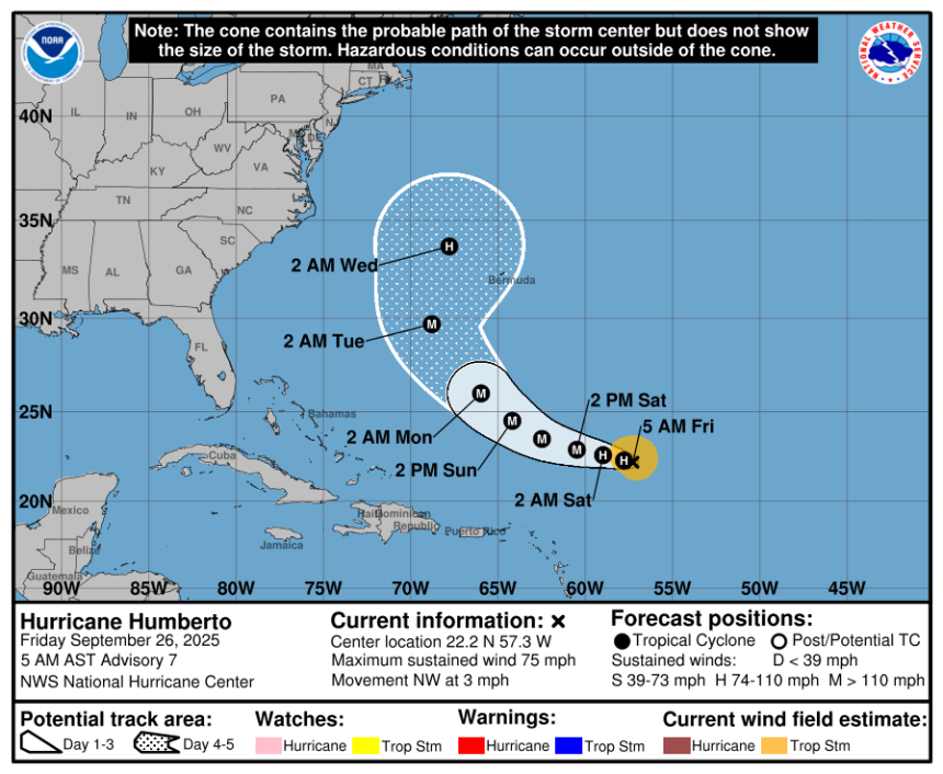
Quick look on what Hurricane Humberto is doing now
Special note on the NHC cone: The forecast track shows the most likely path of the center of the storm. It does not illustrate the full width of the storm or its impacts, and the center of the storm is likely to travel outside the cone up to 33% of the time.
-
Location: 465 miles northeast of the Northern Leeward Islands; 1,462 miles east of West Palm Beach
-
Maximum sustained winds: 75 mph
-
Movement: northwest at 3 mph
Hurricane Humberto expected to continue strengthening
At 5 a.m., the eye of Hurricane Humberto was located near latitude 22.2 North, longitude 57.3 West.
Humberto is moving toward the northwest near 3 mph. A slow west-northwest to northwest motion is expected during the next couple of days.
Maximum sustained winds have increased to near 75 mph, with higher gusts.
Significant strengthening is forecast, and Humberto is expected to become a major hurricane this weekend.
Hurricane-force winds extend outward up to 10 miles from the center and tropical-storm-force winds extend outward up to 105 miles.
The estimated minimum central pressure is 990 mb.
Spaghetti models for Hurricane Humberto
Special note about spaghetti models: Illustrations include an array of forecast tools and models, and not all are created equal. The hurricane center uses only the top four or five highest performing models to help make its forecasts.
See watches, warnings issued in Florida ahead of Hurricane Humberto
As of 5 a.m. Sept. 26, no watches or warnings associated with Hurricane Humberto have been issued.
Is there a hurricane coming toward Florida? What impacts could Humberto have?
The forecast for Hurricane Humberto and its possible impact on Florida and the United States are difficult to predict because of something called the Fujiwhara effect.
➤ Fujiwhara effect making it hard to figure out Florida impacts of Humberto, Invest 94L. What is it?
Invest 94L east of Humberto is expected to strengthen and could become Tropical Storm Imelda.
Interaction between the two is known as the Fujiwhara effect and that rare and “highly complex” setup is making it hard for forecasters to predict where they two could go and how strong they could become.
Current forecasts put Humberto passing west of Bermuda and east of the U.S. coast.
“We expect Humberto to track well off the coast of the U.S. but bring some wind and rain to the islands of Bermuda early next week,” said AccuWeather lead hurricane expert Alex DaSilva.
AccuWeather brought up some possible scenarios:
-
Interaction between Humberto and what’s now Invest 94L could pull what is expected to become Imelda away from the U.S. or steal its moisture, limiting rain impacts in the southeastern U.S.
-
If the two storms remain separate or there is minimal interaction, Imelda could make landfall in the Carolinas early next week with damaging winds, coastal flooding, erosive waves and flooding rainfall.
-
In a worst-case scenario, heavy rain from both tropical and non-tropical origins could bring prolonged, tremendous rain and flooding to parts of the Carolinas and Georgia.
Indirect impacts to Florida and the U.S. east coast are easier to predict.
“Regardless of whether a hurricane makes landfall in the southeastern U.S. or not, strong winds will create large, chaotic swells that will propagate toward the southern and middle Atlantic coast late this weekend to the middle of next week,” AccuWeather said.
“Large, frequent breakers will create strong rip currents and lead to beach erosion.”
Key messages from the National Hurricane Center: What you need to know about Hurricane Humberto
-
Humberto has become better organized, with hints of an eye-like feature near the center.
-
Humberto is expected to gradually increase speed while moving west-northward to northwest.
-
Humberto is showing signs of steady-to-rapid intensification.
-
Humberto is forecast to become a major hurricane this weekend.
Current forecast: How strong could Hurricane Humberto get?
Interactive map: What tropical storms, hurricanes have impacted your area in the past?
Stay informed. Get weather alerts via text
What’s next?
We will update our tropical weather coverage daily.
Download your local site’s app to ensure you’re always connected to the news. And look for our special subscription offers here.
This article originally appeared on Fort Myers News-Press: Hurricane Humberto could become major hurricane