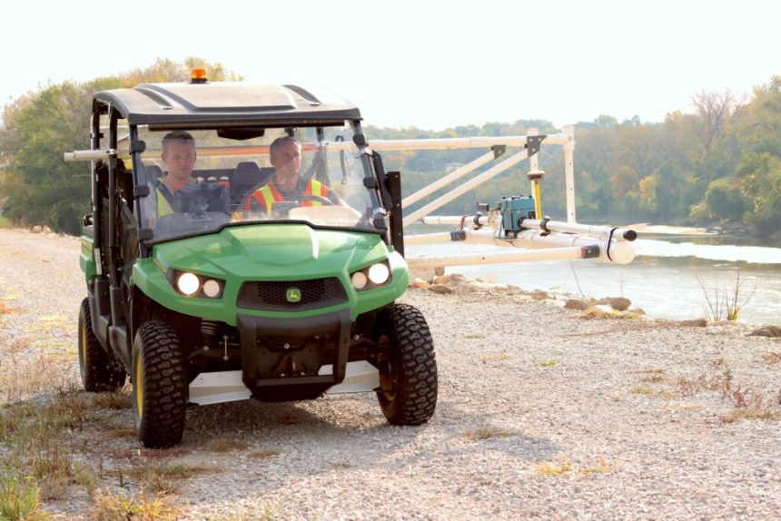
Jason Vogelgesang, right, and Thomas Doyle drive along a levee by the Raccoon River in Des Moines to survey the geology of the levee. (Photo by Cami Koons/Iowa Capital Dispatch)
Drive across the top of the levee; come back along the levee’s “toe” slope; pause when a flood wall or obstruction crosses the levee; move to the next section.
This has been the methodology for the Iowa Geological Survey team members the past several fall seasons as they survey the geological integrity of Iowa’s 900 miles of levees.
The crew is on year three of a five-year, legislatively directed initiative to assess levees across the state to help the state Office of Levee Safety to prioritize funding for repairs on the structures that help prevent flood damage.
Jason Vogelgesang, a geophysicist with Iowa Geological Survey, said the data collected with the survey helps to point out specific areas of a levee in need of repair, which can help to lower the cost to fix a levee.
“What we’re trying to do out here is find anomalous areas, or different areas, in the levees that could be a potential area of weakness,” Vogelgesang said.
He said this way, rather than tearing out an entire levee, a levee system can instead focus repairs to the areas that, based on geological data, could be more susceptible to failure in a flood event.
SUBSCRIBE: GET THE MORNING HEADLINES DELIVERED TO YOUR INBOX
How the survey works
Vogelgesang and his colleague Thomas Doyle, also with the Iowa Geological Survey based at the University of Iowa, head out a couple of times a week during the fall, when the levees are usually mowed and accessible, to drive along the systems.
The U.S. Army Corps of Engineers defines a levee as “an earthen embankment, floodwall, or structure along a water course whose purpose is flood risk reduction or water conveyance.”
To start the surveying day, the crew rig up a set of PVC pipes on a side-by-side utility vehicle. A ground conductivity meter is then strapped to the PVC, which keeps the vehicle a safe distance from the meter and prevents it from interfering with the meter’s metal readings.
Vogelgesang said the meter is actually meant to be strapped over a shoulder and carried, but the Iowa Geological Survey team created the rig on the vehicle to more efficiently survey the hundreds of miles of levee systems across the state.
“It’s kind of an innovative method of collecting these data,” Vogelgesang said.
Jason Vogelgesang, left, and Thomas Doyle set up the ground conductivity meter that allows them to survey the geology 20 feet below the surface of a levee. (Photo by Cami Koons/Iowa Capital Dispatch)
As he drives along the top of the levee, the meter sends an electrical current that penetrates the subsurface before it comes back up to the meter’s receiver. The current changes as it pass through the ground, which is how the geological team is able to determine the makeup of the subsurface.
The meter sends five readings per second, which are automatically collected via Bluetooth on a tablet inside the side-by-side.
The current travels 20 feet down, which Vogelgesang said shows his team “pretty much the whole swath of the levee.”
After driving along the top of the levee, the crew turns around and drives back along the levee’s “toe slope” or base of the embankment in the floodplain.
Vogelgesang said driving along the toe slope collects data on the geology below the levee, which can reveal things like a deposit of coarse sand, or a forgotten metal culvert, both of which could allow water to flow through if there were enough hydrological pressure.
When it comes to levee structures, and geological features below the levee, compact materials like clay are more secure. Sand- and gravel-based levees — which Vogelgesang said he has come across while doing the survey project — could be more likely to fail in the event of a flood.
Vogelgesang’s and Doyle’s Friday trip to Des Moines was the second time they had surveyed levees in the capital city. While they spent their day surveying about 10 miles of levees along the Raccoon River, Vogelgesang said two years ago, they surveyed levees along the eastern side of the Des Moines river.
Each year, the team aims to survey about 200 miles of levees. Vogelgesang said it takes a significant amount of legwork, before he shows up on site with the side-by-side to map the levees, figure out where obstructions could be and get permission from the cities and levee districts.
After the levees have been driven, Vogelgesang and his team spend the winter and spring processing and analyzing the thousands of generated data points. Each levee system, which encompasses the levees in the a given region or city, will receive a report from the geological survey about their levees.
Vogelgesang said these reports are also due to the Iowa Office of Levee Safety.
The office uses the geological findings to rate the levees on a scale of 1 to 5, with 5 meaning the levee has a “critical need for repair” and 1 meaning the levee is “optimal,” according to the office.

A tablet inside the vehicle receives and charts the data from the meter on the side of the side-by-side. (Photo by Cami Koons/Iowa Capital Dispatch)
Iowa Levee Improvement Program
The geological survey of the levees, the Office of Levee Safety and a Levee Improvement Fund, which has an annual appropriation of $5 million from 2024 through 2028, were created in 2023 with the enactment of House File 711.
These programs comprise the Iowa Levee Improvement Program, which according to the 2024 Iowa Levee Safety report, has a goal of reducing and managing the risks associated with “a hazardous event caused by inadequate levee design, structural performance, or operational control.”
Under the program, levee districts can apply for cost-share funding to improve their levee systems. The levee ratings, issued by the Office of Levee Safety and informed by Vogelgesang’s surveys, are considered when the Iowa Flood Mitigation Board issues the funds.
Levee improvement program was established after a 2022 study found that “the current approach of managing and financing levee districts within the state of Iowa is unsustainable.”
The Iowa Levee Improvement Program is a step toward improving the state of Iowa’s levee structures, which help to control flooding events.
So far, the Iowa Geological Survey has driven and collected data on more than 300 miles of Iowa levees and will be over halfway done surveying at the end of the season.
The Office of Levee Safety has held several town halls, established the levee rating system and generated partnerships across levee districts to develop a “unified approach to flood risk management” according to the annual report.
“We are committed to continuous improvement, leveraging data-driven insights to enhance our initiatives and reinforce our response to flood events,” the annual report read.