The United States will probably experience several months of La Niña, the weather pattern that brings unexpected winter weather through Oklahoma.
Climate meteorologists have forecast a 71% chance of La Niña developing between October and December 2025.
La Niña, along with its “brother” weather pattern El Niño, are natural patterns of Pacific Ocean temperature changes that cause wide-reaching impacts across North America.
What is La Niña?
La Niña is part of the weather phenomenon known as El Niño Southern Oscillation, which is the changing of surface temperatures in the Pacific Ocean, according to the Farmers Almanac. During El Niño conditions, sea temperatures are unusually warmer near the Equator.
La Niña has the opposite effect, with unusually cold waters in the same area. The weather pattern, which means “the little girl” in Spanish, occurs every three to five years and typically lasts between nine to 12 months.
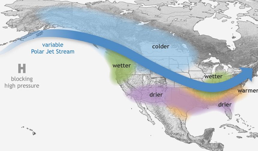
La Niña causes the jet stream to move northward and to weaken over the eastern Pacific. During La Niña winters, the South sees warmer and drier conditions than usual. The North and Canada tend to be wetter and colder.
How does La Niña affect Oklahoma?
The variation in surface temperatures is often smaller than one degree (in Celsius) off normal, but the impacts are huge.
La Niña usually means warmer and drier weather in the South and Southwest United States. Meanwhile, areas like the northwestern United States will see cooler and wetter conditions.
Oklahoma tends to be warmer and drier than normal when La Niña is prevailing. A moderately strong but lengthy La Niña period between 2020 and 2023 was a rarity for the usually short-lived phenomenon. It created devastating drought conditions throughout Oklahoma, with one of the worst wheat harvests the state had seen in years.
This article originally appeared on Oklahoman: La Nina weather pattern could bring a mild winter to Oklahoma in 2025