Isolated severe storms will be possible through tonight, and a tornado watch continues for several counties in north Alabama.
The watch will be in effect until 10 p.m. for parts of Alabama, Tennessee and Kentucky.
The Alabama counties in the watch are Lauderdale, Limestone, Madison and Jackson.
The Storm Prediction Center said a tornado will be possible in the watch area, as well as scattered damaging winds as high as 70 mph and isolated large hail.
Storms were moving through parts of Tennessee on Friday night, and those were expected to push southward and eastward through the night.
But they were taking their time:
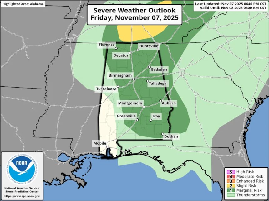
NOAA’s Storm Prediction Center is continuing to forecast a Level 1 out of 5 (marginal) risk for severe weather on Friday for all but southwest Alabama.
A Level 1 risk means that isolated severe storms will be possible.
This will be the only risk for severe weather this week for Alabama; a severe weather risk for Saturday has been dropped by forecasters.
Thunderstorms will be possible on Saturday for the southern two-thirds of the state, but they are not expected to be severe.
Here is the updated severe weather forecast for Saturday:
As far as tonight, the National Weather Service will watch two areas of storms: One in south-central parts of the state and another batch of storms north of Alabama in Tennessee that were pushing southward.
Rain chances will continue into Saturday. However, the weather service expects rain totals to be on the lighter side.
Some spots could get a half-inch of rain through Sunday, but most areas will get less.
Here is the forecast for rainfall through Sunday:
The coldest air of the fall is expected to follow Saturday’s rain, with much colder temperatures expected to be felt starting on Sunday night.
The weather service thinks some record low temperatures will be possible, especially Monday night into Tuesday morning.
Temperatures will drop to freezing or below, and freeze warnings will likely be issued, according to forecasters.
A freeze will be possible in north and north-central Alabama Sunday night into Monday morning, and a more widespread freeze looks likely starting Monday night and into Tuesday morning that could reach all the way into south Alabama.
Here’s a look at timing for today’s potential storms from the weather service:
NORTH ALABAMA
CENTRAL ALABAMA
SOUTH ALABAMA
Read the original article on al.com.