After a relatively quiet wildfire season, a spate of lightning storms has ramped up the number of fires across Oregon to the highest so far this season.
The good news is that incoming rain and cooler temperatures should help firefighters fighting blazes in southwest Oregon’s Rogue River, across the Cascade Range and in central and eastern Oregon.
“We’re hoping this is a turning point and that the rain shows up, the temperatures drop and it’s a big help to our firefighters, but it hasn’t happened yet,” Oregon Department of Forestry fire spokeswoman Jessica Neujahr said.
Here’s a roundup on the major fires burning around the state.
Emigrant Fire: As rain arrives, air quality should improve
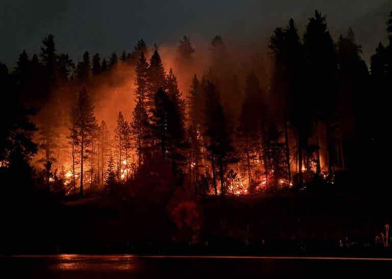
Cooler and wetter weather is letting firefighters get a leg up on the Emigrant Fire, which has burned 32,294 acres as of Sept. 8.
With the mild weather, fire personnel will be focused on cutting hazard trees and mopping up hot spots near the fire perimeter.
The Emigrant Fire, 21 miles southeast of Oakridge in Lane and Douglas counties, has burned 32,294 acres as of Sept. 8.
Sprinklers are in place along the hydroelectric project flumes and trestles near Forest Service Road 78 to protect this part of the power grid, if the fire starts to move further south, an update said.
Cool weather, thunderstorms and showers are expected throughout the day and into Sept. 9.
Air quality is expected to improve over the next few days.
Rogue River wildfires impacting rafting, fishing on iconic river
Three major wildfires are burning along southwest Oregon’s Rogue River, including the 3,000-acre Moon Complex near Paradise and Half Moon lodges, east of Gold Beach and west of Grants Pass. The good news is that both lodges are in good shape and still standing, fire officials said the morning of Sept. 8.
The other fire is the 918-acre Kelsey Peak Fire. The river remains open to those with permits to float the iconic river, but some campgrounds, lodges and segements of the Rogue River Trail remain closed.
Multiple small fire starts in Oregon’s Cascade Mountains

The Yamsay Fire continues to burn 5 miles northeast of Yamsay Mountain in Lake County.
Numerous wildfires have ignited in the Cascade Mountains, including Willamette and Deschutes national forests. They include:
-
The Foley Ridge Fire burning in the Willamette National Forest on the McKenzie River Ranger District was estimated to be burning at 20 acres as of Sept. 7. Crews were scouting locations for containment line and utilizing direct tactics along the fire’s edge where possible, an update said.
-
The 369 Fire in the Sweet Home Ranger District was burning at 10 acres as of Sept. 7.
-
The Yamsay Fire burning 5 miles northeast of Yamsay Mountain in Lake County was 6 acres and 100% lines as of Sept. 7.
-
The Coyote Fire in Douglas County was estimated to be burning at 14 acres as of Sept. 8.
-
The Big Hole Fire in the Deschutes National Forest was estimated to be burning at 54.5 acres and is 25% contained as of Sept. 7. The fire is expected to be contained on Sept. 9, the Central Oregon Fire Information website said.
-
The Ma #27 fire was reported on Sept. 7 on the 3800 Block of The Dalles-California Highway in Klamath County and was estimated to be 5 acres.
-
The Carlson Creek Fire was reported on Sept. 7 in Harney County and was estimated to be 16 acres as of Sept. 8.
Multiple fires continue to burn within and east of the Oregon Cascades
The lighting-caused Black Rock Fire had burned 40,684 acres, 5 miles northeast of Clarno, as of Sept. 8, according to the Central Oregon Fire Information website. Rainfall and increased moisture have helped slow the spread of the fire.
Fire personnel will continue to focus on fire suppression, but the fire is burning in rural terrain that is hard to access.
Evacuation levels 1, 2 and 3 remain in effect for areas in Wasco, Sherman, Wheeler and Gilliam counties. An evacuation map can be found out bit.ly/4ncoe8R.
Temperatures were forecast to be in the 80s Sept. 8 with wet patterns, rainfall and possible thunderstorms.
Marks Creek Fire 18% contained in Crook County
The Marks Creek Fire off of Ochoco Highway near Marks Creek in Crook County has burned 1,718 acres and was 18% contained as of Sept. 8.
Firefighters will continue to work on mop up operations from the evening of Sept. 7, and work to increase the depth of containment around the fire’s edge, an update said.

The Marks Creek Fire continues to burn off Ochoco Highway near Marks Creek in Crook County.
Suppression repair work will begin in areas where the fire has been contained.
Weather for Sept. 8 was forecast to bring rain and a 15%-20% chance of lightning.
Levels 1, 2 and 3 evacuations remain in place. An evacuation map can be found at bit.ly/487Jyr8
Closures continue for the Bridge Fire
The Bridge Fire burning 10 miles northeast of Prairie City had burned 350 acres and was 15% contained as of Sept. 8.
Crews have made significant progress on containment efforts in multiple areas of the fire, an update said. The northeast portion of the fire remains the most active, due to dry fuels and limited precipitation.
“Mop-up and patrol continue along the southeast portion of the fire, while crews in the northern finger are securing handline and reinforcing containment around spot fires,” the update said.
Multiple closures still remain in effect:
-
Starting at the junction of Oregon State Highway 7 and Oregon State Highway 26 (Austin Junction) following State Highway 26 west to the intersection with the National Forest Service (NFS) boundary at T. 12 S, R. 34 E, Sec. 16
-
Following the NFS Boundary west and north to the intersection with National Forest System Road (FSR) 3670
-
Following FSR 3670 north to the junction with FSR 2050
-
Continuing north on FSR 2050 to the junction with Grant County Road (CR) 20
-
Continuing east along CR 20 to the junction with State Highway 7
-
Heading south on State Highway 7 to the junction with State Highway 26 (Austin Junction)
-
Recreation sites included in closure: Deerhorn Campground, Middle Fork Campground, Dixie Campground, Davis Creek Trail #244 and both trailheads.
Evacuation levels 1 and 2 remain in place. An evacuation map can be found at bit.ly/4noOiNv
Mariah Johnston is an outdoors journalism intern at the Statesman Journal. Reach her at mjohnston@gannett.com.
This article originally appeared on Salem Statesman Journal: Oregon wildfire updates: Lightning storms ramp up number of blazes