The National Hurricane Center is monitoring a tropical wave off the coast of Africa that shows an increased chance for development over the next seven days.
A tropical depression could form by the middle part of next week as it moves west or west-northwest across the Atlantic, forecasters said.
➤ Weather alerts via text: Sign up to get updates about current storms and weather events by location
The potential storm comes just after the peak of hurricane season arrived Sept. 10.
It was the “first climatological peak of the Atlantic hurricane season in nearly a decade without a named storm in the basin,” AccuWeather Lead Hurricane Expert Alex DaSilva said.
“No tropical storms or hurricanes over the Atlantic basin on Sept. 10 has only happened three times over the last 30 years,” DaSilva said.
The National Hurricane Center currently is tracking three other tropical waves in the Atlantic basin, which covers the northern Atlantic, Gulf and Caribbean, along with the one expected to move off Africa.
➤ September hurricane season forecast: Savor the break, but trouble is brewing in back half
The next named storm of the Atlantic hurricane season will be Gabrielle.
What tropical waves, disturbances are in Atlantic basin now?
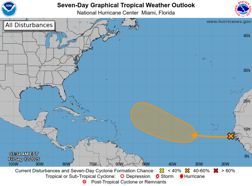
A tropical wave located near the west coast of Africa is producing disorganized showers and thunderstorms over the far eastern Atlantic.
Environmental conditions appear conducive for some gradual development of this system over the next several days.
A tropical depression could form by the middle part of next week while it moves westward to west-northwestward at 10 to 15 mph over the eastern and central tropical Atlantic.
-
Formation chance through 48 hours: low, near 0 percent.
-
Formation chance through 7 days: medium, 40 percent.
More tropical waves:
-
The axis of an eastern Atlantic tropical wave is near 37W from 02N to 20N, moving westward at 11 to 17 mph. Scattered showers and isolated thunderstorms are seen from 15N to 17N between 34W and 40W.
-
The axis of a central Atlantic tropical wave is near 56W south of 19N. It is moving westward at 11 to 17 mph. Increasing numerous moderate to isolated strong convection is from 13N to 16N between 54W and 59W.
-
A western Caribbean tropical wave has its axis near 81W south of 20N moving westward at about 11 mph. Numerous strong convection is behind the wave to along the coast of northwest Colombia and south of 11N.
What do the colored, hatched areas on the NOAA map mean?
The hatched areas on the National Hurricane Center’s tropical outlook map indicate “areas where a tropical cyclone — which could be a tropical depression, tropical storm or hurricane — could develop,” said National Hurricane Center Deputy Director Jamie Rhome.
The colors make it visibly clear how likely a system could develop, with yellow being low, orange medium, and red high.
The National Hurricane Center generally doesn’t issue tropical advisories until there is a named storm, but there is an exception.
“If a system is near land and there is potential for development, the National Hurricane Center won’t wait before it issues advisories, even if the system hasn’t become an actual storm. This gives residents time to prepare,” Rhome said.
Colorado State University predicting tropics to become more active

Atlantic named storm formations from Sept. 3 to Sept. 16 from 1966 to 2024 and the maximum intensity that these named storms reached.
In its two-week forecast for Sept. 3-16, Colorado State University forecasters are predicting activity will pick up over the next couple of weeks.
“Global model ensembles are pretty aggressive with additional tropical cyclone development in days 8 through 14, with potential formations in the eastern Atlantic as well as in the western Caribbean/southern Gulf,” the CSU forecast said.
“The primary threat formation area for major hurricanes in early- to mid-September is in the eastern and central tropical Atlantic.”
Is a hurricane coming to Florida?
No. The National Hurricane Center is monitoring four tropical waves but it’s too early at this time to determine if there will be any impact to Florida or the U.S.
Officials warn residents not to become complacent, though, since activity is expected to pick up later this month and conditions that have helped prevent storms from developing — dry air and wind shear — are expected to dissipate.
Of special concern are storms that develop close to the United States.
“Rapid intensification in the Gulf allows less time to prepare compared to storms strengthening in the central Atlantic,” DaSilva said. “The exceptional warmth in the Gulf is troubling.”
Those storms also can rapidly intensify, especially in the extremely warm waters of the Gulf, AccuWeather forecasters warned.
Don’t let your guard down. Tropical activity expected later this month
“We do anticipate the season picking up, however, given that large-scale conditions appear to become more tropical cyclone-favorable later in September,” Colorado State University said.
AccuWeather’s team of meteorologists expects the second half of the hurricane season to be more active than the first.
“There is a low risk of tropical development off the Southeast coast and in the Atlantic this weekend,” DaSilva said.
“Atmospheric conditions that are more conducive to tropical development are expected to return next week.”
What should be in a hurricane kit? Get supplies without paying sales tax in Florida
Officials regularly encourage Florida residents to prepare for storms before a hurricane is approaching, while shelves are fully stocked and you aren’t battling crowds all rushing to the store at the same time.
“It only takes one storm to make it an impactful year for your community,” the National Hurricane Center Miami posted on X.
➤ See list of emergency supplies you can now buy tax free
On Aug. 1, specific hurricane supplies became permanently tax-free in Florida, ranging from batteries to generators.
➤ Don’t have a hurricane supply kit? From the basics to the extras, here’s what you need
Here are some of the basics you should have:
-
Two-week supply of medications
-
A go-bag with essential supplies in case you need to leave quickly
-
Portable cellphone chargers
-
List of emergency phone numbers, including those for family members
-
Copy of your insurance policy
Florida weather radar for Sept. 12, 2025

Weather watches and warnings issued in Florida
When does hurricane season end in Florida?
The Atlantic hurricane season runs from June 1 through Nov. 30.
Ninety-seven percent of tropical cyclone activity occurs during this time period, NOAA said.
The Atlantic basin includes the northern Atlantic Ocean, Caribbean Sea and Gulf of America, as the Gulf of Mexico is now known in the U.S. per an order from President Trump. NOAA and the National Hurricane Center are now using Gulf of America on its maps and in its advisories.
When is peak hurricane season?

Hurricane season’s ultimate peak is Sept. 10 but the season goes through Nov. 30. Credit: NOAA
The peak of the season is Sept. 10, with the most activity happening between mid-August and mid-October, according to the Hurricane Center.
Hurricane names for 2025 season
Here are the names for the 2025 Atlantic hurricane season, along with how to pronounce them. The first hurricane of the season typically forms Aug. 11.
-
Erin: (Aug. 11; hurricane Aug. 15; major hurricane Aug. 16)
National Hurricane Center map: See what forecasters watching now
Systems currently being monitored by the National Hurricane Center include:

Why does NHC say ‘tropical cyclone’ on its maps instead of hurricane or tropical storm?
Tropical cyclone is the generic term used by the National Weather Service, NOAA and the National Hurricane Center for any tropical system, even if it’s in the tropical Atlantic basin.
To be more precise, a tropical cyclone is a “rotating, organized system of clouds and thunderstorms that originates over tropical or subtropical waters and has closed, low-level circulation,” NOAA said.
Once maximum sustained winds reach 74 mph, what it is called is determined by where it originated:
-
Hurricane: for storms in the North Atlantic, central North Pacific, and eastern North Pacific.
-
Typhoon: for storms in the Northwest Pacific.
-
Cyclone: for storms in the South Pacific and Indian Ocean.
Interactive map: Hurricanes, tropical storms that have passed near your city
Stay informed. Get weather alerts via text
What’s next?
We will update our tropical weather coverage daily.
Download your local site’s app to ensure you’re always connected to the news. And look for our special subscription offers here.
This story has been updated to include new information.
This article originally appeared on Palm Beach Post: Hurricane Center tracking 4 tropical waves. Depression next?