Tropical Storm Lorenzo remains the only system on the National Hurricane Center’s tropical outlook map Tuesday, Oct. 14.
National Hurricane Center forecasters also are watching three tropical waves in the Atlantic.
➤ Weather alerts via text: Sign up to get updates about current storms and weather events by location
Forecasters predict Lorenzo will turn north and then east well away from Florida and the United States, and could make a partial clockwise loop in the tropical central Atlantic.
Lorenzo is the 12th named storm of the 2025 Atlantic hurricane season and the third storm to form since Oct. 1.
The next named storm of the season will be Melissa.
Here’s the latest advisory from the National Hurricane Center as of 8 a.m., Oct. 14:
Will Tropical Storm Lorenzo become hurricane?
Special note on the NHC cone: The forecast track shows the most likely path of the center of the storm. It does not illustrate the full width of the storm or its impacts, and the center of the storm is likely to travel outside the cone up to 33% of the time.
-
Location: 1,330 miles west of the Cabo Verde Islands; 2,384 miles east of West Palm Beach, Florida
-
Maximum wind speed: 60 mph
-
Direction: northwest at 15 mph
Most models show Lorenzo dissipating in about three days, according to the National Hurricane Center. However, the storm is in an area of low wind shear and warm ocean temperatures, both of which provide the needed fuel for strengthening.
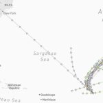
Spaghetti models for Tropical Storm Lorenzo
Special note about spaghetti models: Illustrations include an array of forecast tools and models, and not all are created equal. The hurricane center uses only the top four or five highest performing models to help make its forecasts.
➤ Track Tropical Storm Lorenzo
Is there a hurricane coming toward Florida?
No. Tropical Storm Lorenzo is expected to turn north and then east, staying well away from Florida, and is forecast to dissipate later this week, although the National Hurricane Center warned there is “low confidence” in the intensity forecast.
AccuWeather forecasters warned now is not the time to ignore the tropics. A tropical wave is expected to move off the coast of Africa and could become more organized by the end of the weekend.
“The tropical wave might be able to sneak under a lot of the hostile winds to the North, allowing for it to develop and strengthen before reaching the Lesser Antilles early next week,” said AccuWeather lede hurricane expert Alex DaSilva.
It is possible the wave could reach tropical storm status by the time it reaches the Caribbean islands.
“The fate of this tropical wave once it reaches the Caribbean Sea remains even less certain. The weather pattern late next week could pull the storm north towards the Bahamas and the United States. However, it could also continue moving west across the abnormally warm Caribbean,” according to AccuWeather.
Are there any other tropical waves, disturbances in Atlantic basin now?

The National Hurricane Center is monitoring three tropical waves:
-
A far eastern Atlantic tropical wave is along 23W, south of 13N, moving west at 11 mph. Numerous moderate to isolated strong convection is observed from 06N to 13N and between 19W and 26W.
-
Another eastern Atlantic tropical wave is along 33W, south of 12N, moving westward at 11 to 17 mph. Scattered moderate convection is occurring from 02N to 12N and between 30W and 37W.
-
A central Atlantic tropical wave is along 56W, south of 15N, moving westward at 11 to 17 mph. Scattered moderate convection is noted from 09N to 14N and between 52W and 62W.
Who is likely to be impacted by Tropical Storm Lorenzo, tropical wave?
Most current models show Lorenzo curving to the north and then east, staying well away from Florida and the U.S.
It’s too early at this time to determine if there will be any impact to Florida or the U.S. from the tropical waves.
Forecasters urge all residents to keep an eye on the tropics and to always be prepared.
Florida weather radar for Oct. 14, 2025

Weather watches and warnings issued in Florida
The Atlantic hurricane season runs from June 1 through Nov. 30.
Ninety-seven percent of tropical cyclone activity occurs during this time period, NOAA said.
The Atlantic basin includes the northern Atlantic Ocean, Caribbean Sea and Gulf of America, as the Gulf of Mexico is now known in the U.S. per an order from President Trump. NOAA and the National Hurricane Center are now using Gulf of America on its maps and in its advisories.
When is the peak of hurricane season?

Hurricane season’s ultimate peak is Sept. 10 but the season goes through Nov. 30. Credit: NOAA
The peak of the season is Sept. 10, with the most activity happening between mid-August and mid-October, according to the Hurricane Center.
Hurricane names for 2025 season
Here are the names for the 2025 Atlantic hurricane season, along with how to pronounce them. The first hurricane of the season typically forms Aug. 11.
-
Erin: (Aug. 11; hurricane Aug. 15; major hurricane Aug. 16) -
Gabrielle: (Sept. 17; hurricane Sept. 21; major hurricane Sept. 22) -
Humberto: (Sept. 24; hurricane Sept. 26; major hurricane Sept. 25) -
Imelda: (Sept. 28; hurricane Sept. 30)
National Hurricane Center map: See what forecasters watching now
Systems currently being monitored by the National Hurricane Center include:
Why does NHC say ‘tropical cyclone’ on its maps instead of hurricane or tropical storm?
Tropical cyclone is the generic term used by the National Weather Service, NOAA and the National Hurricane Center for any tropical system, even if it’s in the tropical Atlantic basin.
To be more precise, a tropical cyclone is a “rotating, organized system of clouds and thunderstorms that originates over tropical or subtropical waters and has closed, low-level circulation,” NOAA sadi.
Once maximum sustained winds reach 74 mph, what it is called is determined by where it originated:
-
Hurricane: for storms in the North Atlantic, central North Pacific, and eastern North Pacific.
-
Typhoon: for storms in the Northwest Pacific.
-
Cyclone: for storms in the South Pacific and Indian Ocean.
Interactive map: Hurricanes, tropical storms that have passed near your city
Stay informed. Get weather alerts via text
What’s next?
We will update our tropical weather coverage daily.
Download your local site’s app to ensure you’re always connected to the news. And look for our special subscription offers here.
This article originally appeared on The Daytona Beach News-Journal: Hurricane Center tracks Tropical Storm Lorenzo path. Florida impacts?