The National Hurricane Center is watching Tropical Storm Gabrielle, which is only hours from becoming a hurricane. Behind Gabrielle is another system, and forecasters say conditions in front of that group of storms are favorable for development later this week.
Tropical Storm Gabrielle formed in the central Atlantic Sept. 17, becoming the first named storm since Fernand in late August. It would be the second hurricane of the 2025 Atlantic hurricane season.
➤ Track all active storms, Tropical Storm Gabrielle
➤ Weather alerts via text: Sign up to get updates about current storms and weather events by location
Gabrielle is expected to become a hurricane Sunday, Sept. 21 and pass east of Bermuda, more than 1,000 miles from Florida. The other hurricane this season so far was last month’s Erin.
The National Hurricane Center is monitoring three tropical waves — including one in the Caribbean — and a tropical disturbance in the Atlantic with a low chance for development over the next seven days.
The next named storm of the season will be Humberto.
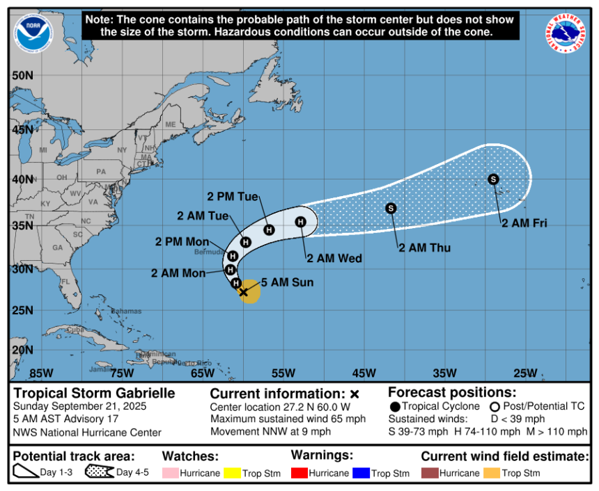
Here’s the latest advisory from the National Hurricane Center as of 8 a.m., Sept. 21:
Will Tropical Storm Gabrielle become a hurricane?
The National Hurricane Center said Tropical Storm Gabrielle is expected to become a hurricane Sunday, Sept. 21.
Current forecasts call for Gabrielle to strengthen into a Category 2 storm, with maximum sustained winds of 100 mph, within the next 12 hours.
Special note about spaghetti models: Illustrations include an array of forecast tools and models, and not all are created equal. The hurricane center uses only the top four or five highest performing models to help make its forecasts.
➤ Track Tropical Storm Gabrielle
What other tropical waves, disturbances are in Atlantic basin now?

Tropical wave in central tropical Atlantic: A broad tropical wave moving into the central tropical Atlantic continues to produce disorganized showers and thunderstorms well to the west-southwest of the Cabo Verde Islands. Although environmental conditions are not favorable for initial development of this system over the next day or two, these conditions should gradually become more favorable for development by the middle to latter part of this week, and a tropical depression could form while the system moves west-northwestward to northwestward across the central Atlantic.
-
Formation chance through 48 hours: low, near 0 percent.
-
Formation chance through 7 days: low, 40 percent.
Tropical waves being monitored by National Hurricane Center:
-
An eastern Atlantic tropical wave has its axis near 32W, south of 21N, moving westward at 11 mph. A 1011 mb low is along the wave axis near 13N33W. Scattered moderate convection is noted from S of 15N between 30W-36W.
-
A central Atlantic tropical wave has its axis near 47W, south of 21N, moving westward at 11 mph. Scattered moderate convection is over the northern half of the wave.
-
A western Caribbean tropical wave is along 81W, from 21N southward from the Cayman Islands to Panama. Scattered showers are noted along the wave axis.
What do the colored, hatched areas on the NOAA map mean?
The hatched areas on the National Hurricane Center’s tropical outlook map indicate “areas where a tropical cyclone — which could be a tropical depression, tropical storm or hurricane — could develop,” said National Hurricane Center Deputy Director Jamie Rhome.
The colors make it visibly clear how likely a system could develop, with yellow being low, orange medium, and red high.
The National Hurricane Center generally doesn’t issue tropical advisories until there is a named storm, but there is an exception.
“If a system is near land and there is potential for development, the National Hurricane Center won’t wait before it issues advisories, even if the system hasn’t become an actual storm. This gives residents time to prepare,” Rhome said.
Are any hurricanes coming to Florida?
Not at this time. Current models predict Tropical Storm Gabrielle will stay well east of Florida and the United States.
Residents in Bermuda were advised to closely monitor the storm, which is expected become a hurricane Sunday as it passes near the island.
It’s too early to tell where the other tropical waves out there will go or who they will impact.
How could Tropical Storm Gabrielle affect Florida?
While current predictions are for Gabrielle to stay well away from Florida and the U.S. East Coast, it is possible there could be some indirect impacts from the tropical storm or hurricane.
“A weakness in the Bermuda high and steering winds will help turn Gabrielle to the north and keep the storm well away from the United States East Coast,” AccuWeather Lead Hurricane Expert Alex DaSilva said.
➤ Tropical Storm Gabrielle expected to strengthen into hurricane. What can Florida expect?
“That’s something we’re going to have to watch for. If the storm stays relatively weak, if it never gets to a hurricane, then we probably won’t have any beach hazards, but if it really intensifies north of the Caribbean and becomes a hurricane, we do have to be concerned for some rip current risks along the east coast next week.
“It could be a beautiful sunny day at the beach, but even if there’s a hurricane hundreds and hundreds of miles away, we can still see issues from rip currents,” DaSilva said.
Colorado State University predicting tropical activity will pick up
In its latest two-week forecast for Sept. 17-30, Colorado State University forecasters predicted activity will pick up over the next couple of weeks.
“Global model ensembles are hinting at potential additional tropical cyclone development in one to two weeks in both the eastern/central Atlantic as well as the Gulf/western Caribbean.
“The primary threat formation area for major hurricanes in mid- to late September is in the eastern and central tropical Atlantic.”
Watch Gulf or western Caribbean for storms

Conditions expected in tropical Atlantic late September 2025.
“I’m still concerned about the Gulf,” DaSilva said.
“Those waters are still exceptionally warm, so I’m concerned that something might try to develop in the Western Caribbean or in the Gulf late this month. Those waters in the Caribbean and in the Gulf are very untouched. Really, nothing has gone through there. Hurricane season goes through the end of November, so there’s going to be plenty of chances, I think, to see development in these areas, and that’s why we don’t want people to tune out.”
Tropical development typically requires ocean temperatures of at least 80 degrees, according to AccuWeather. Portions of the Gulf and Caribbean are experiencing water temperatures well into the 80s to near 90.
“When tropical storms and hurricanes form in the western Caribbean or Gulf, there is much less preparation time compared to a similar system that forms over the Atlantic and heads toward Central America or the U.S.,” AccuWeather said.
Forecasters urge all residents to keep an eye on the tropics and to always be prepared.
Officials regularly encourage Florida residents to prepare for storms before a hurricane is approaching, while shelves are fully stocked and you aren’t battling crowds all rushing to the store at the same time.
“It only takes one storm to make it an impactful year for your community,” the National Hurricane Center Miami posted on X.
➤ See list of emergency supplies you can now buy tax free
On Aug. 1, specific hurricane supplies became permanently tax-free in Florida, ranging from batteries to generators.
➤ Don’t have a hurricane supply kit? From the basics to the extras, here’s what you need
Here are some of the basics you should have:
-
Two-week supply of medications
-
A go-bag with essential supplies in case you need to leave quickly
-
Portable cellphone chargers
-
List of emergency phone numbers, including those for family members
-
Copy of your insurance policy
Florida weather radar for Sept. 21, 2025

Weather watches and warnings issued in Florida
When does hurricane season end?
The Atlantic hurricane season runs from June 1 through Nov. 30.
Ninety-seven percent of tropical cyclone activity occurs during this time period, NOAA said.
The Atlantic basin includes the northern Atlantic Ocean, Caribbean Sea and Gulf of America, as the Gulf of Mexico is now known in the U.S. per an order from President Trump. NOAA and the National Hurricane Center are now using Gulf of America on its maps and in its advisories.
When is the peak of hurricane season?

Hurricane season’s ultimate peak is Sept. 10 but the season goes through Nov. 30. Credit: NOAA
The peak of the season is Sept. 10, with the most activity happening between mid-August and mid-October, according to the Hurricane Center.
Hurricane names for 2025 season
Here are the names for the 2025 Atlantic hurricane season, along with how to pronounce them. The first hurricane of the season typically forms Aug. 11.
-
Erin: (Aug. 11; hurricane Aug. 15; major hurricane Aug. 16) -
Gabrielle: ga-bree-ELL (Sept. 17)
National Hurricane Center map: See what forecasters watching now
Systems currently being monitored by the National Hurricane Center include:
Interactive map: Hurricanes, tropical storms that have passed near your city
Stay informed. Get weather alerts via text
What’s next?
We will update our tropical weather coverage daily.
Download your local site’s app to ensure you’re always connected to the news. And look for our special subscription offers here.
(This story has been updated to include new information.)
This article originally appeared on The Daytona Beach News-Journal: Gabrielle’s hurricane chances increase as tropical wave tracked