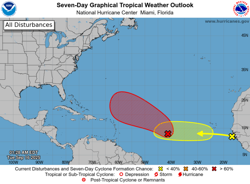
Chances have increased for development of a tropical depression or tropical storm to form in the central Atlantic.
And another tropical wave with a low chance for development is moving off the coast of Africa, according to the latest advisory from the National Hurricane Center.
A tropical depression or tropical storm is likely to form in the central Atlantic in the next day or two, the National Hurricane Center said.
If maximum sustained winds reach at least 39 mph, it would become Tropical Storm Gabrielle, the seventh named storm of the 2025 Atlantic hurricane season.
Here’s the latest advisory from the National Hurricane Center as of 8 a.m., Sept. 16:
➤ Track all active storms, Invest 92L
➤ Weather alerts via text: Sign up to get updates about current storms and weather events by location
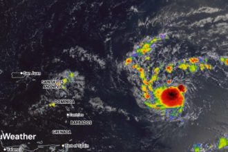
Are there any storms in the Atlantic right now? Invest 92L ‘very likely to organize into Tropical Storm Gabrielle’
As of Tuesday morning, Sept. 16, there are no named storms in the Atlantic. However, the National Hurricane Center is monitoring one disturbance.
Invest 92L
-
Location: Central tropical Atlantic
-
Movement: West to west-northwest at 10 to 15 mph
-
Formation chance in 48 hours: Medium, 60%
-
Formation chance in 7 days: High, 90%
The National Hurricane Center gives Invest 92L a very high chance of developing into a tropical depression or tropical storm in the next day or two as it moves into an area favorable for development.
“This disturbance is very likely to organize into Tropical Storm Gabrielle sometime during the middle or latter part of this work week, and it will likely continue to intensify into a hurricane,” according to Fox Weather meteorologist Ian Oliver via email Sept. 15.
“Forecast models are pretty convinced that this storm will make a turn to the north long before the Caribbean Islands, but some impacts can’t be totally ruled out at this point. Forecasts for storms that haven’t developed yet (like this one) are subject to a little more uncertainty so it’s smart to watch. Otherwise, folks in Bermuda most certainly need to keep an eye on this over the next week,” Oliver said.
Spaghetti models for Invest 92L. See expected path
Special note about spaghetti models: Spaghetti model illustrations include an array of forecast tools and models, and not all are created equal. The Hurricane Center uses only the top four or five highest performing models to help make its forecasts.
What tropical waves, disturbances are in Atlantic basin now?
Other tropical waves being monitored by National Hurricane Center:
-
The axis of an eastern Caribbean tropical wave is near 68W south of 20N. It is moving westward at around 17 mph. Scattered moderate convection is noted from 15N to 17N between 65W and 68W.
-
The axis of a central Atlantic tropical wave is near 48W from 01N to 20N. It is moving westward at around 11 to 17 mph. Scattered moderate and isolated strong convection is noted from 14N to 20N between 45W and 50W.
Track all storms in the Atlantic
Hurricane season set to ramp up by late September
While the basin has been quiet — even through the climatological peak on Sept. 10 — officials warn that activity is likely to increase as suppressing factors like dry air and wind shear begin to fade.
Of particular concern are storms that form close to the United States. Unlike tropical waves that roll off Africa and give forecasters days to track, systems that develop in the Gulf, Caribbean or off the Southeast coast can catch residents with little time to prepare.
These “homegrown” storms can also rapidly intensify in the Gulf’s extremely warm waters, AccuWeather forecasters said.
Are any hurricanes coming to Texas?
No. While a couple disturbances have emerged in Atlantic, none are officially named storms yet.
It’s also too early at this time to determine if there will be any impact to Texas or the U.S. from the other tropical waves out there.
Conditions can change rapidly, though, and forecasters warn residents to not become complacent and to always be prepared.
How does the 2025 Atlantic hurricane season compare to last year in Texas?
For Texas, the season has been relatively quiet so far — a sharp contrast to mid-August last year, when the state was already six weeks past the final storm to impact the state, which saw the two earliest storms of the 2024 hurricane season.
In late June 2024, Tropical Storm Alberto threatened Texas, and by early July, the Lone Star State was tracking one one of the hardest-hit hurricanes of the season — Hurricane Beryl, which became the earliest Category 5 storm on record before making its third landfall near Matagorda. After that, the remainder of the season was relatively mild for Texas, with no other storm threatening the state.
No storms have directly affected Texas this season, but forecasters warn the season is ramping up.
What are the chances of Texas getting hit by hurricane in 2025?
CSU calculated the probability of a named storm, hurricane and major hurricane tracking within 50 miles for each state from Texas to Maine. Here are the probabilities of the following tracking within 50 miles of Texas:
When does the Atlantic hurricane season end in Texas?
The Atlantic hurricane season runs from June 1 through Nov. 30.
Ninety-seven percent of tropical cyclone activity occurs during this time period, NOAA said.
The Atlantic basin includes the northern Atlantic Ocean, Caribbean Sea and Gulf of America, as the Gulf of Mexico is now known in the U.S. per an order from President Trump. The National Oceanic and Atmospheric Administration and the National Hurricane Center are now using Gulf of America on their maps and in advisories.
The peak of the season is Sept. 10, with the most activity happening between mid-August and mid-October, according to the Hurricane Center.
Prepare now for hurricanes
Delaying potentially life-saving preparations could mean waiting until it’s too late. “Get your disaster supplies while the shelves are still stocked, and get that insurance checkup early, as flood insurance requires a 30-day waiting period,” NOAA recommends.
-
Develop an evacuation plan: If you are at risk from hurricanes, you need an evacuation plan. Now is the time to begin planning where you would go and how you would get there.
-
Assemble disaster supplies: Whether you’re evacuating or sheltering in place, you’re going to need supplies not just to get through the storm but for the potentially lengthy aftermath, NOAA said.
-
Get an insurance checkup and document your possessions: Contact your insurance company or agent now and ask for an insurance checkup to make sure you have enough insurance to repair or even replace your home and/or belongings. Remember, home and renters insurance doesn’t cover flooding, so you’ll need a separate policy for it. Flood insurance is available through your company, agent or the National Flood Insurance Program. Act now, as flood insurance requires a 30-day waiting period.
-
Create a family communication plan: NOAA recommends taking the time now to write down your hurricane plan and share it with your family. Determine family meeting places, and make sure to include an out-of-town location in case of evacuation.
-
Strengthen your home: Now is the time to improve your home’s ability to withstand hurricane impacts. Trim trees; install storm shutters, accordion shutters, and/or impact glass; seal outside wall openings.
Texas weather radar

Texas weather watches and warnings
Interactive map: Hurricanes, tropical storms that have passed near your city
Stay informed. Get weather alerts via text
Brandi D. Addison covers weather across the United States as the Weather Connect reporter for the USA TODAY Network. She can be reached at baddison@gannett.com.
This article originally appeared on Corpus Christi Caller Times: Tropical Storm Gabrielle ‘very likely to organize’. Spaghetti models