A day after the climatological peak of hurricane season — marking only the ninth time in 75 years, and the first in nearly a decade, without a named storm — a new tropical disturbance has popped up in the eastern Atlantic.
Experts caution that the lull may not last after what’s started as a seemingly quiet hurricane season.
Last year, the Atlantic saw similar lulls in July and August, followed by a surge of storms in September. Several storms struck the U.S., including Hurricane Helene — first highlighted by the National Hurricane Center on Sept. 17 — and Hurricane Milton, both in late September and early October.
This year, the basin has been unusually quiet through the climatological peak. Factors such as dry air and wind shear have suppressed storm formation, but forecasts suggest these conditions may ease in the coming weeks.
If the Madden–Julian Oscillation strengthens and moves into the Western Hemisphere by next week — as predicted by Colorado State University researchers — conditions could start to take shape and begin to resemble those that helped Helene form last year, particularly in the western Caribbean.
So far, this season has produced six named storms, none of which have made U.S. landfall, though Erin brought some serious impacts to North Carolina’s Outer Banks. The next named storm is Gabrielle.
➤ Weather alerts via text: Sign up to get updates about current storms and weather events by location
Are there any storms in the Atlantic right now?
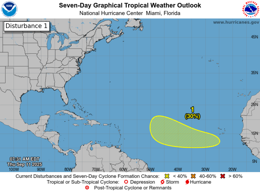
As of Thursday morning, Sept. 11, there are no named storms in the Atlantic. However, the National Hurricane Center is monitoring one disturbance.
Disturbance 1:
-
Location: Eastern and central tropical Atlantic
-
Movement: West to west-northwest at ~15 mph
-
Formation chance in 48 hours: Near 0%
-
Formation chance in 7 days: 30%
A tropical disturbance has a 30% chance of development over the next seven days, as of Thursday, Sept. 11, 2025.
The system is expected to emerge off the coast of West Africa by Friday. Forecasters say conditions could allow for gradual development over the weekend into early next week.
While the basin has been quiet — even through the climatological peak of the season — officials caution that activity is likely to increase as suppressing factors like dry air and wind shear begin to dissipate.
Of special concern are storms that develop close to the United States. Instead of being able to watch tropical waves move off the coast of Africa and make their way across the entire Atlantic, systems that form in the Gulf, Caribbean or off the Southeast coast give residents much less time to react.
Those storms, also known as “homegrown,” can rapidly intensify, especially in the extremely warm waters of the Gulf, AccuWeather forecasters warned.
What tropical waves, disturbances are in the Atlantic basin now?
-
An eastern Atlantic tropical wave is near 35W from 18N southward. It is moving west at around 10 mph. Scattered moderate convection is found from 14N to 17N between 25W and 36W.
-
A central Atlantic tropical wave is near 56W from 17N southward, moving toward the west around 10 mph. Scattered moderate convection is found from 11N to 15N and between 53W and 58W.
What is the Madden–Julian Oscillation?
The Madden–Julian Oscillation (MJO) is a large-scale pattern of tropical atmospheric circulation that moves eastward around the globe roughly every 30–60 days. It’s best known for alternating enhanced (wet) and suppressed (dry) phases of rainfall in the tropics.
-
Enhanced phase: More clouds, thunderstorms and upward motion.
-
Suppressed phase: Less convection, drier air and downward motion.
The MJO is a key driver of variability in the tropics. During its active phase over the Atlantic or Caribbean, rising air and increased thunderstorms help disturbances organize, while added moisture fuels the convective activity critical for tropical cyclones.
Global model forecasts suggest that areas influenced by the MJO over the coming two weeks could generate moderate to high levels of accumulated cyclone energy (ACE) — meaning the overall number, strength and lifespan of storms in the Atlantic is likely to increase by late September, according to Colorado State University researchers.
Models are also signaling potential tropical cyclone development in the eastern Atlantic and the western Caribbean/southern Gulf.
Overall, environmental conditions are expected to become more favorable for storm formation, with reduced vertical wind shear coinciding with the MJO’s movement across the Western Hemisphere and potentially over Africa. “Historically, MJO events over Africa are associated with above-average Atlantic hurricane activity,” the latest forecast from Colorado State University says.
Are any hurricanes coming to Texas?
No. A new tropical disturbance has emerged, but it still is at low chance for development — at 30% over the next seven days.
It’s also too early at this time to determine if there will be any impact to Texas or the U.S. from the other tropical waves out there.
Conditions can change rapidly, though, and forecasters warn residents to not become complacent and to always be prepared.
‘Where the heck are the Atlantic hurricanes?’
Ahead of the climatological peak on Tuesday, Sept. 9, Philip Klotzbach, meteorologist with Colorado State University, took to X to comment on how unusual the lack of storms are this year during the peak of the Atlantic hurricane season.
“Where the heck are the Atlantic #hurricanes? While we don’t claim to know exactly why it’s gotten so quiet, we have written a discussion on the season to date, some drivers of the lull as well as some thoughts on the remainder of the season.”
Reasons cited for the “extremely quiet” season so far included:
-
A dry and stable tropical Atlantic
-
Conditions in Africa suppress the formation of easterly waves
“No tropical storms or hurricanes over the Atlantic basin on Sept. 10 has only happened three times over the last 30 years,” DaSilva said.
“Since 1950, there have only been eight total years without a tropical storm or greater over the Atlantic for the peak date.”
How does the 2025 Atlantic hurricane season compare to last year in Texas?
For Texas, the season has been relatively quiet so far — a sharp contrast to mid-August last year, when the state was already six weeks past the final storm to impact the state, which saw the two earliest storms of the 2024 hurricane season.
In late June 2024, Tropical Storm Alberto threatened Texas, and by early July, the Lone Star State was tracking one one of the hardest-hit hurricanes of the season — Hurricane Beryl, which became the earliest Category 5 storm on record before making its third landfall near Matagorda. After that, the remainder of the season was relatively mild for Texas, with no other storm threatening the state.
No storms have directly affected Texas this season, but forecasters warn the season is ramping up.
What are the chances of Texas getting hit by hurricane in 2025?
CSU calculated the probability of a named storm, hurricane and major hurricane tracking within 50 miles for each state from Texas to Maine. Here are the probabilities of the following tracking within 50 miles of Texas:
When does the Atlantic hurricane season end in Texas?
The Atlantic hurricane season runs from June 1 through Nov. 30.
Ninety-seven percent of tropical cyclone activity occurs during this time period, NOAA said.
The Atlantic basin includes the northern Atlantic Ocean, Caribbean Sea and Gulf of America, as the Gulf of Mexico is now known in the U.S. per an order from President Trump. The National Oceanic and Atmospheric Administration and the National Hurricane Center are now using Gulf of America on their maps and in advisories.
The peak of the season is Sept. 10, with the most activity happening between mid-August and mid-October, according to the Hurricane Center.
Prepare now for hurricanes
Delaying potentially life-saving preparations could mean waiting until it’s too late. “Get your disaster supplies while the shelves are still stocked, and get that insurance checkup early, as flood insurance requires a 30-day waiting period,” NOAA recommends.
-
Develop an evacuation plan: If you are at risk from hurricanes, you need an evacuation plan. Now is the time to begin planning where you would go and how you would get there.
-
Assemble disaster supplies: Whether you’re evacuating or sheltering in place, you’re going to need supplies not just to get through the storm but for the potentially lengthy aftermath, NOAA said.
-
Get an insurance checkup and document your possessions: Contact your insurance company or agent now and ask for an insurance checkup to make sure you have enough insurance to repair or even replace your home and/or belongings. Remember, home and renters insurance doesn’t cover flooding, so you’ll need a separate policy for it. Flood insurance is available through your company, agent or the National Flood Insurance Program. Act now, as flood insurance requires a 30-day waiting period.
-
Create a family communication plan: NOAA recommends taking the time now to write down your hurricane plan and share it with your family. Determine family meeting places, and make sure to include an out-of-town location in case of evacuation.
-
Strengthen your home: Now is the time to improve your home’s ability to withstand hurricane impacts. Trim trees; install storm shutters, accordion shutters, and/or impact glass; seal outside wall openings.
Texas weather radar

Texas weather watches and warnings
Interactive map: Hurricanes, tropical storms that have passed near your city
Stay informed. Get weather alerts via text
Brandi D. Addison covers weather across the United States as the Weather Connect reporter for the USA TODAY Network. She can be reached at baddison@gannett.com.
This article originally appeared on Corpus Christi Caller Times: Hurricane Center tracks new tropical system. What to know in Texas