The National Hurricane Center is monitoring a tropical wave off the coast of Africa that shows an increased chance for development over the next seven days.
A tropical depression could form by the middle part of next week as it moves west or west-northwest across the Atlantic, forecasters said.
The potential storm comes just after the peak of hurricane season arrived Sept. 10.
➤ Weather alerts via text: Sign up to get updates about current storms and weather events by location
It was the “first climatological peak of the Atlantic hurricane season in nearly a decade without a named storm in the basin,” AccuWeather Lead Hurricane Expert Alex DaSilva said.
“No tropical storms or hurricanes over the Atlantic basin on Sept. 10 has only happened three times over the last 30 years,” DaSilva said.
The National Hurricane Center currently is tracking three other tropical waves in the Atlantic basin, which covers the northern Atlantic, Gulf and Caribbean, along with the one expected to move off Africa.
So far, this season has produced six named storms, none of which have made U.S. landfall, though Erin brought some serious impacts to North Carolina’s Outer Banks. The next named storm is Gabrielle.
Are there any storms in the Atlantic right now?
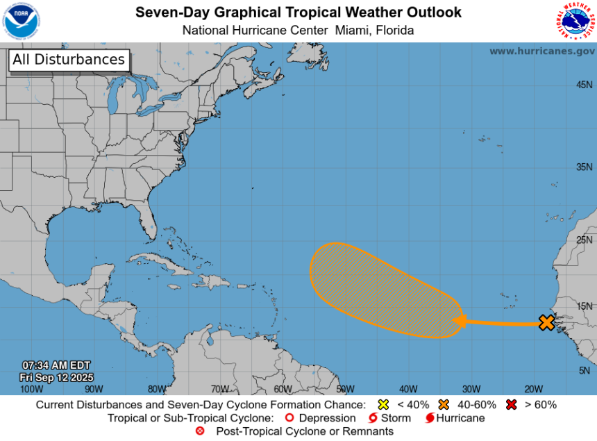
As of Friday morning, Sept. 12, there are no named storms in the Atlantic. However, the National Hurricane Center is monitoring one disturbance.
Disturbance 1:
-
Location: Eastern and central tropical Atlantic
-
Movement: West to west-northwest at 10 to 15 mph
-
Formation chance in 48 hours: Near 0%
-
Formation chance in 7 days: 40%
Tropical conditions 8 a.m. Sept. 12, 2025.
The tropical wave located near the west coast of Africa is producing disorganized showers and thunderstorms over the far eastern Atlantic.
Environmental conditions appear conducive for some gradual development of this system over the next several days.
A tropical depression could form by the middle part of next week while it moves westward to west-northwestward at 10 to 15 mph over the eastern and central tropical Atlantic, according to the National Hurricane Center.
Hurricane season set to ramp up by late September
While the basin has been quiet — even through the climatological peak — officials warn that activity is likely to increase as suppressing factors like dry air and wind shear begin to fade.
Of particular concern are storms that form close to the United States. Unlike tropical waves that roll off Africa and give forecasters days to track, systems that develop in the Gulf, Caribbean or off the Southeast coast can catch residents with little time to prepare.
These “homegrown” storms can also rapidly intensify in the Gulf’s extremely warm waters, AccuWeather forecasters said.
Colorado State University researchers note that if the Madden–Julian Oscillation strengthens and shifts into the Western Hemisphere next week as expected, conditions are more conducive to tropical cyclone formation.
What is the Madden–Julian Oscillation?
The Madden–Julian Oscillation (MJO) is a large-scale pattern of tropical atmospheric circulation that moves eastward around the globe roughly every 30–60 days. It’s best known for alternating enhanced (wet) and suppressed (dry) phases of rainfall in the tropics.
-
Enhanced phase: More clouds, thunderstorms and upward motion.
-
Suppressed phase: Less convection, drier air and downward motion.
The MJO is a key driver of variability in the tropics. During its active phase over the Atlantic or Caribbean, rising air and increased thunderstorms help disturbances organize, while added moisture fuels the convective activity critical for tropical cyclones.
Global model forecasts suggest that areas influenced by the MJO over the coming two weeks could generate moderate to high levels of accumulated cyclone energy (ACE) — meaning the overall number, strength and lifespan of storms in the Atlantic is likely to increase by late September, according to Colorado State University researchers.
Models are also signaling potential tropical cyclone development in the eastern Atlantic and the western Caribbean/southern Gulf.
Overall, environmental conditions are expected to become more favorable for storm formation, with reduced vertical wind shear coinciding with the MJO’s movement across the Western Hemisphere and potentially over Africa. “Historically, MJO events over Africa are associated with above-average Atlantic hurricane activity,” the latest forecast from Colorado State University says.
Are any hurricanes coming to South Carolina?
No. A new tropical disturbance has emerged, but it still is at medium chance for development — at 40% over the next seven days.
It’s also too early at this time to determine if there will be any impact to South Carolina or the U.S. from the other tropical waves out there.
Conditions can change rapidly, though, and forecasters warn residents to not become complacent and to always be prepared.
When does the Atlantic hurricane season end in South Carolina?
The Atlantic hurricane season runs from June 1 through Nov. 30.
Ninety-seven percent of tropical cyclone activity occurs during this time period, NOAA said.
The Atlantic basin includes the northern Atlantic Ocean, Caribbean Sea and Gulf of America, as the Gulf of Mexico is now known in the U.S. per an order from President Donald Trump. NOAA and the National Hurricane Center are now using Gulf of America on its maps and in its advisories.
The peak of the season is Sept. 10, with the most activity happening between mid-August and mid-October, according to the Hurricane Center.
Prepare now for hurricanes
Delaying potentially life-saving preparations could mean waiting until it’s too late. “Get your disaster supplies while the shelves are still stocked, and get that insurance checkup early, as flood insurance requires a 30-day waiting period,” NOAA recommends.
-
Develop an evacuation plan: If you are at risk from hurricanes, you need an evacuation plan. Now is the time to begin planning where you would go and how you would get there.
-
Assemble disaster supplies: Whether you’re evacuating or sheltering-in-place, you’re going to need supplies not just to get through the storm but for the potentially lengthy aftermath, NOAA said.
-
Get an insurance checkup and document your possessions: Contact your insurance company or agent now and ask for an insurance check-up to make sure you have enough insurance to repair or even replace your home and/or belongings. Remember, home and renters insurance doesn’t cover flooding, so you’ll need a separate policy for it. Flood insurance is available through your company, agent, or the National Flood Insurance Program. Act now, as flood insurance requires a 30-day waiting period.
-
Create a family communication plan: NOAA says to take the time now to write down your hurricane plan and share it with your family. Determine family meeting places, and make sure to include an out-of-town location in case of evacuation.
-
Strengthen your home: Now is the time to improve your home’s ability to withstand hurricane impacts. Trim trees; install storm shutters, accordion shutters, and/or impact glass; seal outside wall openings.
South Carolina weather radar

South Carolina weather watches and warnings
Interactive map: Hurricanes, tropical storms that have passed near your city
Stay informed. Get weather alerts via text
Brandi D. Addison covers weather across the United States as the Weather Connect Reporter for the USA TODAY Network. She can be reached at baddison@gannett.com.
This article originally appeared on Greenville News: South Carolina hurricane season, tropical wave pops up in Atlantic