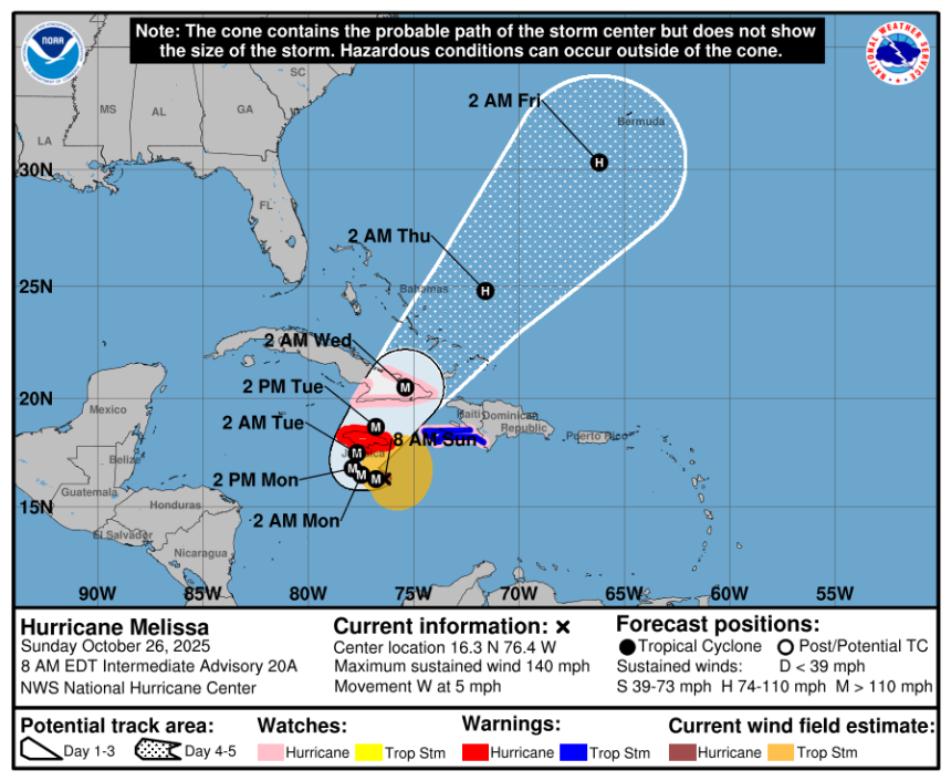
Hurricane Melissa is expected to become a Category 5 storm by Sunday night, Oct. 26, and forecast to have devastating impacts on islands in the northern Caribbean, according to the National Hurricane Center in Florida.
Melissa is expected to move near or over Jamaica through Tuesday, across southeastern Cuba Tuesday night, and across the southeastern Bahamas on Wednesday.
Catastrophic and life-threatening flash flooding and landslides are expected in portions of Jamaica, southern Haiti and the Dominican Republic through the weekend, the NHC said.
➤ Weather alerts via text: Sign up to get updates about current storms and weather events by location
According to the hurricane center, Hurricane Melissa has a significant possibility of making landfall on Jamaica as a major hurricane and could maintain major hurricane strength when it reaches eastern Cuba.
Significant impacts to Florida and the U.S. East Coast are not expected at this time.
➤ WeatherTiger: Melissa a monster in the making with Florida dodging the bullet
Hurricane Melissa latest satellite images, weather graphics
Spaghetti models for Hurricane Melissa. See trajectory, path
Special note about spaghetti models: Spaghetti model illustrations include an array of forecast tools and models, and not all are created equal. The Hurricane Center uses only the top four or five highest performing models to help make its forecasts.
Where is Hurricane Melissa now? Where is it headed?
Special note on the NHC cone: The forecast track shows the most likely path of the center of the storm. It does not illustrate the full width of the storm or its impacts, and the center of the storm is likely to travel outside the cone up to 33% of the time.
Is a hurricane coming to Florida?
Melissa poses “little to no risk to Florida or the continental U.S.,” said Dr. Ryan Truchelut, chief meteorologist at WeatherTiger, who works with the USA TODAY Network.
“Odds of any outer bands of Melissa even minimally scraping southeast Florida on its way out (into the Atlantic) are around 5%.”
“The timing and strength of a dip in the jet stream over the eastern United States next week will help determine the path that Melissa takes through the northern Caribbean and into the southwestern Atlantic,” AccuWeather Lead Hurricane Expert Alex DaSilva said Oct. 25. “At this time, the odds of ‘direct’ rain and wind impacts from Melissa reaching the U.S. East Coast are low.
Forecasters caution residents to monitor the tropics and stay prepared.
Track Hurricane Melissa, all active Atlantic storms and disturbances
Can’t see the graphic? Open in a new browser.
NWS weather radar shows storms affecting Florida

Latest weather watches and warnings issued in Florida
No watches or warnings associated with Hurricane Melissa are in effect for Florida or the U.S. as of Oct. 25.
Excessive rainfall forecast across Florida
Stay informed. Get weather alerts via text
What’s next?
We will update our tropical weather coverage daily.
Download your local site’s app to ensure you’re always connected to the news. And look for our special subscription offers here.
This article originally appeared on Naples Daily News: Hurricane Melissa trajectory, track, spaghetti models. Florida update