Tropical Storm Imelda continues to strengthen and is expected to become a hurricane later today, Tuesday, Sept. 30.
The storm is expected to grow stronger as it approaches Bermuda late Wednesday, Oct. 1.
Swells and high surf from both Tropical Storm Imelda and Hurricane Humberto are expected to bring dangerous marine conditions and rip currents along much of Florida and the East Coast of the United States during the next several days.
➤ Weather alerts via text: Sign up to get updates about current storms and weather events by location
Gusty winds and rain bands moving onshore are also possible along east central Florida, according to the National Weather Service.
Latest weather watches and warnings issued in Florida
No tropical storm or hurricane watches or warnings are in effect on land for Florida or the U.S.
A hurricane watch is in effect for Bermuda.
Storm tracker: Where is Tropical Storm Imelda going?
Special note on the NHC cone: The forecast track shows the most likely path of the center of the storm. It does not illustrate the full width of the storm or its impacts, and the center of the storm is likely to travel outside the cone up to 33% of the time.
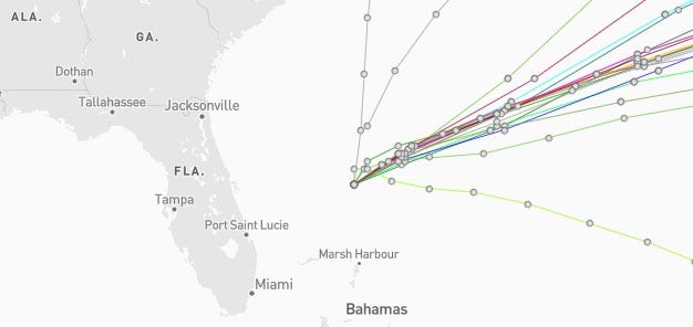
Tropical Storm Imelda spaghetti models, path
Special note about spaghetti models: Illustrations include an array of forecast tools and models, and not all are created equal. The hurricane center uses only the top four or five highest performing models to help make its forecasts.
What impacts can Florida expect from Tropical Storm Imelda?
Swells and high surf from both Humberto and Imelda are expected to produce dangerous marine conditions and rip currents along much of the East Coast of the United States during the next several days.
Breaking waves of 6 to 10 feet are possible, along with seas of 9 to 18 feet, according to the National Weather Service Melbourne.
Outer rain bands associated with Imelda could move onshore Tuesday, and breezy conditions — with gusts up to 25 mph — at the coast are possible along east central Florida, according to the National Weather Service
Florida weather radar for Tuesday, Sept. 30, 2025, with Tropical Storm Imelda offshore

Excessive rainfall forecast across Florida
What storms are in the tropics right now?

This auto-updated graphic shows a map of all active storms in the Atlantic basin.
Can’t see the graphic? Open in a new browser.
Forecasters urge all residents to keep an eye on the tropics and to always be prepared
Officials regularly encourage Florida residents to prepare for storms before a hurricane is approaching, while shelves are fully stocked and you aren’t battling crowds all rushing to the store at the same time.
“It only takes one storm to make it an impactful year for your community,” the National Hurricane Center Miami posted on X.
➤ See list of emergency supplies you can now buy tax free
On Aug. 1, specific hurricane supplies became permanently tax-free in Florida, ranging from batteries to generators.
➤ Don’t have a hurricane supply kit? From the basics to the extras, here’s what you need
Here are some of the basics you should have:
-
Two-week supply of medications
-
A go-bag with essential supplies in case you need to leave quickly
-
Portable cellphone chargers
-
List of emergency phone numbers, including those for family members
-
Copy of your insurance policy
When does hurricane season end?
The Atlantic hurricane season runs from June 1 through Nov. 30.
Ninety-seven percent of tropical cyclone activity occurs during this time period, NOAA said.
The Atlantic basin includes the northern Atlantic Ocean, Caribbean Sea and the newly renamed Gulf of America, formerly the Gulf of Mexico.
Stay informed. Get weather alerts via text
What’s next?
We will update our tropical weather coverage daily.
Download your local site’s app to ensure you’re always connected to the news. And look for our special subscription offers here.
This article originally appeared on Palm Beach Post: Tropical Storm Imelda spaghetti models, path, location, storm tracker