Tropical Storm Imelda was moving north off the coast of Florida Monday, Sept. 29, according to the National Hurricane Center.
The tropical storm is expected to move across the northwestern Bahamas today.
It’s then expected to turn away from Florida and the southeastern United States toward the middle of the week as it is pulled by Hurricane Humberto to its east and pushed by a system of high pressure building over the northeastern U.S.
➤ Weather alerts via text: Sign up to get updates about current storms and weather events by location
The National Hurricane Center warned Imelda could become a hurricane Tuesday, Sept. 30.
A tropical storm watch on Florida’s east coast over the weekend is no longer in effect as Imelda’s path shifted farther east.
However, there could be significant beach impacts in Florida starting today, including life-threatening rip currents, high surf and dune erosion, according to the National Weather Service, Melbourne.
Latest weather watches and warnings issued in Florida
No tropical storm or hurricane watches are in effect on land for Florida or the U.S.
Storm tracker: Where is Tropical Storm Imelda going?
Special note on the NHC cone: The forecast track shows the most likely path of the center of the storm. It does not illustrate the full width of the storm or its impacts, and the center of the storm is likely to travel outside the cone up to 33% of the time.
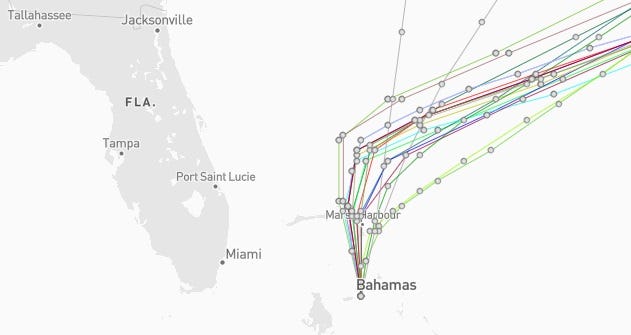
Tropical Storm Imelda spaghetti models, path
What impacts can Florida expect from Tropical Storm Imelda?

Conditions possible from Tropical Storm Imelda Sept. 29, 2025.
Storm total rainfall amounts of 1 to 2 inches are expected through Tuesday across northeast Florida, according to the National Hurricane Center. Some areas could see up to 4 inches.
Storm surge from the Volusia/Brevard County line in Florida to the South Santee River in South Carolina could be 1 to 2 feet.
Swells generated by Imelda are likely to cause life-threatening surf and rip current conditions.
The National Weather Service said coastal residents can expect:
-
A high risk for life-threatening rip currents.
-
Surf heights of 6 to 10 feet north of Cape Canaveral and 4 to 8 feet south.
-
Nearshore seas of 10 to 13 feet north of Cape Canaveral and 8 to 11 feet south of the Cape. Seas could be 11 to 18 feet offshore.
-
High risk for rip currents
-
Scattered showers with isolated storms
-
Dangerous beach conditions
Florida weather radar for Monday, Sept. 29, 2025, with Tropical Storm Imelda offshore

Excessive rainfall forecast across Florida
What storms are in the tropics right now?

This auto-updated graphic shows a map of all active storms in the Atlantic basin.
Can’t see the graphic? Open in a new browser.
Forecasters urge all residents to keep an eye on the tropics and to always be prepared
Officials regularly encourage Florida residents to prepare for storms before a hurricane is approaching, while shelves are fully stocked and you aren’t battling crowds all rushing to the store at the same time.
“It only takes one storm to make it an impactful year for your community,” the National Hurricane Center Miami posted on X.
➤ See list of emergency supplies you can now buy tax free
On Aug. 1, specific hurricane supplies became permanently tax-free in Florida, ranging from batteries to generators.
➤ Don’t have a hurricane supply kit? From the basics to the extras, here’s what you need
Here are some of the basics you should have:
-
Two-week supply of medications
-
A go-bag with essential supplies in case you need to leave quickly
-
Portable cellphone chargers
-
List of emergency phone numbers, including those for family members
-
Copy of your insurance policy
When does hurricane season end?
The Atlantic hurricane season runs from June 1 through Nov. 30.
Ninety-seven percent of tropical cyclone activity occurs during this time period, NOAA said.
The Atlantic basin includes the northern Atlantic Ocean, Caribbean Sea and the newly renamed Gulf of America, formerly the Gulf of Mexico.
Stay informed. Get weather alerts via text
What’s next?
We will update our tropical weather coverage daily.
Download your local site’s app to ensure you’re always connected to the news. And look for our special subscription offers here.
This article originally appeared on Palm Beach Post: Tropical Storm Imelda spaghetti models, location, storm tracker