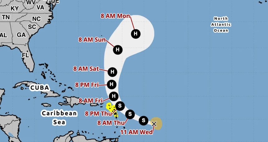
Tropical Storm Jerry became the 10th named storm of the 2025 Atlantic hurricane season on Tuesday, and it’s forecast to become a hurricane by the weekend, according to the National Hurricane Center.
Forecasters have put a tropical storm watch in place for parts of the Leeward Islands as Jerry is expected to pass near the area late Thursday and into the night.
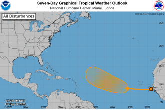
The NHC is also tracking a disturbance in the southwestern Gulf that is expected to produce areas of heavy rain and gusty winds during the next day or so over portions of southern Mexico. Its chances of forming into a cyclone over the next week are low.
Meanwhile, forecasters are tracking a nor’easter that’s putting the U.S. East Coast on alert for the potential for coastal flooding, heavy rain and strong winds over the weekend. “Over the next day or so, we expect high pressure to build into the Northeast, providing nice, albeit chilly, weather there,” the Weather Channel reported. “But along the Southeast Coast, including Florida, onshore winds will lead to areas of high surf, rip currents and coastal flooding at high tide, particularly from the Carolinas to eastern Florida even before the coastal storm forms.”
Where is Tropical Storm Jerry, and what is its path?
As of 11 a.m. ET on Wednesday:
-
Jerry was located about 750 miles east-southeast of the northern Leeward Islands.
-
The storm has maximum sustained winds of 60 mph.
-
It is moving west-northwest at 23 mph.
“A turn toward the northwest and then north at a slower forward speed is expected late Thursday into Saturday,” the NHC said.
AccuWeather lead hurricane expert Alex DaSilva added that “a dip in the jet stream along the East Coast of the United States is expected to help guide Jerry to the north and then curve it out to sea.”
What are the storm’s expected impacts affecting land?
From Thursday into Saturday morning, 2 to 4 inches of rain, with localized amounts up to 6 inches, are expected across the Leeward Islands, British Virgin Islands and U.S. Virgin Islands. With the rainfall comes a risk of flash flooding, the NHC said.
Swells caused by Jerry are likely to bring life-threatening surf and rip current conditions that are expected to reach the Leeward and Windward Islands on Thursday and then westward to the Greater Antilles on Friday, the NHC said.
What are the chances Jerry will intensify?
The NHC said Wednesday that strengthening is expected in the next few days, and Jerry could become a hurricane by the weekend.
A storm becomes a hurricane when maximum sustained winds reach at least 74 mph. Hurricanes are rated on a scale ranging from Category 1 to Category 5, with five being the most severe. A storm is considered a major hurricane when it reaches Category 3 strength, with sustained winds of at least 111 mph.
How is the 2025 Atlantic hurricane season shaping up?
The 2025 Atlantic hurricane season, which began June 1 and runs through the end of November, has a 50% chance of being above normal. We’re currently in the peak of hurricane season, which runs from mid-August through mid-October.
In early August, National Oceanic and Atmospheric Administration forecasters slightly updated the range of expected storms from 13-19 down to 13-18, of which up to five could become major hurricanes (with winds of more than 111 mph).
A typical hurricane season averages 14 named storms, and there’s about 25% left of this year’s Atlantic hurricane season. As of Oct. 8, there have been 10 named storms: tropical storms Andrea, Barry, Chantal, Dexter, Fernand and Jerry and hurricanes Erin, Gabrielle, Humberto and Imelda. The next named storm will be Karen.
How does this Atlantic hurricane season compare to past years?
This year marks the first time since 2015 that a hurricane has not made landfall through the month of September, according to AccuWeather. In years past, the following Atlantic hurricane seasons also went without a single hurricane making landfall in the U.S. through September: 2013, 2010, 2009, 2006, 2002, 2001 and 2000.
“Every hurricane season is different. This hurricane season so far is quite unique, with several close calls for the United States,” DaSilva said. “Erin was a major hurricane that stayed 200 miles off the coast of North Carolina in August. The Southeast was spared from major flooding from Hurricane Imelda in September, thanks in part to the rare Fujiwhara effect. Hurricane Humberto passed within 500 miles of Imelda and helped to pull the smaller storm away from the U.S. coast and out to sea.”
The only named Atlantic storm to make landfall in 2025 was Tropical Storm Chantal, which caused torrential rainfall that triggered record-breaking flooding in North Carolina back in July.
“Hurricane season is far from over. It’s important to remind everyone that the Atlantic hurricane season runs through the end of November. We have been forecasting a more active second half of the hurricane season since the spring,” DaSilva said. “Do not let your guard down. We expect atmospheric conditions that could support tropical storms and hurricanes well into late October and November this year.”