Invest 92L in the Atlantic has a high chance of becoming a tropical depression later this week, and some forecasters said it could become a tropical storm or even a hurricane.
If maximum sustained winds reach at least 39 mph, it would become Gabrielle, the seventh named storm of the Atlantic hurricane season.
➤ Track all active storms, Invest 92L
➤ Weather alerts via text: Sign up to get updates about current storms and weather events by location
As of Monday, Sept. 15, a dip in the jet stream could send any developing storm north into the Atlantic, keeping it away from North Carolina and the U.S. However, it’s still too early to tell exactly where the system is headed.
Here’s what you should know.
Spaghetti models for Invest 92L. See expected path
Special note about spaghetti models: Spaghetti model illustrations include an array of forecast tools and models, and not all are created equal. The Hurricane Center uses only the top four or five highest performing models to help make its forecasts.
Are there any storms in the Atlantic right now?
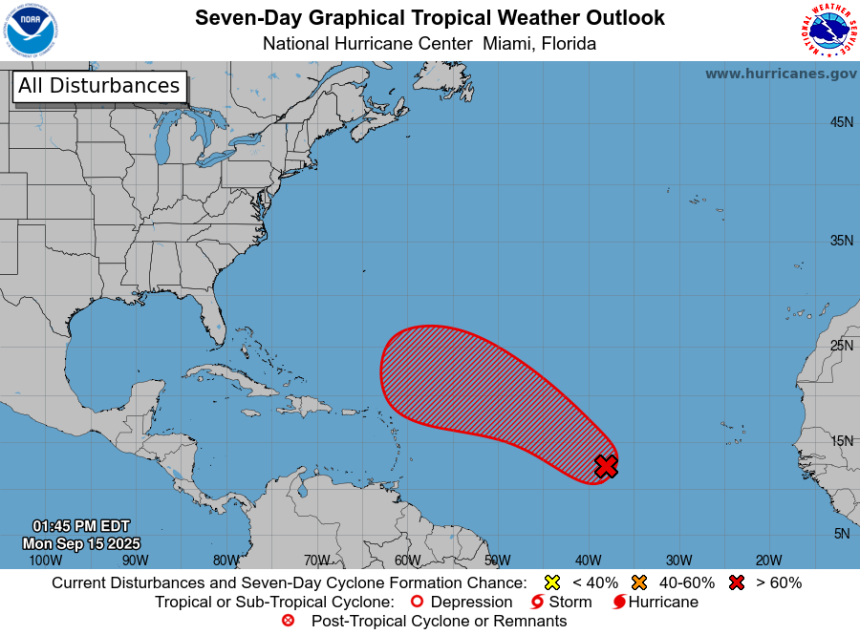
As of Monday afternoon, Sept. 15, there are no named storms in the Atlantic. However, the National Hurricane Center is monitoring one disturbance.
Disturbance 1:
-
Location: Central tropical Atlantic
-
Movement: West to west-northwest at 10 to 15 mph
-
Formation chance in 48 hours: Medium, 50%
-
Formation chance in 7 days: High, 90%
If maximum sustained winds reach at least 39 mph, it would become Tropical Storm Gabrielle, the seventh named storm of the 2025 Atlantic hurricane season.
The tropical wave located near the west coast of Africa is producing disorganized showers and thunderstorms over the far eastern Atlantic.
Environmental conditions appear conducive for some gradual development of this system over the next several days.
A tropical depression could form by the middle part of this week while it moves westward to west-northwestward at 10 to 15 mph over the eastern and central tropical Atlantic, according to the National Hurricane Center.
What tropical waves, disturbances are in Atlantic basin now?
Other tropical waves being monitored by National Hurricane Center:
The axis of an eastern Caribbean tropical wave is near 68W south of 20N. It is moving westward at around 17 mph. Scattered moderate convection is noted from 15N to 17N between 65W and 68W.
The axis of a central Atlantic tropical wave is near 48W from 01N to 20N. It is moving westward at around 11 to 17 mph. Scattered moderate and isolated strong convection is noted from 14N to 20N between 45W and 50W.
Track all storms in the Atlantic
Hurricane season set to ramp up by late September
While the basin has been quiet — even through the climatological peak — officials warn that activity is likely to increase as suppressing factors like dry air and wind shear begin to fade.
Of particular concern are storms that form close to the United States. Unlike tropical waves that roll off Africa and give forecasters days to track, systems that develop in the Gulf, Caribbean or off the Southeast coast can catch residents with little time to prepare.
These “homegrown” storms can also rapidly intensify in the Gulf’s extremely warm waters, AccuWeather forecasters said.
Are any hurricanes coming to North Carolina?
No. A new tropical disturbance has emerged, but it still is at medium chance for development — at 80% over the next seven days.
It’s also too early at this time to determine if there will be any impact to North Carolina or the U.S. from the other tropical waves out there.
Conditions can change rapidly, though, and forecasters warn residents to not become complacent and to always be prepared.
How does the 2025 Atlantic hurricane season compare to last year in North Carolina?
For North Carolina, the season has been quiet so far, following a similar pattern to 2024, although Hurricane Erin brought some significant impacts to the Outer Banks.
Around this time last year, Tropical Storm Debby brought heavy rain, flash flooding, tropical storm–force wind gusts, minor coastal flooding and three weak tornadoes to southeastern North Carolina after making landfall in Florida’s Big Bend region on Aug. 5, 2024, and then a second landfall in South Carolina’s Bulls Bay between Charleston and Georgetown early on Aug. 8, 2024.
By late September, the state tracked Tropical Storm Helene, which caused flash floods, landslides and hundreds of fatalities after moving through the Appalachians.
So far, no storms have directly affected the state, but Colorado State researchers say North Carolina has one of the highest odds of seeing impacts from a hurricane or named storm this season — second only to Florida.
When does the Atlantic hurricane season end in North Carolina?
The Atlantic hurricane season runs from June 1 through Nov. 30.
Ninety-seven percent of tropical cyclone activity occurs during this time period, NOAA said.
The Atlantic basin includes the northern Atlantic Ocean, Caribbean Sea and Gulf of America, as the Gulf of Mexico is now known in the U.S. per an order from President Donald Trump. NOAA and the National Hurricane Center are now using Gulf of America on its maps and in its advisories.
The peak of the season is Sept. 10, with the most activity happening between mid-August and mid-October, according to the Hurricane Center.
Prepare now for hurricanes
Delaying potentially life-saving preparations could mean waiting until it’s too late. “Get your disaster supplies while the shelves are still stocked, and get that insurance checkup early, as flood insurance requires a 30-day waiting period,” NOAA recommends.
-
Develop an evacuation plan: If you are at risk from hurricanes, you need an evacuation plan. Now is the time to begin planning where you would go and how you would get there.
-
Assemble disaster supplies: Whether you’re evacuating or sheltering-in-place, you’re going to need supplies not just to get through the storm but for the potentially lengthy aftermath, NOAA said.
-
Get an insurance checkup and document your possessions: Contact your insurance company or agent now and ask for an insurance check-up to make sure you have enough insurance to repair or even replace your home and/or belongings. Remember, home and renters insurance doesn’t cover flooding, so you’ll need a separate policy for it. Flood insurance is available through your company, agent, or the National Flood Insurance Program. Act now, as flood insurance requires a 30-day waiting period.
-
Create a family communication plan: NOAA says to take the time now to write down your hurricane plan and share it with your family. Determine family meeting places, and make sure to include an out-of-town location in case of evacuation.
-
Strengthen your home: Now is the time to improve your home’s ability to withstand hurricane impacts. Trim trees; install storm shutters, accordion shutters, and/or impact glass; seal outside wall openings.
North Carolina weather radar

North Carolina weather watches and warnings
Interactive map: Hurricanes, tropical storms that have passed near your city
Stay informed. Get weather alerts via text
Brandi D. Addison covers weather across the United States as the Weather Connect Reporter for the USA TODAY Network. She can be reached at baddison@gannett.com.
This article originally appeared on Asheville Citizen Times: Invest 92L spaghetti models. Will it become hurricane, tropical storm?