Tropical Storm Imelda is forecast to become the fourth hurricane of the 2025 Atlantic hurricane season on Tuesday, according to the National Hurricane Center. While it’s not expected to make landfall, the Southeastern U.S. could still see some heavy rainfall, flooding, storm surge and dangerous surf impacts, which have prompted the governors of South Carolina and North Carolina to declare a state of emergency.
The northwestern Bahamas are currently getting hit with heavy rainfall from Imelda, with 4 to 8 inches of rain predicted through Tuesday, which could result in flash and urban flooding. The storm is predicted to move northeast into the Atlantic and may hit Bermuda as a hurricane on Thursday morning.
Forecasters are also monitoring the path of Hurricane Humberto, which is a Category 4 storm that is expected to bring heavy rain to Bermuda on Tuesday as it continues to move northeast into the Atlantic Ocean.
Where is Tropical Storm Imelda, and what is its path?
As of 11 a.m. ET Monday:
-
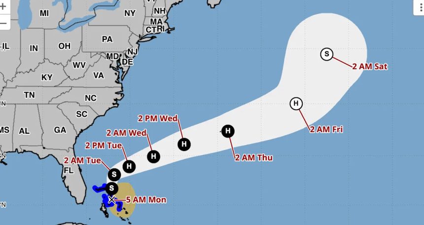
Imelda was located about 35 miles off Great Abaco Island in the Bahamas and about 240 miles east-southeast of Cape Canaveral, Fla.
-
The storm has maximum sustained winds of 60 mph.
-
It is moving north at 9 mph.
On Monday, Imelda is expected to continue to move northward, with the center of the storm moving away from the northwestern Bahamas. On Tuesday, it’s forecast to make a sharp turn to the east-northeast. By midweek, the tropical storm is expected to move away from the Southeastern U.S. but will approach the island of Bermuda.
What are the storm’s expected impacts?
Northeast Florida, coastal South Carolina and coastal sections of southeast North Carolina could see 1 to 2 inches of rainfall, with some local maximum amounts of 4 inches, through Tuesday. Isolated flash and urban flooding could result from the storm’s rainfall.
“Minor coastal flooding is possible in areas of onshore winds over the Southeastern U.S. coastline,” the National Hurricane Center said in its latest Monday advisory. The water could reach 1 to 2 feet above ground from the Volusia/Brevard County Line in Florida to the South Santee River in South Carolina if the surge happens over the next several high tide cycles, forecasters say.
Swells caused by Imelda, along with Hurricane Humberto, will cause life-threatening surf and rip current conditions along the U.S. East Coast early this week.
What are the chances it will intensify?
NHC forecasters predict Tropical Storm Imelda will continue to strengthen and will become a hurricane on Tuesday.
A tropical storm becomes a hurricane when maximum sustained winds reach at least 74 mph. Hurricanes are rated on the Saffir-Simpson Hurricane Wind Scale, ranging from Category 1 to Category 5, with 5 being the most severe. A storm is considered a major hurricane when it reaches Category 3 strength, with sustained winds of at least 111 mph, according to the NHC.
Watches and warnings in place
As of 11 a.m. ET Monday, these are the following advisories in place, according to the NHC:
Tropical storm warnings are in effect for:
-
Portions of the Northwestern Bahamas, including Eleuthera, the Abacos, Grand Bahama Island and the surrounding keys.
Forecasters added that “a Tropical Storm Warning means that tropical storm conditions are expected somewhere within the warning area, in this case within 12 hours.”
The NHC advised that Bermuda should continue to monitor the progress of Imelda and hurricane watches could be required for the island as soon as Monday afternoon.
Could Hurricane Humberto and Tropical Storm Imelda combine to form one storm?
Humberto and Imelda could become part of a weather phenomenon known as the Fujiwhara Effect, which is what happens “when two hurricanes spinning in the same direction pass close enough to each other, they begin an intense dance around their common center,” the National Weather Service explains.
In this instance, the Fujiwhara Effect could help prevent the U.S. East Coast from getting slammed.
“The rare Fujiwhara Effect between Humberto and Imedla is expected to help spare the Southeast U.S. from widespread flooding rainfall,” explained AccuWeather’s lead hurricane expert, Alex DaSilva. “The influence from the much stronger and larger Humberto will tug at Imelda and help pull the storm away from the U.S. and out to sea.”
“It’s quite rare to see the Fujiwhara Effect in the Atlantic basin. The interaction between the two storms should prevent Imelda from making landfall or stalling near the coast, which could have led to days of torrential rainfall and widespread flooding,” DaSilva said. “The impacts could have been catastrophic.”