Severe weather is forecast to return to parts of the Mississippi Valley this weekend, with a threat of damaging winds, hail and even a few tornadoes breaking a relatively quiet stretch for the U.S. this fall.
Forecast Timing
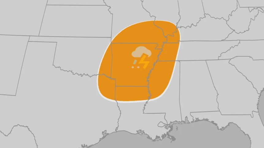
– Friday afternoon, evening: Thunderstorms are forecast to become more numerous in the Plains from southeast Nebraska and Iowa into western Missouri, eastern Kansas, Oklahoma and western Arkansas.
– Saturday: Severe thunderstorms are most likely during the day from eastern Oklahoma and southern Missouri into Arkansas, northeast Texas and northern Louisiana.
– Saturday night: The severe threat may continue and stretch from southern Illinois and western Kentucky into western and Middle Tennessee, Mississippi, Louisiana and Alabama.
– Sunday: The severe threat appears lower Sunday, but thunderstorms are in the forecast from Georgia and the Carolinas to the northern Gulf Coast.
(MAPS: Daily Rain, Thunderstorm US Forecasts)
Saturday’s Severe Weather Outlook
Threats
– The main severe weather threat appears to be damaging wind gusts capable of tree damage and power outages Saturday and Saturday night in the areas mentioned above.
– While this does not appear to be a large outbreak, there is a threat of a few tornadoes, both embedded within any lines or clusters of thunderstorms, and with any supercell thunderstorms that may form.
– Some large hail is possible in the strongest storms.
– Locally flooding rain is also possible in the middle and lower Mississippi Valley Saturday and Saturday night.
What You Should Do
It has been awhile since a more concentrated severe weather threat has been on the table.
The key is to first be aware of the threat, when it could happen, and have a plan to seek safe shelter.
Have multiple ways of receiving severe weather watches and warnings from the National Weather Service, including from an app like The Weather Channel app, NOAA weather radio, or local TV and radio.
Make sure your smartphone and NOAA weather radio are fully charged and any “do not disturb” function is turned off at night, so an overnight alert can wake you up.
(MORE: Tornado Safety Tips | What If No Basement | Dangers Of Severe Thunderstorms)
A Quiet Stretch
It’s not your imagination. It has been rather quiet, recently, on the severe thunderstorm front.
The map below shows the total number of severe thunderstorm reports — including tornado reports — so far in October. It’s far short of 100 total reports nationwide in the first half of October.
October usually isn’t an active severe weather month. It averaged only 59 tornadoes over the past 20 years.
So far, the month has been dominated by expansive high pressure aloft over the Great Lakes, Ontario and Quebec, Canada, the Northeast and Plains states. That’s a pattern of warmth, but suppressive of thunderstorms.
And when that pattern hasn’t been in place, cool, fall air has plunged into the eastern two-thirds of the country, taking thunderstorms off the table.
We’ve also had a complete lack of tropical storms and hurricanes in the U.S. since short-lived Chantal moved into the Carolinas in early July. These landfalling storms can be a significant source of tornadoes in the fall, as we saw last October with Hurricane Milton in Florida.

October severe weather 2025
Jonathan Erdman is a senior meteorologist at weather.com and has been covering national and international weather since 1996. Extreme and bizarre weather are his favorite topics. Reach out to him on Bluesky, X (formerly Twitter) and Facebook.