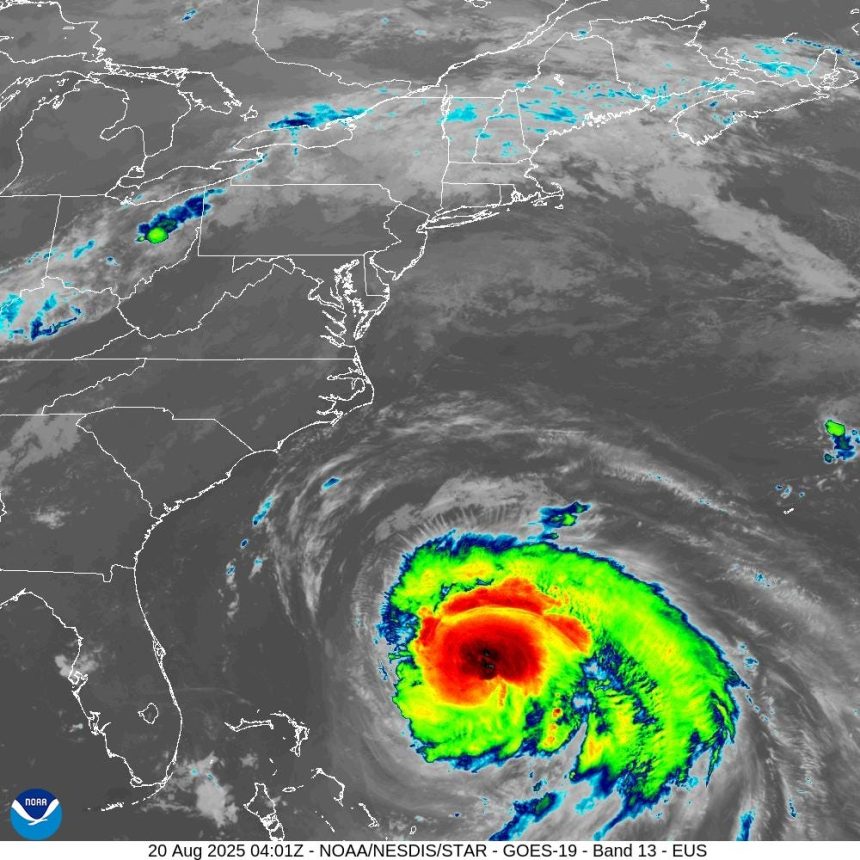
Hurricane Erin weakened overnight, but still remains a category 2 storm and could strengthen today as it moves up the East Coast, according to the National Hurricane Center.
As of 2 p.m. Aug. 20, Erin was located about 455 south-southeast of Cape Hatteras, North Carolina. It had sustained winds of 100 mph and is moving north-northwest at 13 mph. It will start making its turn north on Aug. 20, followed by a faster motion toward the northeast and east-northeast by Aug. 21 and 22.
Hurricane Erin, moving along the U.S. East Coast on the evening of Aug. 1, is forecast to stir up rough conditions at Atlantic beaches for at least 48 hours.
The National Hurricane Center said early on Aug. 20 that the storm had reformed an inner eye wall, and a Hurricane Hunter mission this morning is expected to help the center determine if winds have increased in response.
“Erin is a large hurricane and growing,” the weather service said the morning of Aug. 20.
The center of Erin will move over the western Atlantic between the U.S. east coast and Bermuda Aug. 20, and then pass south of Atlantic Canada this weekend.

The forecasted path of Hurricane Erin
When is Hurricane Erin supposed to hit Delaware?
Even though Erin is expected to stay hundreds of miles offshore, its impacts are forecast to worsen as it crawls northward and makes its closest approach to the U.S. mainland.
Erin may strenghthen Aug. 20 and 21 and bring dangerous rip currents as it passes Delaware.
Delaware’s Atlantic coastline is under a high risk for rip currents. Tropical storm force gusts are possible along the Delaware coast on Aug. 21, with breaking waves of 5 to 8 feet on Aug. 20 and 7 to 11 feet on Aug. 21.
Widespread minor to moderate coastal flooding is forecast for Aug. 21 and 22 during evening high tides. Locally major coastal flood impacts are possible in Kent and Sussex Counties.
Hurricane Erin causes Delaware beaches to halt swimming
As Hurricane Erin gets closer, Delaware beaches are closed to swimmers. Due to rip currents and rough surf, ocean access was closed in Rehoboth, Dewey and Bethany beaches Aug. 19. The beach remains open in all three towns.
Rehoboth Beach lifeguards are prepared to keep the beach closed to swimmers through Aug. 22 but will assess conditions daily, Rehoboth spokesperson Erin Corcoran said.
In Bethany Beach, there is a possibility of full beach closures later in the week, Bethany Beach Patrol Captain Joe Donnelly said.
At Delaware State Parks, all the guarded beaches are closed to swimmers, spokesperson Beth Kuhles-Heiney said. That includes:
-
Cape Henlopen State Park main beach
-
Tower and South Inlet beaches in Delaware Seashore State Park
-
Fenwick Island State Park beach
Hurricane Erin tracker?
This forecast track shows the most likely path of the center of the storm. It does not illustrate the full width of the storm or its impacts, and the center of the storm is likely to travel outside the cone up to 33% of the time.
What’s next behind Hurricane Erin?
Following behind Erin is yet another tropical wave that’s given a 60% chance of becoming a tropical storm over the next seven days, the hurricane center said. A third disturbance just moved off the West African coast, but it’s expected to encounter hostile conditions that may limit its further development.
What is a rip current?
According to NOAA, rip currents are channeled currents of water that flow away from the shore out past the line of breaking waves. They form from water piling up between the breaking waves and the beach. As the water returns from the shore, it forms a narrow stream of water that moves quickly out to sea.
What to do in a rip current

A poster explaining how to recognize and escape a rip current.
According to the United States Lifesaving Association, swimmers should do the following:
-
Relax, rip currents don’t pull you under.
-
Don’t swim against the current.
-
You may be able to escape by swimming out of the current in a direction following the shoreline, or toward breaking waves, then at an angle toward the beach.
-
You may be able to escape by floating or treading water if the current circulates back toward shore.
-
If you feel you will be unable to reach shore, draw attention to yourself. If you need help, yell and wave for assistance.
When is hurricane season?
Hurricane season runs from June 1 through Nov. 30. However, hurricanes can occur before and after those dates.
What are the categories for tropical cyclones and hurricanes?
Tropical storm
A tropical storm is a tropical cyclone with winds between 39 and 73 mph. These storms bring heavy rains that could lead to dangerous flooding.
Category 1
A category 1 storm is the weakest of the hurricanes with winds between 74 and 95 mph. The storm will cause some flooding, but no real structural damage.
Category 2
A category 2 storm has winds between 96 and 110 mph. The storm can cause moderate damage to buildings.
Category 3
A category 3 storm will have winds from 111-129 mph. It can cause major damage to well-built framed homes, uproot trees and cause power and communication outages.
Category 4
A category 4 storm can cause catastrophic damage to well-built framed homes, tearing off roofs and breaking exterior walls. Mobile homes are destroyed. Roads are impassible and there are communication and power outages.
Category 5
A category 5 storm can cause catastrophic damage with most framed homes and mobile homes being destroyed. Trees will be snapped and uprooted. Roads will be impassible and there will be extended power and communication outages.
This article originally appeared on Delaware News Journal: Where is Hurricane Erin? Tracker, forecast, path for category 2 storm