A storm bringing rounds of heavy showers and gusty thunderstorms to the interior Southwest through midweek will shift eastward into the Plains later this week, increasing the risk for severe thunderstorms and flash flooding, AccuWeather meteorologists say.
As the storm moves east, it will encounter warm, moist air being drawn northward from the Gulf, fueling intense thunderstorm development.
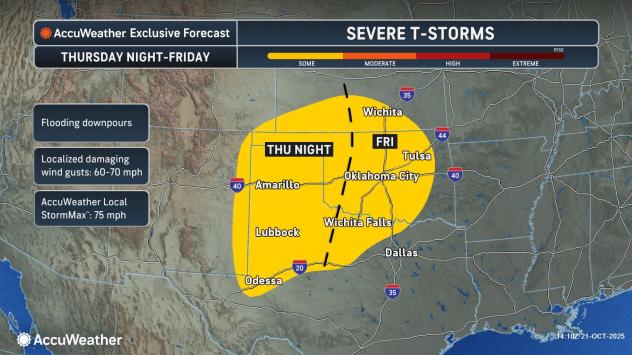
Thunderstorms may begin to reach severe levels as early as Thursday night across eastern New Mexico, northwestern Texas and southwestern Kansas.
AccuWeather.com
The severe weather threat will continue to drift eastward and increase somewhat during the day on Friday from north-central Texas to central Oklahoma and south-central Kansas. While a few tornadoes are possible, the primary threats will be damaging wind gusts and flash flooding from torrential downpours.
Flash flood risk to increase farther east
As the storm progresses slowly from the High Plains to the Ozark Mountains, heavy rainfall will become a more widespread danger. Rainfall totals could reach 4-6 inches in pockets, raising the risk for flash flooding in urban areas and along small streams.
Since much of the rain will fall on a zone where the ground is dry due to months of drought, the rain will generally be absorbed by the landscape and may be of benefit. Because of low levels on tributary rivers, any boost to low water levels on the Mississippi River may be slight and of short duration.

AccuWeather.com
Motorists are urged to exercise extra caution along Interstates 30, 35, 40 and 44 in the region. Due to steep terrain in some areas, flash flooding poses a significant risk to campers in the Ozark Mountains. Several inches of rain in a short period may cause sudden and dangerous rises in water levels.
As the weekend progresses, some downpours will extend farther to the east along the Interstate 10 and 20 corridors in the Gulf Coast states, but the risk for flash flooding is expected to decrease and become more localized by late weekend in the Mississippi Delta region and the central Gulf Coast.
AccuWeather meteorologists are tracking a strengthening Tropical Storm Melissa in the Caribbean. While Melissa is not expected to impact the U.S. Gulf Coast from the Florida Panhandle to Texas, some indirect tropical impacts could still reach the U.S. Atlantic Coast later this month. There is the risk of significant direct impacts in South Florida.
Melissa may bring life-threatening impacts, including flooding and damaging winds, to parts of the Caribbean before any approach to the U.S. next week.
Want next-level safety, ad-free? Unlock advanced, hyperlocal severe weather alerts when you subscribe to Premium+ on the AccuWeather app. AccuWeather Alerts™ are prompted by our expert meteorologists who monitor and analyze dangerous weather risks 24/7 to keep you and your family safer.