The National Weather Service in Wilmington says some welcome rain forecast for most of the week across a drought-stricken Ohio could bring with it some severe weather.
The agency issued a hazardous weather outlook for most of central and southern Ohio, including Columbus and most of the surrounding counties.
The outlook issued at 9:21 a.m. Sept. 22 includes the following Ohio counties: Franklin, Auglaize, Darke, Shelby, Logan, Delaware, Miami, Champaign, Clark, Madison, Licking, Preble, Montgomery, Greene, Pickaway, Fairfield, Butler, Warren, Clinton, Ross, Hocking, Hamilton, Clermont, Brown, Highland, Adams, Pike and Scioto.
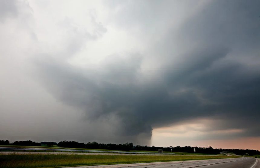
The NWS says the storms are expected to begin moving through the region beginning in the afternoon and early evening depending on where you live in the warning region. The most considerable threat could include heavy winds.
The severe weather outlook comes a day after the NWS issued several warnings for other parts of central Ohio. The week of rain forecasts come amid a historic dry spell that has impacted crops and livestock throughout the state.
Will rain help the drought conditions in Ohio?
The U.S. Drought Monitor’s map of Ohio released on Sept. 18.
In a previous interview with The Dispatch, NWS meteorologist John Franks said the upcoming rain and storms will likely be too sporadic to alleviate the moderate drought Columbus, a most of Ohio is currently experiencing.
Much of the state’s drought conditions became more severe, from abnormally dry conditions to moderate drought, in its most recent Sept. 16 projections.
“Any rain is going to be beneficial, but what we’re looking at in the upcoming forecast is not an all-day soaker,” he said.
The entire state is currently experiencing some level of dryness measured on the U.S. Drought Monitor’s drought scale. Ohio’s drought could continue through the fall and into the winter. A NOAA projection released Sept. 18 predicts the drought will continue until at least Dec. 31.
Columbus, central Ohio current weather radar

How do I track power outages in Columbus?
With severe winds forecast in the hazardous weather outlook, there is an increased likelihood of sporadic and scattered power outages. Columbus area business and residents receive energy from one of two power companies:
AEP Ohio, which services much of the Columbus area, has an online power outage map available on its website.
For Columbus Division of Power customers, the city has its own outage map available online.
What’s the difference between thunderstorm warning and watch?
The National Weather Service breaks its weather alerts into two categories: watches and warnings. One is a sign to keep your eyes and ears open for any sudden changes in the strength of storms, and the other is more urgent.
A severe thunderstorm watch means it’s time to prepare for bad storms, the NWS says.
“Severe thunderstorms are possible in and near the watch area. Stay informed and be ready to act if a severe thunderstorm warning is issued. The watch area is typically large, covering numerous counties or even states.”
A severe thunderstorm warning means it’s time to act, according to the agency.
This means, “Severe weather has been reported by spotters or indicated by radar. Warnings indicate imminent danger to life and property. Take shelter in a substantial building. Get out of mobile homes that can blow over in high winds. Warnings typically encompass a much smaller area (around the size of a city or small county) that may be impacted by a large hail or damaging wind identified by an NWS forecaster on radar or by a trained spotter/law enforcement who is watching the storm.”
Columbus forecast for the week of Sept. 22, 2025
Rain will highlight much of this week’s forecast, according to the NWS. Of course, like most of the weather, these predictions can change as the week progresses. These forecasts are for John Glenn Columbus International Airport in Columbus. Check your local forecast for more details.
-
Monday night, Sept. 22: There’s an 80% percent chance of showers and thunderstorms possible with low temperatures around 65 degrees. Expect south wind of around 6 p.m.
-
Tuesday daytime, Sept. 23: An 80% chance of thunderstorms with high temperatures near 78 degrees. Southwest winds of 6 to 8 mph.
-
Tuesday night, Sept. 23: A 60% chance of more showers likely before 11 p.m. continuing through about 2 a.m. Expect low overnight temperatures of around 65 degrees and west wind around 5 mph.
-
Wednesday daytime, Sept 24: More showers expected with a 70% chance of rain after 2 p.m. Expect high temperatures of around 77 degrees and southeast winds from 5 to 8 mph.
-
Wednesday night, Sept 24: Showers and possibly a thunderstorm. Low around 65. Chance of precipitation is 80%. New rainfall amounts between a half and three quarters of an inch possible.
-
Thursday daytime, Sept 25: Showers likely. Mostly cloudy, with a high near 76. Chance of precipitation is 60%.
-
Thursday night, Sept 25: A 30% chance of showers before 2 a.m. Mostly cloudy, with a low around 60 degrees.
-
Friday daytime, Sept 26: A 30% chance of showers after 2 p.m. Partly sunny, with a high near 76 degrees.
-
Friday night, Sept 26: A 30% chance of showers before 8 p.m. Partly cloudy, with a low around 57 degrees.
-
Saturday daytime, Sept 27: A 30% chance of showers. Mostly sunny, with a high near 78 degrees.
-
Saturday night, Sept 27: A 30% chance of showers. Mostly clear, with a low around 57 degrees.
This article originally appeared on The Columbus Dispatch: Columbus, central Ohio weather forecast thunderstorms, rain amid drought