Forecasters predict Tropical Storm Gabrielle will become the season’s second hurricane but on Thursday, Sept. 18, it was struggling.
As expected, Gabrielle is running into wind shear and dry air, both of which are preventing the storm from strengthening. Environmental conditions are expected to remain “hostile” for development for a couple more days and Gabrielle will either “hold steady or lose strength,” according to the National Hurricane Center.
➤ Weather alerts via text: Sign up to get updates about current storms and weather events by location
By late this weekend or early next week, though, conditions are expected to favor Gabrielle, which is expected to become more symmetrical and strengthen into a hurricane.
Gabrielle is the seventh named storm of the 2025 Atlantic hurricane season and the first tropical storm since Tropical Storm Fernand formed Aug. 23.
If it does become a hurricane, it will be only the second hurricane of the season.
Erin became the season’s first hurricane more than a month ago, on Aug. 15, and rapidly intensified into a major hurricane with peak winds hitting 160 mph the next day.
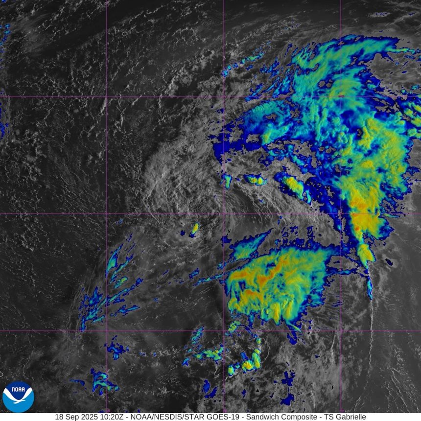
Highlights on what Tropical Storm Gabrielle is doing now
Special note on the NHC cone: The forecast track shows the most likely path of the center of the storm. It does not illustrate the full width of the storm or its impacts, and the center of the storm is likely to travel outside the cone up to 33% of the time.
-
Location: 845 miles east of the northern Leeward Islands; 1,938 miles east of West Palm Beach
-
Maximum sustained winds: 50 mph
-
Movement: west-northwest at 15 mph
Will Tropical Storm Gabrielle become a hurricane?
At 5 a.m., the center of Tropical Storm Gabrielle was located near latitude 20.0 North, longitude 50.3 West.
Gabrielle is moving toward the west-northwest near 15 mph. A west-northwest or northwest motion is expected during the next few days.
Maximum sustained winds remain near 50 mph, with higher gusts.
Little change in strength is forecast during the next 48 hours, but some gradual intensification is forecast late in the weekend.
Tropical-storm-force winds extend outward up to 240 miles, from the center.
The estimated minimum central pressure is 1004 mb.
Will Tropical Storm Gabrielle impact South Carolina? See path
That’s unknown at this time, although current forecasts continue to predict Gabrielle will curve north in the Atlantic and stay away from South Carolina and the United States.
Gabrielle “isn’t the most picturesque tropical storm on satellite this afternoon by any stretch as it battles against dry and dusty air,” said Fox Weather meteorologist Ian Oliver via email Sept. 17.
“However, conditions will become increasingly favorable for intensification and Gabrielle is forecast to be a hurricane somewhere near or east of Bermuda early next week.”
“I think that if the storm is able to strengthen into a hurricane, which we currently have projected, we could see some beach issues next week, middle to end of next week, along the east coast. And that’s anywhere from Florida all the way up to New England,” according to Alex DaSilva, AccuWeather lead hurricane expert via email Sept. 17.
“That’s something we’re going to have to watch for. If the storm stays relatively weak, if it never gets to a hurricane, then we probably won’t have any beach hazards, but if it really intensifies north of the Caribbean and becomes a hurricane, we do have to be concerned for some rip current risks along the east coast next week.
“It could be a beautiful sunny day at the beach, but even if there’s a hurricane hundreds and hundreds of miles away, we can still see issues from rip currents,” DaSilva said.
Residents in Bermuda are advised to watch the system closely.

Tropical Depression Seven has formed in the Atlantic and is expected to become Tropical Storm Gabrielle by the end of the day on Wednesday, Sept. 17, according to the National Hurricane Center.
Spaghetti models for Tropical Storm Gabrielle
Special note about spaghetti models: Spaghetti model illustrations include an array of forecast tools and models, and not all are created equal. The Hurricane Center uses only the top four or five highest performing models to help make its forecasts.
What tropical waves, disturbances are in Atlantic basin now?
Tropical wave in east-central tropical Atlantic:
-
Formation chance through 48 hours: low, 10 percent.
-
Formation chance through 7 days: low, 20 percent.
Other tropical waves being monitored by National Hurricane Center:
A western Caribbean Sea tropical wave is near 87W from 21N southward, moving west around 11 mph. With abundant tropical moisture, scattered showers and isolated strong thunderstorms are noted over the Gulf of Honduras, western Honduras, and Caribbean waters W of 80W.
A far eastern Atlantic tropical wave is near 27W from 19N southward across the western Cabo Verde Islands, moving west around 17 mph. Scattered moderate convection is noted from 14N to 17N between 25W and 29W.
A eastern Caribbean Sea tropical wave is near 69W from 22N southward across eastern Hispaniola to northwestern Venezuela, moving west at 17 to 23 mph. Scattered moderate convection is occurring across Hispaniola, Puerto Rico, the Virgin Islands and nearby waters.
Will Hurricane Gabrielle form in the Atlantic? Hurricane tracker
Hurricane season set to ramp up by late September
While the basin has been quiet — even through the climatological peak — officials warn that activity is likely to increase as suppressing factors like dry air and wind shear begin to fade.
Of particular concern are storms that form close to the United States. Unlike tropical waves that roll off Africa and give forecasters days to track, systems that develop in the Gulf, Caribbean or off the Southeast coast can catch residents with little time to prepare.
These “homegrown” storms can also rapidly intensify in the Gulf’s extremely warm waters, AccuWeather forecasters said.
Are any hurricanes coming to South Carolina?
No. Tropical Storm Gabrielle is the only named storm in the Atlantic currently.
Conditions can change rapidly, though, and forecasters warn residents to not become complacent and to always be prepared.
When does the Atlantic hurricane season end in South Carolina?
The Atlantic hurricane season runs from June 1 through Nov. 30.
Ninety-seven percent of tropical cyclone activity occurs during this time period, NOAA said.
The Atlantic basin includes the northern Atlantic Ocean, Caribbean Sea and Gulf of America, as the Gulf of Mexico is now known in the U.S. per an order from President Donald Trump. NOAA and the National Hurricane Center are now using Gulf of America on its maps and in its advisories.
The peak of the season is Sept. 10, with the most activity happening between mid-August and mid-October, according to the Hurricane Center.
Prepare now for hurricanes
Delaying potentially life-saving preparations could mean waiting until it’s too late. “Get your disaster supplies while the shelves are still stocked, and get that insurance checkup early, as flood insurance requires a 30-day waiting period,” NOAA recommends.
-
Develop an evacuation plan: If you are at risk from hurricanes, you need an evacuation plan. Now is the time to begin planning where you would go and how you would get there.
-
Assemble disaster supplies: Whether you’re evacuating or sheltering-in-place, you’re going to need supplies not just to get through the storm but for the potentially lengthy aftermath, NOAA said.
-
Get an insurance checkup and document your possessions: Contact your insurance company or agent now and ask for an insurance check-up to make sure you have enough insurance to repair or even replace your home and/or belongings. Remember, home and renters insurance doesn’t cover flooding, so you’ll need a separate policy for it. Flood insurance is available through your company, agent, or the National Flood Insurance Program. Act now, as flood insurance requires a 30-day waiting period.
-
Create a family communication plan: NOAA says to take the time now to write down your hurricane plan and share it with your family. Determine family meeting places, and make sure to include an out-of-town location in case of evacuation.
-
Strengthen your home: Now is the time to improve your home’s ability to withstand hurricane impacts. Trim trees; install storm shutters, accordion shutters, and/or impact glass; seal outside wall openings.
South Carolina weather radar

South Carolina weather watches and warnings
Interactive map: Hurricanes, tropical storms that have passed near your city
Stay informed. Get weather alerts via text
Brandi D. Addison covers weather across the United States as the Weather Connect Reporter for the USA TODAY Network. She can be reached at baddison@gannett.com.
This article originally appeared on Greenville News: South Carolina hurricane tracker. Where is Tropical Storm Gabrielle?