Florida and the Bahamas will see rain and blustery winds throughout the day Sunday and Monday from what is now Tropical Storm Imelda — with the most intense conditions over the islands, which were under a tropical storm warning.
Much of the Bahamas are expected to be soaked — with 6 to 12 inches of rain in the heaviest spots near the northwest — and be swept by winds of 45 mph and up.
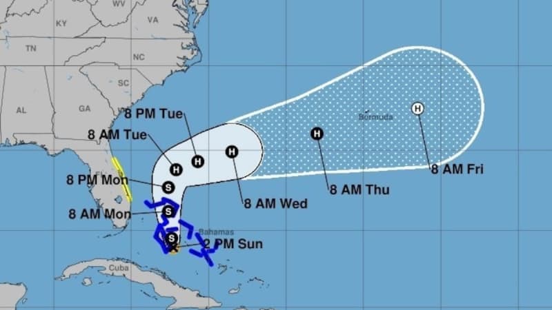
South Florida is likely to see far less rain and experience weaker winds, as overnight updates from the National Hurricane Center nudged the forecast track east again, keeping its core farther offshore.
“While it is too early to feel extremely confident, almost all of the reliable ensembles now keep the system offshore of the southeastern United States, though some impacts are still anticipated,” forecasters wrote early Sunday morning.
The Miami office of the National Weather Service called for “periods of showers and storms throughout the day Sunday” as the storm crawls up the coast. The weather service in Tampa Bay said “no significant impacts are expected at this time” for west-central and southwest Florida.
Ana Torres-Vazquez, a meteorologist at the Miami office of the National Weather Service, said the worst of the system will likely be past South Florida by midday Monday, unless some of the trailing bands of rain and thunderstorms end up sweeping over the region.
“Right now, with the storm remaining farther east, it’ll all come down to how those outer areas set up and which way they move,” she said. “It’s still a sloppy mess.”
South Florida is expected to see 1 or 2 inches of rain Sunday and Monday, she said. But if those lagging rain bands arrive, some isolated spots could see up to 4 inches of rain.
Much of east-central Florida— from Martin County north to Volusia County — remained under a tropical storm watch. The coastal areas there could see some gusts of moderately high winds — around 40 to 50 mph — as the system passes to the east on Monday and Tuesday.
Sunday morning, National Hurricane Center director Michael Brennan said those watches and warnings could be discontinued as soon as Sunday afternoon if trends nudging the storm’s track east continue.
As of 2 p.m. Sunday, the hurricane center upgraded the system into Tropical Storm Imelda. The last major forecast update also included another nudge of the track to the south and east, increasing the distance from the Florida coast.
The latest forecast shows Imelda creeping along Florida’s coast for the next few days — a slowdown from Saturday’s forecast.
That slower track is helpful to residents along the Southeast coast of the U.S., forecasters said, because it allows the weaker, slower Imelda to be influenced by the much more powerful Category 4 Hurricane Humberto.
That explains the sharp right hook in Imelda’s forecast track, instead of a once-predicted landfall in the Carolinas.
However, the hurricane center warned, the storm is large and slow enough that even if it does get yanked out to sea, it will likely dump a ton of rain on coastal swaths of the region.
• • •
Tampa Bay Times hurricane coverage 2025
Here’s a look at the 2025 hurricane season forecasts so far.
What to know about river flooding in Tampa Bay this hurricane season.
Here are the lessons you learned from Tampa Bay’s historic 2024 hurricane season.