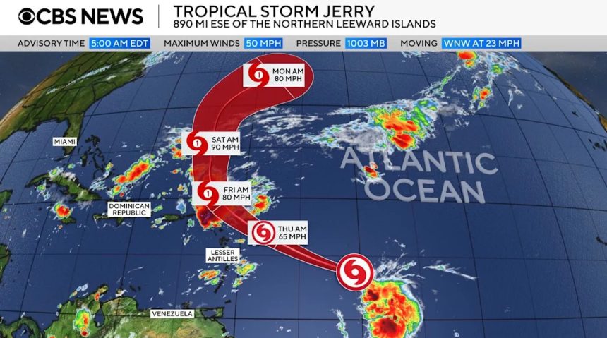
Tropical Storm Jerry continued to churn early Wednesday over tropical waters of the central Atlantic Ocean, the Miami-based National Hurricane Center said, a day after it formed. Jerry is the 10th named storm of the 2025 Atlantic hurricane season.
The new system was far from land. The center said Jerry was some 890 miles east-southeast of the northern Leeward Islands, the Caribbean chain east of Puerto Rico that starts with the Virgin Islands and extends down to Guadeloupe.
/ Credit: Nikki Nolan / CBS News
Jerry had maximum sustained winds of 50 mph as it hurried west-northwest at 23 mph across the open ocean, according to forecasters. It was expected to strengthen and become a hurricane on Thursday, meaning it would have minimum sustained winds of 74 mph.
A tropical storm watch was in effect for Antigua, Barbuda, Anguilla, St. Kitts, Nevis, and Montserrat, St. Barthelemy, St. Martin, Saba and St. Eustatius, Guadeloupe and the islands adjacent to it.
On its forecast track, Jerry’s core is forecast to be near or north of the northern Leeward Islands late Thursday and Friday, the hurricane center said. It wasn’t posing any threat to southern Florida.
“On Thursday into early Friday, two-to-four inches of rain are expected across the Leeward Islands due to Jerry,” the center said. “This rainfall brings a risk of flash flooding, especially in areas of higher terrain.”
In addition, the center noted, Jerry-generated swells “re expected to reach the Leeward and Windward Islands on Thursday, then spread westward toward the Greater Antilles on Friday. These swells are likely to cause life-threatening surf and rip current conditions.”
Jerry developed on the heels of several Atlantic storms, including Hurricane Humberto and Hurricane Imelda, which emerged at the end of September. Concerns that both could strike Bermuda briefly circulated, but only Imelda ultimately brushed the coast of the island as a Category 2 hurricane before quickly weakening on its way out to the open ocean.
Humberto and Imelda also hit the southeastern United States with destructive surf, causing multiple coastal homes in North Carolina’s Outer Banks to collapse.
This has been a relatively quiet hurricane season, which typically runs annually from June 1 to Nov. 30 in the Atlantic. While Jerry is the 10th named storm this year, just one of the nine others — Chantal — actually made landfall in the U.S.
When the current season began, an outlook released by the National Oceanic and Atmospheric Administration indicated that between 13 and 19 named storms would form in the Atlantic, with up to nine becoming hurricanes and as many as five strengthening into powerful Category 5 storms. But, as the months progressed, NOAA revised its outlook in August to predict that 13 to 18 named storms would form, including five to nine hurricanes.
Texas National Guard troops arrive in Illinois ahead of expected Chicago deployment
Utah lawmakers push through new congressional maps favoring GOP
Behind the invention of the service dog concept 50 years ago