Tropical Storm Melissa is likely to undergo “rapid intensification” and grow into a powerful Category 4 hurricane, according to the latest advisory from the National Hurricane Center.
“As Melissa intensifies, its wind field is expected to grow and become more symmetric.”
➤ Track Tropical Storm Melissa
➤ Weather alerts via text: Sign up to get updates about current storms and weather events by location
Melissa continues to move very slowly in the central Caribbean, which means residents in Haiti, Jamaica, and eastern Cuba face days of wind and heavy rainfall.
Florida residents should keep a wary eye on the storm. Forecasts are proving to be challenging, and models spread widely on where Melissa could go and how strong it could get.
Melissa is expected to strengthen into a major hurricane over the weekend or early next week, according to the Hurricane Center.
A major hurricane is one that’s at least a Category 3 storm, with maximum sustained winds of 111 mph. Current forecasts are for Melissa to become a Category 4 hurricane with 130-mph winds early next week.
Could Melissa impact Florida?
“The longer Melissa tracks to the west, the greater the chance of an impact on the U.S.,” said AccuWeather Chief Meteorologist Bernie Rayno said.
“The longer Melissa tracks to the west, the greater the chance of an impact on the U.S.,” said AccuWeather Chief Meteorologist Bernie Rayno.
“The chances of a direct U.S. hit from Melissa are low right now, but it is still an option, should the tropical system make it into the western Caribbean,” said AccuWeather Lead Hurricane Expert Alex DaSilva.
As for areas farther to the north along the U.S. East Coast, there is some risk of impacts, even if the center remains at sea, AccuWeather said.
Here’s what you should know.
Highlights on what Tropical Storm Melissa is doing now
Special note on the NHC cone: The forecast track shows the most likely path of the center of the storm. It does not illustrate the full width of the storm or its impacts, and the center of the storm is likely to travel outside the cone up to 33% of the time.
-
Location: 240 miles south-southwest of Kingston, Jamaica; 300 miles southwest of Port Au Prince, Haiti; 889 miles southeast of Naples
-
Maximum sustained winds: 50 mph
-
Movement: west-northwest at 3 mph
Tropical Storm Melissa: What you need to know
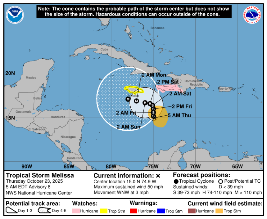
At 5 a.m., the center of Tropical Storm Melissa was located near latitude 15.0 North, longitude 74.9 West.
Melissa is moving toward the west-northwest near 3 mph. A slow northwest or north motion is forecast during the next couple of days, followed by a westward turn over the weekend.
On the forecast track, Melissa is expected to be nearer to Jamaica and the southwestern portion of Haiti during the next couple of days.
Maximum sustained winds are near 50 mph, with higher gusts. Tropical-storm-force winds extend outward up to 115 miles from the center.
Little change in strength is expected during the next day or so, but significant strengthening is expected by late Friday and over the weekend.
Melissa is forecast to become a hurricane in a couple of days.
The estimated minimum central pressure is 1002 mb.
Spaghetti models for Tropical Storm Melissa
Special note about spaghetti models: Illustrations include an array of forecast tools and models, and not all are created equal. The hurricane center uses only the top four or five highest performing models to help make its forecasts.
➤ Track Tropical Storm Melissa
See map of hurricane/tropical storm watches, warnings issued for Florida
As of 5 a.m., Oct. 23, no watches or warnings associated with Tropical Storm Melissa have been issued for Florida or the U.S.
What tropical storm, hurricane warnings have been issued for Tropical Storm Melissa?
-
A hurricane watch is in effect for:
-
Southwestern peninsula of Haiti from the border with the Dominican Republic to Port-Au-Prince
-
-
A tropical storm watch is in effect for:
A hurricane watch means hurricane conditions are possible within the watch area. A watch is typically issued 48 hours before the anticipated first occurrence of tropical-storm-force winds, conditions that make outside preparations difficult or dangerous.
A tropical storm watch means tropical storm conditions are possible within the watch area, generally within 48 hours.
How strong is Tropical Storm Melissa and where is it going?
Tropical Storm Melissa has maximum sustained winds of 50 mph and is moving toward the west-northwest near 3 mph.
A slow northwest or north motion is forecast during the next couple of days, followed by a westward turn over the weekend.
Is there a hurricane coming toward Florida?
Not at this time but Florida residents should stay informed.
“The chances of a direct U.S. hit from Melissa are low right now, but it is still an option, should the tropical system make it into the western Caribbean,” said DaSilva via email Oct. 21.
“At this time, I think the chances of any direct or even indirect impacts on Florida, beyond waves and rip currents, are very low, around 15% or so.”
“If Florida were to see any impacts, it would likely be around the middle of next week — Wednesday through Friday (Oct. 29-31). There’s nothing imminent right now, but it’s something to keep an eye on over the next few days as we monitor trends and model data.”
Key messages from the National Hurricane Center: What you need to know about Tropical Storm Melissa
-
Melissa is expected to meander over the central Caribbean Sea for several days and is forecast to become a major hurricane by late this weekend or early next week. Interests in Jamaica, Haiti, Cuba, and the Dominican Republic are urged to continue monitoring the latest forecasts.
-
Due to Melissa’s slow motion, the risk of a prolonged period of strong winds, possibly lasting for a day or more, is increasing for Jamaica and the Tiburon peninsula of Haiti. Preparations to protect life and property should be rushed to completion, since strong winds could begin in these areas on Friday and continue increasing over the weekend.
-
Melissa is expected to produce heavy rainfall across portions of the Dominican Republic, Haiti, and Jamaica through the weekend, bringing a risk of significant, life-threatening flash flooding and numerous landslides.
-
Rapid intensification appears likely this weekend and early next week.
-
As Melissa intensifies, its wind field is expected to grow and become more symmetric.
Current forecast: Where is Tropical Storm Melissa going and how strong could it get?
What impact could Tropical Storm Melissa have and what areas could be affected?
-
Wind: Hurricane conditions are possible within the watch area in Haiti beginning on Friday. Tropical storm conditions could begin in Jamaica on Friday.
-
Rainfall: Melissa is expected to bring 5 to 10 inches of rain to the southern Dominican Republic, southern Haiti, and eastern Jamaica through Sunday, with locally higher amounts possible. Additional heavy rainfall is possible beyond Sunday; however, uncertainty in Melissa’s track and forward speed reduces confidence in exact totals. Significant, life-threatening flash flooding and numerous landslides are possible.
-
Across Puerto Rico, northern Dominican Republic, northern Haiti, and western Jamaica, 2 to 4 inches of rain is expected through Sunday. Flash and urban flooding will be possible through at least Sunday.
-
-
Surf: Swells generated by Melissa are expected to affect portions of Hispaniola, Jamaica, and eastern Cuba during the next several days.
Interactive map: What tropical storms, hurricanes have impacted your area in the past?
Stay informed. Get weather alerts via text
What’s next?
We will update our tropical weather coverage daily.
Download your local site’s app to ensure you’re always connected to the news. And look for our special subscription offers here.
This article originally appeared on Naples Daily News: Tropical Storm Melissa likely to strengthen into Cat 4 hurricane