Invest 98L strengthened into Tropical Storm Melissa on Tuesday morning, says the National Hurricane Center.
Spaghetti models for Tropical Storm Melissa shows a bundle of erratic short-term movement before the storm likely heads north or northeast, over Cuba, the Dominican Republic or Jamaica.
Chances that Melissa makes its way to Florida are low, according to AccuWeather forecasters, who predict that the storm is more likely to track northeast, ultimately toward Bermuda.
“While we think that the chances of a direct U.S. hit from this storm are low right now, it’s still on the table should the tropical system make it into the western Caribbean,” said AccuWeather Lead Hurricane Expert Alex DaSilva.Here’s what Floridians should know about Tropical Storm Melissa.
Latest updates for Tropical Storm Melissa
Melissa became the 13th named storm of the 2025 Atlantic hurricane season on Tuesday, Oct. 21. With just 41 days left in the season, we could still be on pace to hit the 16 named storms forecasted by Colorado State University.
-
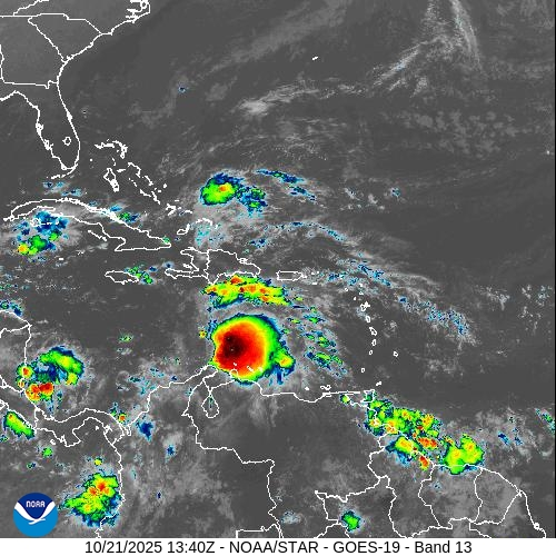
Location: 14.3N 71.7W, about 300 miles south of Port Au Prince Haiti
-
Maximum sustained winds: 50 mph
-
Minimum central pressure: 1003 millibars
Spaghetti models for Tropical Storm Melissa. See expected path
Special note about spaghetti models: Spaghetti model illustrations include an array of forecast tools and models, and not all are created equal. The Hurricane Center uses only the top four or five highest performing models to help make its forecasts.
Where is Tropical Storm Melissa and where is it going?
Special note on the NHC cone: The forecast track shows the most likely path of the center of the storm. It does not illustrate the full width of the storm or its impacts, and the center of the storm is likely to travel outside the cone up to 33% of the time.
Is Tropical Storm Melissa headed toward Florida?
As of now, the odds that Tropical Storm Melissa comes to Florida are in the state’s favor, but it will depend on when the west-to-east jet stream pattern unfolds over the contiguous U.S., says AccuWeather.
When the jet stream expands and dips farther south, it acts like a barrier that repels tropical storms or hurricanes from traveling northward.
“There will be multiple dips in the jet stream that could act to scoop up any budding tropical storm in the Caribbean. Should one of these snag the storm early, it would not be of concern for the zone from Central America to Florida,” AccuWeather wrote in its latest forecast.
“Should one of the jet stream dips not grab onto the storm until late this week, the odds increase for a possible track into the Florida Peninsula,” it added.
The Florida Panhandle will be the safest spot in the Sunshine State, according to DaSilva.
“Weighing all the odds, based on what we see for this week in the Caribbean and with the jet stream, it is highly unlikely for a tropical storm (or hurricane) to reach areas in the U.S. west of Tallahassee, Florida,” DaSilva said. “However, the chances increase farther to the east over Florida and especially South Florida to Puerto Rico and the U.S. Virgin Islands.”
Track all active Atlantic, Pacific storms and disturbances
This auto-updated graphic shows a map of all active storms in the Atlantic basin.
Can’t see the graphic? Open in a new browser.
NWS weather radar shows storms affecting Florida

Latest weather watches and warnings issued in Florida
This article originally appeared on Pensacola News Journal: Tropical Storm Melissa spaghetti models, forecast and Florida impact