Much of North Carolina’s Outer Banks region is under a tropical storm watch with Hurricane Erin expected to skirt the area this week, according to the National Hurricane Center.
The sprawling Category 4 storm is churning in the Atlantic Monday after exploding in strength at a historic rate this weekend fueling the potential for life-threatening rip currents and towering waves toward the eastern US coastline and Bermuda, all without making landfall.
The watch covers an area from Beaufort Inlet to Duck, North Carolina, and includes the Pamlico Sound. A tropical storm watch means sustained winds of 39 to 73 mph are possible in the area within around 48 hours. It’s the first such alert of the year for the Outer Banks.
At least 75 rip current rescues have been reported on beaches in New Hanover County, North Carolina, emergency officials said Monday evening. No injuries were reported, officials added.
A no swim advisory has been issued for Wrightsville Beach Tuesday, August 19 through Friday, August 22 due to “the presence of strong rip currents,” a press release reads.
Moderate rip currents were expected to ramp up in the area due to Erin, the weather service said in a Monday morning update.
“Even though Erin is expected to remain far offshore, the threat to life from rip currents and high surf along our beaches is very real,” the National Weather Service office in Morehead City, North Carolina, warned.
Rough seas and large swells from the hurricane will reach much of the US East Coast and Bermuda starting Tuesday, with conditions expected to worsen through midweek.
Erin’s outer rain bands lashed Puerto Rico over the weekend, triggering flash flooding and power outages, and started impacting the southeast Bahamas and the Turks and Caicos Islands early Monday.
At least one airport on the Turks and Caicos Islands is closed due to the storm, the Turks and Caicos Islands Airports Authority said in a press release. Howard Hamilton International Airport on Providenciales is expected to reopen Tuesday morning, the agency said.
Erin’s life-threatening impacts
Erin is forecast to curve north-northeast between the US East Coast and Bermuda this week, remaining out over the water but growing even larger in size. The hurricane’s influence will be felt not through direct landfall, but through water: large, pounding surf, dangerous currents and coastal flooding during high tides.
Erin will remain a powerful major hurricane – Category 3 or greater – through at least midweek.
Dare County in North Carolina — home to much of the Outer Banks — issued a local state of emergency Sunday that includes a mandatory evacuation order for Hatteras Island.
“Portions of N.C. Highway 12 on Hatteras Island will likely be impassable for several days,” a county news release warned, noting coastal flooding and ocean overwash are expected from Tuesday through Thursday. The road may become impassible starting with Tuesday’s late afternoon high tide, according to the county.
Nearby Hyde County also issued a local state of emergency and mandatory evacuation order for Ocracoke Island “due to the anticipated flooding impacts,” according to a Sunday news release.
Extensive beach erosion is likely, with waves of 20 feet or more forecast this week, according to the National Weather Service. Waves of this size “will likely inundate and destroy protective dune structures,” which could lead to severe flooding inland, National Park Service officials at Cape Hatteras National Seashore warned Monday.
Damaged dunes and beach erosion are huge hazards for the Outer Banks’ beachfront homes.
Multiple homes have collapsed into the ocean in recent years, including at least three around this time last year from Hurricane Ernesto’s waves. At least two homes in Rodanthe are “very, very vulnerable” to collapse this week, Cape Hatteras National Seashore Superintendent Dave Hallac told CNN affiliate WRAL.
As if that wasn’t enough, the tides around the Outer Banks will be at their highest levels of the month on Wednesday and Thursday. Adding Erin’s large waves to the mix could cause serious coastal flooding issues.
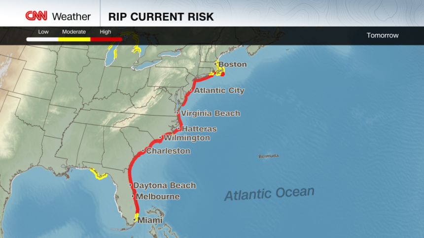
The rip current risk will climb sharply Tuesday through Thursday from Florida to New England – even under sunny skies.
So far this year, 44 people have died from rip currents and other surf-zone hazards in the US, according to the NWS. Rip currents usually take more lives each year than lightning, hurricanes and tornadoes combined, the service says, behind only heat and flooding.
Tuesday will feature a high risk of rip currents along much of the East Coast. – CNN Weather
With peak summer crowds still flocking to the coast, officials are urging beachgoers to stay out of the water when rip current alerts are in effect.
“This is not the week to swim in the ocean,” Dare County Emergency Management said in its evacuation order. “The risk from surf and flooding will be life-threatening.”
The heaviest rain from Erin in Puerto Rico eased up early Monday, but showers from the hurricane’s outer bands lingered. A flood watch remains in effect for the island through Monday evening, according to the National Weather Service.
Additional rainfall of up to 6 inches is forecast over the Turks and Caicos and the eastern Bahamas through Tuesday, according to the hurricane center. Flash flooding, landslides and mudslides are possible.

A truck drives through a flooded road as Category 3 Hurricane Erin leaves the region in Naguabo, Puerto Rico, on August 16, 2025. – Ricardo Arduengo/AFP/Getty Images
Tropical storm warnings are in effect for the Turks and Caicos Islands and the southeast Bahamas. A tropical storm watch is in place for the central Bahamas.
Bermuda also lies in Erin’s path of influence, with forecasters expecting the island to see very rough seas and possibly tropical storm–force winds later this week.
Extreme rapid intensification
Erin’s impact began over the weekend, when it logged one of the fastest rapid intensification bursts on record in the Atlantic. In just over a day, the storm jumped from a tropical storm to a Category 5 hurricane, peaking at 160 mph on Saturday as it feasted on exceptionally warm water and favorable atmospheric conditions.
It then eased to Category 3 while undergoing an eyewall replacement cycle – a structural reset where a new, larger eyewall forms and steals energy from the old one. Winds dip during the swap, but the storm usually grows in size.
When the eyewall replacement finished, Erin re-intensified to Category 4, with a larger wind field.
The hurricane’s rapid intensification over the weekend was a stark reminder of how quickly storms can strengthen in a warming climate. It’s also unusual to see a Category 5 storm form so early in the season, particularly outside of the Gulf or Caribbean.
Atlantic hurricane season is ramping up
The hurricane center has already identified a tropical wave behind Erin that has a medium chance of developing into a tropical depression or tropical storm within the next seven days. It’s too early to say whether this system will materialize or where it may go, but forecasters are watching it closely.
Despite Erin churning up cooler waters beneath the surface, there’s still plenty of warm water for storms to tap into as sea surface temperatures remain well above average. They aren’t quite as warm as the record levels reached in 2023 and 2024, but are still far warmer than they’d be in a world that wasn’t heating up.
August is when the tropics usually come alive: The busiest stretch of the season typically spans from mid-August to mid-October. Forecasters expect above-average tropical activity this year.
CNN Meteorologist Brandon Miller contributed to this report.
For more CNN news and newsletters create an account at CNN.com