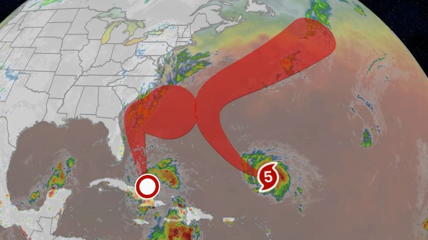
Tropical storm watches have been issued in Florida ahead of newly-formed Tropical Depression Nine. Imelda will pose a danger of heavy rain, high winds and coastal flooding to the Southeast U.S. Meanwhile, Humberto has become the second Category 5 hurricane in the Atlantic Basin so far this season.
There is still uncertainty as to the details of how this will all shake out into next week, so please check back with us at weather.com for important updates in the days ahead as the forecast gradually becomes clearer. All interests in the Bahamas, the U.S. East Coast from Florida to North Carolina and Bermuda should closely monitor the progress of this forecast and have their hurricane plans ready to go.
(MORE: Our Map Tracker Page)
Future ‘Imelda’ A Bahamas, U.S. Threat
Happening Now
Tropical Depression Nine is currently near Cuba and the southern Bahamas and will continue wringing out showers with locally heavy rain and gusty winds in those areas today.
Tropical storm watches are in effect across the east coast of Florida from the Palm Beach/Martin County Line northward to the Flagler/Volusia County Line, which means that tropical storm conditions are possible within 48 hours.
Tropical storm warnings have also been issued for portions of the Bahamas, including Nassau and Freeport. Tropical storm conditions will expand northward across the Bahamas through the weekend.
The system is expected to become Tropical Storm Imelda this weekend and could become a hurricane by Monday or Tuesday.

Where Imelda Could Go
Imelda is most likely expected to stall off the Southeast coast for a day or two beginning Tuesday before turning east away from the coast, possibly toward Bermuda. Originally, Imelda was possibly forecast to make landfall in the Carolinas; however, models today have pulled the forecast away from this option.
Models have also called for this storm to slow down, which means it could take longer to move through the Bahamas. It also means that since it will linger near the Southeast, the flood threat remains, even though models are pulling the storm away from a direct landfall. Thanks to the pull of Major Hurricane Humberto and the atmospheric conditions over the Southeast for the threat of a direct landfall decreasing.
Some of the forecast model possibilities are illustrated by the map below.
(MORE: How To Read Spaghetti Models During Hurricane Season)

Spaghetti Models
How Strong Could Imelda Get?
Deep, warm ocean water, including the warm Gulf Stream current, as well as winds spreading apart aloft will fuel some modest strengthening the next few days.
Eventually, shearing winds, some dry air and the slow-moving storm churning up cooler water could limit any further intensification of Imelda.
For these reasons, this system is expected to be either a tropical storm or low-end hurricane near the Southeast.

Forecast Wind Shear
Early Look At Possible Impacts
Imelda will likely have at least some significant impacts along parts of the Southeast coast even if it never makes a landfall.
What could become the biggest threat from this storm is rainfall flooding, especially if Imelda lingers around for multiple days. The slower the storm moves, the heavier the rain potential.
Before that happens, locally heavy rain not from Imelda is possible over parts of the Southeast this weekend. There are even flood watches in effect for parts of Virginia and North Carolina from this unrelated system, which will expire by the end of the day today.
After that, the threat will rise.
“Moisture from Tropical Depression Nine will lead to a threat of heavy rainfall well to the north from Coastal Georgia through the Carolinas and into the southern Mid-Atlantic states into early next week which could cause flash, urban, and river flooding,” warns the National Hurricane Center.
The closer Imelda’s center gets to the Southeast coast, the greater the threat from heavy rain not just near the coast, but also farther inland.

Rainfall Outlook
Days of onshore winds will generate dangerous high surf, rip currents and coastal flooding up and down the Eastern Seaboard from Florida to New England, due not only to Imelda but also to Humberto churning up the ocean. Flooding and battering waves over multiple high tide cycles could lead to beach erosion in some areas.
Imelda could also draw close enough to produce strong wind gusts along parts of the Southeast coast, even if it never makes a landfall, as Hurricane Erin did in August.
Hurricane Humberto
We’re also watching Humberto, which has become the second Category 5 hurricane in the Atlantic Basin so far this season.
It is centered over 300 miles northeast of the Leeward Islands. It’s moving northwest and is no threat to the Leeward Islands nor the rest of the Caribbean. However, the storm is expected to remain a powerful major hurricane for several days.
Humberto underwent rapid intensification on Friday, becoming a Category 4 storm by the end of the day. The storm’s maximum sustained winds jumped from 65 mph to 145 in only 24 hours, making it the third storm to do so this year in the Atlantic Basin, following Erin and Gabrielle.
Humberto could be a threat to Bermuda Tuesday or Wednesday, but is unlikely to be a direct U.S. threat. While Humberto may lose some intensity by then, it is still expected to be a formidably strong hurricane through Wednesday.
(MORE: What Does The Forecast Cone Mean?)

Projected Path
Recap: Disturbance In The Caribbean
This tropical wave brought widespread rainfall of 1 to 4 inches across Puerto Rico, with the heaviest totals being reported across the southern parts of the territory. No surprise that this heavy rainfall brought some flood and landslide reports across Puerto Rico highways, with one car being washed out with people still inside. At least one person was killed.