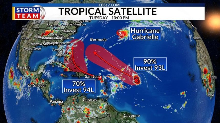
RALEIGH, N.C. (WNCN) — While Hurricane Gabrielle moves away from the United States, two more waves developing behind it have high odds for development within the next week.
As of Tuesday night, Invest 93L, which is 750 miles east of the Leeward Islands, has odds for development up to 90% within the next seven days, and 70% within the next 48 hours.
Invest 94L, which is in the northeastern Caribbean Sea east of Puerto Rico, has odds for development up to 70% within the next week, but only 30% within the next 48 hours.
Invest 94L
While 94L has the lowest odds for development of the two tropical waves, it looks like it could move near North Carolina early next week. While still not totally organized, it’s bringing gusty, stormy weather to the Windward and Leeward Islands.
That rough weather will impact Puerto Rico, the Virgin Islands and the Dominican Republic on Wednesday as the tropical wave moves west-northwestward. Once it gets into the southwestern Atlantic near the Bahamas, Invest 94L could develop into a tropical depression.
After this, there’s a bit of uncertainty about where it goes.
Most computer models are in decent agreement that it will move to the northwest, before turning to the northeast, but it’s when the turn to the northeast occurs that could matter for impacts to North Carolina.
The wave should move around an area of high pressure in the Atlantic, but if a cold front that is set to move through central North Carolina late this week stalls off our coast, that front can act as a pseudo “barrier” and turn the system away to the northeast.

If the front slows down or the wave speeds up, it could end up tracking closer to the coast. Models right now have the front off the coast, guiding the storm away, but with a spread in model solutions, the forecast will need to be fine-tuned over the next few days.
If it does move close to North Carolina, that would occur between Monday and Wednesday of next week.
Invest 93L
The tropical wave known as 93L will likely become a tropical depression or storm within the next few days. 93L could take a similar path to Gabrielle, curving around Atlantic high pressure and staying out in the open Atlantic. Depending on how close these two systems (93L and 94L) get to each other they could do a “dance” with each other called the “Fujiwhara Effect.”

The Fujiwhara Effect is when two low pressures (in this case, two tropical systems) are spinning and moving in the same general direction “dance” around each other around a center point.
A weaker system can be “absorbed” by the stronger one, while systems that are more similar in strength can dance around each other before going off on their own paths, or even merge. This does not mean two systems can make one larger system, however.
It’s too early to determine if that will happen with these two tropical waves once they strengthen, but it’s a factor to watch through the end of the week, as it can make forecasting their paths a bit more complicated.
Next names for 2025 Atlantic season
The next names on the list are Humberto and Imelda. We’ve only had seven named storms this year in the Atlantic, with two of them becoming hurricanes. It is important to note that both of those hurricanes were Category 4 or stronger.

On average, our seventh named storm has formed by September 3 and our second major hurricane has formed by September 19, according to the National Hurricane Center.
The forecast will develop over the next few days, so keep updated with the CBS17 Storm Team.
Copyright 2025 Nexstar Media, Inc. All rights reserved. This material may not be published, broadcast, rewritten, or redistributed.
For the latest news, weather, sports, and streaming video, head to CBS17.com.