About 16 miles off the Wisconsin shore, the conditions in Lake Michigan were considered normal and favorable. The winds blew in from the southeast at seven knots, considered a gentle breeze on the Beaufort scale.
The Laurentian, a research vessel filled with scientists from the National Oceanic and Atmospheric Administration and Hibbard Inshore, had ventured into the Wisconsin Shipwreck Coast National Marine Sanctuary. The goal was to survey some of Lake Michigan’s deepest shipwrecks, where the least amount is known.
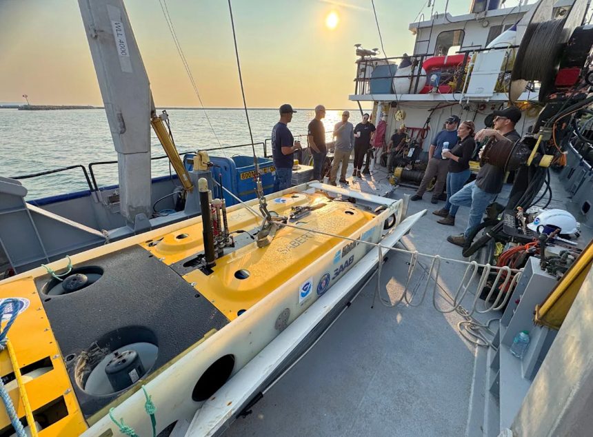
But when a 1½-ton unmanned robot was hoisted out of the water, it swung like a massive pendulum, with six people and multiple attempts needed just to land it back safely on the Laurentian’s deck.
The robot — known as an autonomous underwater vehicle, or AUV — is equipped with special laser scanners, and can capture images so clear, individual invasive mussels anchored to the wrecks are visible. It’s the first time such technology has been used to investigate wrecks in Lake Michigan.
But it also revealed just how hard it is to explore the Great Lakes, and why scientists know so little about them.
“We know less about Lake Michigan than we thought we did,” said Russ Green, superintendent with Wisconsin’s national marine sanctuary. “As we push deeper into Lake Michigan, we need autonomous technology to help us figure out what’s going on down there.”
The same technology was used to map the famous Endurance shipwreck, which lies 10,000 feet beneath the water near Antarctica. Endurance was the famous three-masted ship that sank in the Weddell Sea in 1915. Expedition leader Sir Ernest Shackleton and the crew of 27 all survived.
Freight steamer, fireboat among another record number of Lake Michigan shipwreck discoveries
Want to explore a Lake Michigan shipwreck? Wisconsin’s marine sanctuary just made it easier.
A freighter carrying hundreds of Nash automobiles
During the weeklong expedition, the team first tested out the technology on the Northerner, a shipwreck that lies in shallower waters close to shore. The 80-foot schooner rests about 135 feet below the surface, about five miles off Port Washington within the boundaries of the shipwreck sanctuary.
Brad Hibbard, president of Hibbard Inshore, looks at images of the Northerner, an 80-foot schooner rests about 135 feet below the surface, about five miles off Port Washington within the boundaries of the shipwreck sanctuary. Scientists used an unmanned underwater robot equipped with special laser scanners that capture images so clear, individual invasive mussels anchored to the wrecks are visible.
The unmanned underwater robot — described by Green as the Swiss Army knife of research tools — can move freely through the water, scanning the lakebed in two passes. The first pass provides a rough sketch of the wreck and identifies any potential obstructions. The second pass gets in closer and uses advanced laser scanning technology to create incredibly detailed images.
The laser scanner can also capture areas within the debris field much farther from the wreck than other technologies.
Testing the system on the Northerner revealed parts of the ship’s rigging lying 60 feet away — remnants the team hadn’t known existed, said Caitlin Zant, maritime archaeologist at Wisconsin’s national marine sanctuary.
The team also captured the most detailed images yet of the Senator, the sanctuary’s deepest shipwreck, which lies in about 415 feet of water. The freighter was on its way to a car show in Detroit with 268 Nash automobiles when it sank in late 1929. It had collided with the bulk carrier the Marquette, laden with iron ore. Nine of the crew members lost their lives when it sank. Not many images have been captured of the Senator due to the challenges of diving at that depth. Its exact location has yet to be released publicly by the state.
The images revealed new details about the Senator’s condition and layout.

A scan of the Senator, a freighter that sank in 1929, using an unmanned underwater robot. The Senator was carrying hundreds of Nash automobiles and is the deepest known shipwreck in the Wisconsin Shipwreck Coast National Marine Sanctuary. This was the first time these advanced laser scanners were used to image shipwrecks in Lake Michigan.
For instance, the second lifeboat was imaged for the first time, sitting about 100 yards off the starboard side of the ship, Zant said. Images show the ship’s car elevator on the deck, along with signs that the stern of the vessel has been collapsed slightly within the lakebed, likely due to its initial impact, she said. Nash automobiles were also visible at the break in the hull.
Overall, the scans offer valuable insight into how the ship settled and the extent of damage from the sinking, adding to the growing picture of one of the sanctuary’s most recent wrecks.
Time, patience, flexibility necessary for Great Lakes research
The weeklong expedition opened new possibilities for underwater exploration in the Great Lakes.
Detailed images allow scientists, historians and the public to better understand shipwrecks and the region’s maritime history, which in turn supports long-term preservation, Hibbard said.
Green noted that even robust wrecks like the Senator are rapidly deteriorating due to invasive mussels, making it critical to gather baseline data while the wrecks are still intact. The technology may also help researchers study the lakebed’s environment and features in greater detail.

Kelly Smith, a remotely operated vehicle supervisor and surveyor with Hibbard Inshore prepares equipment on board a vessel while preparing to head out to search for shipwrecks, sinkholes and other geographical formations on the bottom of Lake Michigan, from Port Washington on Aug. 6, 2025.
Although the team faced setbacks and couldn’t survey as many wrecks as planned, Zant said, the tools helped the team collect large amounts of data in a short time.
The expedition underscored how essential time, patience and flexibility are to this kind of research.
A big part of research is accepting that you’re not always in control, Zant said. “The fact that we do as much as we do is really remarkable.”
Invasive mussels drastically altered the Great Lakes. Now, scientists are fighting back.
Lake Michigan holds much mystery. But does it have the equivalent of a Bermuda triangle?
Caitlin Looby covers the Great Lakes and the environment for the Milwaukee Journal Sentinel. Reach her at clooby@gannett.com, and follow her on X @caitlooby.
Caitlin’s work is supported by the Brico Fund, Fund for Lake Michigan, Barbara K. Frank, and individual contributions. Grants and donations help make this reporting possible. The Journal Sentinel maintains full editorial control.
This article originally appeared on Milwaukee Journal Sentinel: Underwater robot produces stunning scans of shipwrecks in Lake Michigan