If you’ve ever looked at a map of Florida, you might have noticed the state nearly takes away all of Alabama’s access to the Gulf. Is Florida just greedy, or is there more to the story?
While Floridians are obviously aware of the Panhandle, some might not actually know where it ends or why it’s a part of our state.
Here’s what to know.
Why is it called a Panhandle?
Well … it does look like one, doesn’t it?
The official definition of a panhandle is a narrow projection of a larger territory. According to the Online Etymology Dictionary, the term originated in the 1850s, referring to the spike of land in Virginia (now West Virginia) between Ohio and Pennsylvania.
There are nine states with panhandles, including Florida, Alaska, West Virginia, Connecticut, Idaho, Maryland, Nebraska, Oklahoma, and Texas.
What is considered the Florida Panhandle?
According to the Florida Department of Environmental Protection, the official length of the panhandle goes southwest from Pensacola to Cedar Key along the Gulf of America, previously referred to as the Gulf of Mexico. It spans roughly 200 miles and is bordered by Alabama to the north and west, and Georgia to the north.
It includes both the Emerald Coast and the Forgotten Coast along the Gulf, as well as the scenic Highway 30A.
What cities are in the Florida Panhandle?
The largest city in the panhandle is the state’s capital, Tallahassee. Sitting in Leon County, it is the eighth most populous city in the state, with a population of roughly 205,000.
Other well-known cities in the panhandle include:
Why did Florida get the Panhandle and not Alabama?
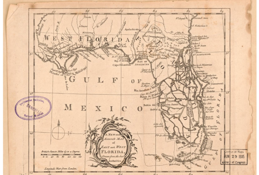
A ‘new and accurate map of east and west of Florida’ from the London magazine dated 1765 by the Library of Congress.
The Florida Panhandle was originally part of Spanish West Florida. However, the land, which included most of Alabama, was considered just “West Florida” after Great Britain acquired the land in 1763 from the Spanish.
After the Revolutionary War, Spain regained control of the land. Then came the Louisiana Purchase, where Alabama Media Group reports that the U.S. announced West Florida, up to the old Perdido River dividing line, had been included.
This soon left Spanish Florida surrounded by American territory. This resulted in territorial disputes for decades until troops were sent to occupy the area up to the Perdido River in 1810. Though Spain still objected to the land grab, Alabama became a state in 1819, including the portion of West Florida.
Alabama Media Group reported that in 1821, Spain surrendered the rest of Florida to the U.S., and what was left of West Florida was lumped together with East Florida. Florida entered the Union as a state in 1845.
According to the Destin Log, the Florida Panhandle was almost sold to Alabama in 1869. The Alabama governor, David Lewis, offered the Sunshine State $1 million for everything from the current location of the Flora-Bama Bar to the Apalachicola River. And Florida almost took Alabama up on the offer.
In May 1869, three commissioners signed a cession agreement on behalf of the Alabama and Florida legislatures. Later that year, Panhandle residents actually got to vote on the matter — approving cession by a nearly two-to-one margin of 1,162 to 661 votes.
Following the referendum, the cession effort stalled out in the Florida Legislature. During the 1870-71 session, the Florida House of Representatives passed legislation to proceed with the sale. The effort failed in the Florida Senate. Processionists tried again in 1873 but were unable to muster enough enthusiasm.
That wasn’t the first time the idea of moving the Panhandle of Florida to Alabama was discussed. Actually, there have been petitions and legislative actions that occurred at the state level in Alabama in 1819, 1821, 1826, 1838, and 1840.
Contributing: The Destin Log
This article originally appeared on Pensacola News Journal: What is considered the Florida Panhandle? See official distinction