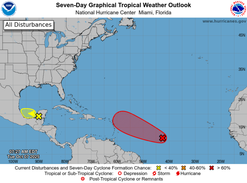
Tropical Storm Jerry is looming in the Atlantic Ocean.
The National Hurricane Center said in an advisory on Oct. 7 it expects a new tropical depression to form in the Atlantic “over the next day or so.” If it develops into the Atlantic hurricane season’s 10th named storm, it would be named Jerry.
The low pressure area forecasters are tracking was located a little more than 1,000 miles east of the Windward Islands, the hurricane center said in the advisory, with showers and thunderstorms gradually becoming better organized.
Environmental conditions appear favorable for storm development, the hurricane center said. So far this season, the Atlantic Ocean’s hurricane basin has produced four hurricanes and five tropical storms.
The area of disturbed weather likely to become Jerry is moving quickly west-northwestward across the central tropical Atlantic. In an early Oct. 7 forecast, the hurricane center put the chances of storm formation at 80% over 48 hours and 90% over seven days.
Tropical Storm Jerry is expected to form in the Atlantic Ocean at some point in the next day or so, according to the National Hurricane Center.
Many of the ensemble models used to forecast potential hurricane track indicate the system eventually could move off toward the north in the Atlantic as several other storms have done this season, but it’s too soon to say for sure. Even if it does whirl out into the Atlantic, it could still send deadly and dangerous swells and hazardous surf and currents to the coast.
The hurricane center also is watching a disturbed area over the Bay of Campeche in the Southwestern Gulf of Mexico that has a minimal chance of formation but is forecast to bring heavy rains to portions of Belize, the Yucatan Peninsula and southern Mexico this week.
Atlantic storm tracker
This forecast track shows the most likely path of the center of the storm. It does not illustrate the full width of the storm or its impacts, and the center of the storm is likely to travel outside the cone up to 33% of the time.
Hurricane Priscilla could impact southern Baja California peninsula, forecasters say
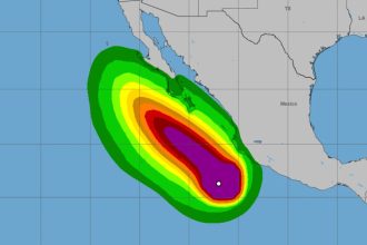
In the Pacific, Hurricane Priscilla continues to strengthen and is expected to impact the southern Baja California Sur beginning Oct. 7 and the southwest U.S. later this week.
In an early morning advisory, hurricane center forecasters said Priscilla was located about 230 miles south of the southern tip of Baja California with maximum sustained winds near 100 mph with higher gusts.
Forecasters said additional strengthening is expected, and Priscilla could be at or near major hurricane on Oct. 7, with weakening expected to begin on Wednesday, Oct. 8 and continue through the rest of the week. The center of Priscilla is forecast to move parallel to, but offshore of, the coast of west-central Mexico and Baja California Sur during the next couple of days.
Over the next couple of days, 1 to 2 inches of rain are expected in southern Baja California Sur, with local totals up to 4 inches possible. Forecasters also said moisture from Priscilla should bring heavy rainfall potential over the southwest U.S. late this week into the weekend.
Swells generated by Priscilla are affecting portions of the coast of southwestern and west-central Mexico, as well as portions of the coast of the southern Baja California peninsula, forecasters said. These swells are likely to cause “life-threatening surf and rip current conditions,” according to the advisory.
Prepare now for hurricanes
Delaying potentially lifesaving preparations could mean waiting until it’s too late. “Get your disaster supplies while the shelves are still stocked, and get that insurance checkup early, as flood insurance requires a 30-day waiting period,” the National Oceanic and Atmospheric Administration recommends.
-
Develop an evacuation plan. If you are at risk from hurricanes, you need an evacuation plan. Now is the time to begin planning where you would go and how you would get there.
-
Assemble disaster supplies. Whether you’re evacuating or sheltering in place, you’re going to need supplies not just to get through the storm but for a possibly lengthy aftermath, NOAA said.
-
Get an insurance checkup and document your possessions. Contact your insurance company or agent now and ask for an insurance checkup to make sure you have enough insurance to repair or even replace your home and belongings. Remember, home and renters insurance don’t cover flooding, so you’ll need a separate policy for those. Flood insurance is available through your company, agent or the National Flood Insurance Program.
-
Create a family communication plan. NOAA says you should take the time now to write down a hurricane plan and share it with your family. Determine family meeting places and make sure to include an out-of-town location in case of evacuation.
-
Strengthen your home. Now is the time to improve your home’s ability to withstand hurricanes. Trim trees and install storm shutters, accordion shutters, and impact glass, and seal outside wall openings.
Gabe Hauari is a national trending news reporter at USA TODAY. You can follow him on X @GabeHauari or email him at Gdhauari@gannett.com.
This article originally appeared on USA TODAY: Tropical Storm Jerry could soon form in the Atlantic. See tracker.