Tropical Storm Jerry is bringing heavy rain and gusty winds to the northern Leeward Islands Friday, Oct. 10, as it continues to move quickly to the northwest.
One of the biggest changes overnight is that the National Hurricane Center is now predicting Jerry will not become a hurricane.
➤ Weather alerts via text: Sign up to get updates about current storms and weather events by location
Jerry weakened overnight and is encountering strong wind shear. Slow strengthening is possible over the weekend.
Current predictions show maximum sustained winds topping out at 70 mph, just short of the 74 mph to be designated as a hurricane.
A dip in the jet stream is expected to turn Jerry to the north and then curve it out to sea, keeping it away from Florida and the U.S., according to AccuWeather.
Highlights on what Tropical Storm Jerry is doing now
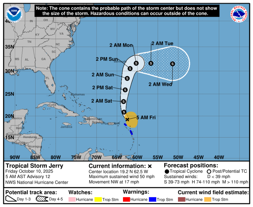
Special note on the NHC cone: The forecast track shows the most likely path of the center of the storm. It does not illustrate the full width of the storm or its impacts, and the center of the storm is likely to travel outside the cone up to 33% of the time.
-
Location: 80 miles north-northeast of the northern Leeward Islands; 1,229 miles southeast of West Palm Beach
-
Maximum sustained winds: 50 mph
-
Movement: northwest at 17 mph
Spaghetti models for Tropical Storm Jerry
Special note about spaghetti models: Illustrations include an array of forecast tools and models, and not all are created equal. The hurricane center uses only the top four or five highest performing models to help make its forecasts.
See map of watches, warnings issued for Florida
No tropical storm or hurricane watches or warnings associated with Tropical Storm Jerry have been issued for Florida or the U.S.
How strong is Tropical Storm Jerry and where is it going?
At 5 a.m., the center of Tropical Storm Jerry was located near latitude 19.2 North, longitude 62.5 West.
Jerry is moving toward the northwest near 17 mph. A turn toward the north is expected tonight into Saturday, followed by a northward to north-northeastward motion through the rest of the weekend.
On the forecast track, the center of Jerry will continue passing to the north of the Leeward Islands this morning, then move away from the islands later today.
Maximum sustained winds are near 50 mph, with higher gusts.
Little change in strength is expected today, but slow strengthening is possible over the weekend. Jerry is no longer predicted to become a hurricane.
Tropical-storm-force winds extend outward up to 185 miles, mainly to the east of the center.
The estimated minimum central pressure is 1007 mb.
Is there a hurricane coming toward Florida?
No. Tropical Storm Jerry is no longer expected to strengthen into a hurricane, according to the National Hurricane Center.
The storm is forecast to curve north and then east, staying away from Florida and the U.S. east coast.
However, Florida can expect rough surf and dangerous rip currents along the coast from the combined effects of a nor’easter developing off the east coast and Tropical Storm Jerry, according to Alex DaSilva, AccuWeather lead hurricane expert in an email Oct. 9.
“The coastal storm, combined with Jerry, will bring rough surf and rip currents to Florida through at least Monday. Both storms will contribute to the rough seas,” DaSilva said.
How large is Tropical Storm Jerry?

Satellite view of Tropical Storm Jerry 7 a.m. Oct. 10, 2025.
While not the largest storm to ever form in the Atlantic basin, Jerry isn’t a tiny storm.
Tropical-storm-force winds extend 185 miles from the center.
To put it in perspective, that’s about the distance from Jacksonville to Palm Bay or from Orlando to Palm Beach.
Watches, warnings associated with Tropical Storm Jerry
A tropical storm watch is in effect for:
-
St. Barthelemy and St. Martin
-
Guadeloupe and the adjacent islands
A tropical storm watch is issued when a tropical cyclone containing winds of 39 to 73 mph or higher poses a possible threat, generally within 48 hours. These winds may be accompanied by storm surge, coastal flooding, and/or river flooding, according to the National Weather Service.
Key messages from the National Hurricane Center: What you need to know about Tropical Storm Jerry
-
Heavy rainfall will impact portions of the Leeward Islands, British Virgin Islands, U.S. Virgin Islands, and Puerto Rico through today, which could result in flash flooding, particularly in urban areas and in steep terrain.
-
Tropical storm conditions, mainly in gusts, could still affect portions of the northern Leeward Islands this morning. These conditions are expected to subside later today as Jerry moves away from the area.
Current forecast: How strong could Tropical Storm Jerry get?
-
As of 5 a.m., Oct. 10: 50 mph
What impacts could Tropical Storm Jerry have and what areas could be affected?
Wind: Tropical storm conditions, mainly in gusts, are expected in the warning area and are possible in the watch area this morning.
Rainfall: Through today, 4 to 6 inches of rain are expected across the island of Barbuda. Elsewhere across the Leeward and Virgin Islands, 2 to 4 inches of rain are expected. This rainfall brings a risk of flash flooding, especially in urban areas and in steep terrain. For portions of Puerto Rico, moisture associated with Jerry combined with local orographic effects may result in up to 2 to 4 inches of rain, with isolated amounts of 6 inches possible.
Surf: Swells generated by Jerry are affecting the Leeward Islands, Windward Islands, the Virgin Islands, and Puerto Rico, and are likely to cause life-threatening surf and rip current conditions. These swells are expected to spread toward the rest of the Greater Antilles today and tonight.
Interactive map: What tropical storms, hurricanes have impacted your area in the past?
Stay informed. Get weather alerts via text
What’s next?
We will update our tropical weather coverage daily.
Download your local site’s app to ensure you’re always connected to the news. And look for our special subscription offers here.
This story has been updated to include new information.
This article originally appeared on Sarasota Herald-Tribune: Tropical Storm Jerry storm tracker, spaghetti models. Florida impact