Are you ready for the busiest weeks of hurricane season?
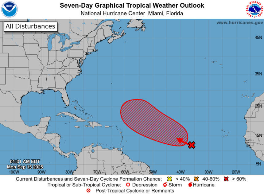
A tropical wave in the central Atlantic has a very high chance of strengthening over the next seven days, and a low chance over the next 48 hours.
The National Hurricane Center said a tropical depression is likely to form by the middle to later part of this week.
➤ Weather alerts via text: Sign up to get updates about current storms and weather events by location
If maximum sustained winds reach at least 39 mph, it would become Tropical Storm Gabrielle, the seventh named storm of the 2025 Atlantic hurricane season.
Dry air in the Atlantic has been making it difficult for tropical waves to strengthen.
Those conditions are expected to change over the next day or two, the Hurricane Center said.
Less dry air, Saharan dust and wind shear in the atmosphere later this week will help waves moving off Africa to develop, according to AccuWeather.
Here’s the latest advisory from the National Hurricane Center as of 2 a.m., Sept. 15:
What tropical waves, disturbances are in Atlantic basin now?
A tropical wave over the central tropical Atlantic is producing a large area of disorganized showers and thunderstorms.
Although dry and stable air is expected to limit development during the next day or so, gradual development is anticipated thereafter, and a tropical depression is likely to form by the middle to latter part of this week as the system moves west-northwestward at 10 to 15 mph over the central tropical Atlantic.
-
Formation chance through 48 hours: low, 30 percent.
-
Formation chance through 7 days: high, 80 percent.
Other tropical waves being monitored by National Hurricane Center:
-
The axis of a central Atlantic tropical wave is near 48W from 01N to 20N. It is moving westward at around 11 to 17 mph. Scattered moderate and isolated strong convection is noted from 14N to 20N between 45W and 50W.
-
The axis of an eastern Caribbean tropical wave is near 68W south of 20N. It is moving westward at around 17 mph. Scattered moderate convection is noted from 15N to 17N between 65W and 68W.
What do the colored, hatched areas on the NOAA map mean?
The hatched areas on the National Hurricane Center’s tropical outlook map indicate “areas where a tropical cyclone — which could be a tropical depression, tropical storm or hurricane — could develop,” said National Hurricane Center Deputy Director Jamie Rhome.
The colors make it visibly clear how likely a system could develop, with yellow being low, orange medium, and red high.
The National Hurricane Center generally doesn’t issue tropical advisories until there is a named storm, but there is an exception.
“If a system is near land and there is potential for development, the National Hurricane Center won’t wait before it issues advisories, even if the system hasn’t become an actual storm. This gives residents time to prepare,” Rhome said.
Is there a hurricane coming toward Florida?
Not at this time, but it’s too early to tell where the tropical waves out there will go or who they will impact.
Also unknown is how much they’ll strengthen, but remember there’s a very high chance of a tropical wave in the Atlantic will become a tropical depression later this week, according to the National Hurricane Center.
Who is likely to be impacted by tropical waves out there?
It’s too early at this time to determine if there will be any impact to Florida or the U.S. from the tropical waves.
Forecasters urge all residents to keep an eye on the tropics and to always be prepared.
Officials regularly encourage Florida residents to prepare for storms before a hurricane is approaching, while shelves are fully stocked and you aren’t battling crowds all rushing to the store at the same time.
“It only takes one storm to make it an impactful year for your community,” the National Hurricane Center Miami posted on X.
➤ See list of emergency supplies you can now buy tax free
On Aug. 1, specific hurricane supplies became permanently tax-free in Florida, ranging from batteries to generators.
➤ Don’t have a hurricane supply kit? From the basics to the extras, here’s what you need
Here are some of the basics you should have:
-
Two-week supply of medications
-
A go-bag with essential supplies in case you need to leave quickly
-
Portable cellphone chargers
-
List of emergency phone numbers, including those for family members
-
Copy of your insurance policy
Florida weather radar for Sept. 15, 2025

Weather watches and warnings issued in Florida
When is the Atlantic hurricane season?
The Atlantic hurricane season runs from June 1 through Nov. 30.
Ninety-seven percent of tropical cyclone activity occurs during this time period, NOAA said.
The Atlantic basin includes the northern Atlantic Ocean, Caribbean Sea and Gulf of America, as the Gulf of Mexico is now known in the U.S. per an order from President Trump. NOAA and the National Hurricane Center are now using Gulf of America on its maps and in its advisories.
When is the peak of hurricane season?

Hurricane season’s ultimate peak is Sept. 10 but the season goes through Nov. 30. Credit: NOAA
The peak of the season is Sept. 10, with the most activity happening between mid-August and mid-October, according to the Hurricane Center.
Hurricane names for 2025 season
Here are the names for the 2025 Atlantic hurricane season, along with how to pronounce them. The first hurricane of the season typically forms Aug. 11.
-
Erin: (Aug. 11; hurricane Aug. 15; major hurricane Aug. 16)
National Hurricane Center map: See what forecasters watching now
Systems currently being monitored by the National Hurricane Center include:

Why does NHC say ‘tropical cyclone’ on its maps instead of hurricane or tropical storm?
Tropical cyclone is the generic term used by the National Weather Service, NOAA and the National Hurricane Center for any tropical system, even if it’s in the tropical Atlantic basin.
To be more precise, a tropical cyclone is a “rotating, organized system of clouds and thunderstorms that originates over tropical or subtropical waters and has closed, low-level circulation,” NOAA sadi.
Once maximum sustained winds reach 74 mph, what it is called is determined by where it originated:
-
Hurricane: for storms in the North Atlantic, central North Pacific, and eastern North Pacific.
-
Typhoon: for storms in the Northwest Pacific.
-
Cyclone: for storms in the South Pacific and Indian Ocean.
Interactive map: Hurricanes, tropical storms that have passed near your city
Stay informed. Get weather alerts via text
What’s next?
We will update our tropical weather coverage daily.
Download your local site’s app to ensure you’re always connected to the news. And look for our special subscription offers here.
This article originally appeared on Fort Myers News-Press: Hurricane Center tracking tropical wave expected become depression